Browse "Cities"
-
Article
Rossland
Rossland, BC, incorporated as a city in 1897, population 4,140 (2021 census), 3,729 (2016 census). The City of Rossland is located 10 km southwest of Trail in the eroded crater of a long-extinct volcano of the Monashee Mountains.
"https://development.thecanadianencyclopedia.ca/images/tce_placeholder.jpg?v=e9dca980c9bdb3aa11e832e7ea94f5d9" // resources/views/front/categories/view.blade.php
https://development.thecanadianencyclopedia.ca/images/tce_placeholder.jpg?v=e9dca980c9bdb3aa11e832e7ea94f5d9
-
Article
Rouyn-Noranda
Rouyn-Noranda, Qué, City, pop 28 270 (2001c), 30 936 A (1996c), 28 958 (1991c), area 348.07 km2, inc 1986, is the largest centre in the Abitibi-Témiscaming region and its administrative capital.
"https://development.thecanadianencyclopedia.ca/images/tce_placeholder.jpg?v=e9dca980c9bdb3aa11e832e7ea94f5d9" // resources/views/front/categories/view.blade.php
https://development.thecanadianencyclopedia.ca/images/tce_placeholder.jpg?v=e9dca980c9bdb3aa11e832e7ea94f5d9
-
Article
Saint-Augustin-de-Desmaures
The area was first settled in 1658, more than 20 years before the creation of the parish of Saint-Augustin-de-Desmaures. The name Saint-Augustin was supposedly given to the parish in honour of the governor of New France from 1663-1665, Augustin de Saffray de MÉZY.
"https://development.thecanadianencyclopedia.ca/images/tce_placeholder.jpg?v=e9dca980c9bdb3aa11e832e7ea94f5d9" // resources/views/front/categories/view.blade.php
https://development.thecanadianencyclopedia.ca/images/tce_placeholder.jpg?v=e9dca980c9bdb3aa11e832e7ea94f5d9
-
Article
Saint-Bruno-de-Montarville
The seigneury of Montarville was originally granted to Pierre Boucher de Boucherville Junior in 1710. The Boucherville family combined the last 6 letters of their name to the first 2 syllables of the French word for mountain (montagne).
"https://development.thecanadianencyclopedia.ca/images/tce_placeholder.jpg?v=e9dca980c9bdb3aa11e832e7ea94f5d9" // resources/views/front/categories/view.blade.php
https://development.thecanadianencyclopedia.ca/images/tce_placeholder.jpg?v=e9dca980c9bdb3aa11e832e7ea94f5d9
-
Article
Saint-Constant
The early settlement of Saint-Constant dates back to the mid-18th century, even though the parish of Saint-Constant-de-la-Prairie-de-la-Magdeleine was only officially created in 1841.
"https://development.thecanadianencyclopedia.ca/images/tce_placeholder.jpg?v=e9dca980c9bdb3aa11e832e7ea94f5d9" // resources/views/front/categories/view.blade.php
https://development.thecanadianencyclopedia.ca/images/tce_placeholder.jpg?v=e9dca980c9bdb3aa11e832e7ea94f5d9
-
Article
Saint-Félicien
The town profited from the Chibougamau-Chapais mining boom of the 1950s, since nearly all the copper extracted from Chibougamau and Chapais (280 km northwest of Lac Saint-Jean) left the region via Saint-Félicien.
"https://development.thecanadianencyclopedia.ca/images/tce_placeholder.jpg?v=e9dca980c9bdb3aa11e832e7ea94f5d9" // resources/views/front/categories/view.blade.php
https://development.thecanadianencyclopedia.ca/images/tce_placeholder.jpg?v=e9dca980c9bdb3aa11e832e7ea94f5d9
-
Article
Saint-Georges
The first colonists came during the French regime to settle on seigneuries ceded to Thérèse Aubert de Lalande Gayon (Aubert-Gallion) and Gabriel Aubin de L'Isle (Aubin-de-l'Isle).
"https://development.thecanadianencyclopedia.ca/images/tce_placeholder.jpg?v=e9dca980c9bdb3aa11e832e7ea94f5d9" // resources/views/front/categories/view.blade.php
https://development.thecanadianencyclopedia.ca/images/tce_placeholder.jpg?v=e9dca980c9bdb3aa11e832e7ea94f5d9
-
Article
Saint-Hyacinthe
The history of Saint-Hyacinthe began with the granting in 1748 of a seigneury which was purchased in 1753 by Hyacinthe Delorme.
"https://d2ttikhf7xbzbs.cloudfront.net/media/media/ad1f33d3-a924-44ff-90c8-787a593a06fd.jpg" // resources/views/front/categories/view.blade.php
https://d2ttikhf7xbzbs.cloudfront.net/media/media/ad1f33d3-a924-44ff-90c8-787a593a06fd.jpg
-
Article
Saint-Jean-Chrysostome
Saint-Jean-Chrysostome, Quebec, population 18,352 (2019), 17,089 (2001 census). Saint-Jean-Chrysostome is located on the south bank of the St. Lawrence River. It is some 20 km south of Quebec City in the Chaudière-Appalaches Region. This region is characterized by fertile agricultural plains, plateaus and the majestic Appalachian mountains. (See Mountain Range.) Originally incorporated in 1965, Saint-Jean-Chrysostome became part of .
"https://d2ttikhf7xbzbs.cloudfront.net/media/media/fff2605f-e1c7-4789-b999-075715b3149b.jpg" // resources/views/front/categories/view.blade.php
https://d2ttikhf7xbzbs.cloudfront.net/media/media/fff2605f-e1c7-4789-b999-075715b3149b.jpg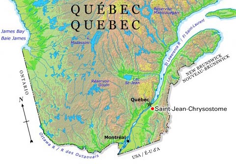
-
Article
Saint-Jean-sur-Richelieu
Saint-Jean-sur-Richelieu, Quebec, incorporated as a city in 1897, population 95,114 (2016 census), 92,394 (2011 census). The city of Saint-Jean-sur-Richelieu is located on the west bank of the upper portion of the Richelieu river, some 40 km southeast of Montreal.Saint-Jean-sur-Richelieu is located on the traditional territories of the Kanyen’kehà:ka and Abenaki. The land remains unceded and is considered Indigenous territory.
"https://d2ttikhf7xbzbs.cloudfront.net/media/single_use_images/sjsr_hôtel_de_ville.png" // resources/views/front/categories/view.blade.php
https://d2ttikhf7xbzbs.cloudfront.net/media/single_use_images/sjsr_hôtel_de_ville.png
-
Article
Saint-Jérôme
A regional metropolis situated where Rivière du Nord leaves the Laurentians, Saint-Jérôme dominates the entire Lower Laurentians. The bishopric, courthouse and CEGEP give the town an administrative function as well as industrial and commercial ones.
"https://development.thecanadianencyclopedia.ca/images/tce_placeholder.jpg?v=e9dca980c9bdb3aa11e832e7ea94f5d9" // resources/views/front/categories/view.blade.php
https://development.thecanadianencyclopedia.ca/images/tce_placeholder.jpg?v=e9dca980c9bdb3aa11e832e7ea94f5d9
-
Article
Saint John
Saint John, NB, incorporated as a city in 1785, population 69,895 (2021 census), 67,575 (2016 census). The City of Saint John, the second largest city in New Brunswick, is located at the mouth of the Saint John River on the Bay of Fundy.
"https://d2ttikhf7xbzbs.cloudfront.net/media/new_article_images/SaintJohn/8582097561_2452e069d7_z.jpg" // resources/views/front/categories/view.blade.php
https://d2ttikhf7xbzbs.cloudfront.net/media/new_article_images/SaintJohn/8582097561_2452e069d7_z.jpg
-
Article
Saint-Lambert
Saint-Lambert, Quebec, population 21,861 (2016 census), 21,555 (2011 census). Saint-Lambert was settled beginning in the 17th century. It was first incorporated as a city in 1921 and reincorporated in 2006. Saint-Lambert was amalgamated into the city of Longueuil from 2002 until 2006 when it regained its municipal status. It is located along the South Shore of the St. Lawrence River across from Montreal, and is connected to that city by the Victoria bridge (completed 1859).Saint-Lambert is situated on the ancestral lands of the Kanyen’kehà:ka. The land remains unceded and is considered Indigenous territory.
"https://d2ttikhf7xbzbs.cloudfront.net/media/media/78498ea5-f87b-4f08-bb5a-240f93223ca7.jpg" // resources/views/front/categories/view.blade.php
https://d2ttikhf7xbzbs.cloudfront.net/media/media/78498ea5-f87b-4f08-bb5a-240f93223ca7.jpg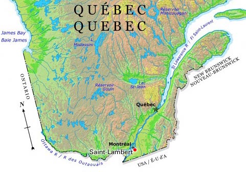
-
Article
Saint-Luc
Saint-Luc was named by association with the neighbouring parishes of St-Martin and St-Marc. In 1963 it incorporated as the city of Saint-Luc with a population of 3218. Eel fishing was one of the mainstays of the economy. This industry remains part of present-day Saint-Luc.
"https://d2ttikhf7xbzbs.cloudfront.net/media/media/3a3e45fe-9cf1-4f08-ae79-06c5f7df3f4f.jpg" // resources/views/front/categories/view.blade.php
https://d2ttikhf7xbzbs.cloudfront.net/media/media/3a3e45fe-9cf1-4f08-ae79-06c5f7df3f4f.jpg
-
Article
Saint-Nicolas
Saint-Nicolas, Quebec, population 23,675 (2019), 16,645 (2001 census). The city of Saint-Nicolas was originally incorporated in 1994 with the amalgamation of the municipalities of Bernières and Saint-Nicolas. Since 2002, Saint-Nicolas is part of the city of Lévis. Saint-Nicolas is located 17 km southwest of Quebec City. Saint-Nicolas is on the south shore of the St. Lawrence River and to the west of Rivière Chaudière. It is a thriving residential suburb of Quebec City. The area is linked to the city of Sainte-Foy, on the opposite shore of the St. Lawrence, by the Pierre-Laporte suspension bridge and the old, cantilever Quebec Bridge. (See also Quebec Bridge Disaster.)
"https://development.thecanadianencyclopedia.ca/images/tce_placeholder.jpg?v=e9dca980c9bdb3aa11e832e7ea94f5d9" // resources/views/front/categories/view.blade.php
https://development.thecanadianencyclopedia.ca/images/tce_placeholder.jpg?v=e9dca980c9bdb3aa11e832e7ea94f5d9