Browse "Districts and municipalities"
-
Article
Brossard
Brossard, Quebec, population 85,721 (2016 census), 79,273 (2011 census). Incorporated as a city in 1978, from 2002 to 2006 Brossard was a borough of Longueuil. Longueil was created by the amalgamation of eight distinct municipalities, including Brossard. In a 2004 referendum, Brossard residents voted to reconstitute their city. In 2006, Brossard again became its own municipality. Brossard is located on the South Shore of the St. Lawrence River, a short distance from the Champlain Bridge that links it to Montreal.
"https://development.thecanadianencyclopedia.ca/images/tce_placeholder.jpg?v=e9dca980c9bdb3aa11e832e7ea94f5d9" // resources/views/front/categories/view.blade.php
https://development.thecanadianencyclopedia.ca/images/tce_placeholder.jpg?v=e9dca980c9bdb3aa11e832e7ea94f5d9
-
Article
Buckland
Buckland, Sask, incorporated as a rural municipality in 1911, population 3658 (2011c), 3429 (2006c). The Rural Municipality of Buckland is named for the deer that were once common in the area.
"https://development.thecanadianencyclopedia.ca/images/tce_placeholder.jpg?v=e9dca980c9bdb3aa11e832e7ea94f5d9" // resources/views/front/categories/view.blade.php
https://development.thecanadianencyclopedia.ca/images/tce_placeholder.jpg?v=e9dca980c9bdb3aa11e832e7ea94f5d9
-
Article
Cabbagetown
Cabbagetown, a district in east-central Toronto, the general boundaries of which are the Don River on the east, Parliament St on the west, Gerrard St on the north, and Queen St on the south.
"https://development.thecanadianencyclopedia.ca/images/tce_placeholder.jpg?v=e9dca980c9bdb3aa11e832e7ea94f5d9" // resources/views/front/categories/view.blade.php
https://development.thecanadianencyclopedia.ca/images/tce_placeholder.jpg?v=e9dca980c9bdb3aa11e832e7ea94f5d9
-
Article
Cantley
The first to settle the Cantley area were of Scottish or English origin. Andrew Blackburn and his 2 sons arrived in 1829. Colonel Cantley, a British army officer who had worked on the RIDEAU CANAL with Colonel John By, was granted land in what was to become Cantley in the early 1830s.
"https://d2ttikhf7xbzbs.cloudfront.net/media/media/3242ae12-3c51-4a40-ab91-d870c6d8439e.jpg" // resources/views/front/categories/view.blade.php
https://d2ttikhf7xbzbs.cloudfront.net/media/media/3242ae12-3c51-4a40-ab91-d870c6d8439e.jpg
-
Article
Canwood
In 1954 Canwood was tripled in size when the former RM of Shell Lake and several improvement districts were added to the community. The current size of the RM is almost 25 townships. Most of the people in the area are engaged in agriculture, with grain farming and livestock the major products.
"https://d2ttikhf7xbzbs.cloudfront.net/media/media/a701f450-902b-410d-b101-e35a0bcf8ce2.jpg" // resources/views/front/categories/view.blade.php
https://d2ttikhf7xbzbs.cloudfront.net/media/media/a701f450-902b-410d-b101-e35a0bcf8ce2.jpg
-
Article
Cape Breton Regional Municipality
Cape Breton, incorporated as a regional municipality in 1995, population 97 398 (2011c), 102 250 (2006c). The Cape Breton Regional Municipality is located on the eastern extremity of CAPE BRETON ISLAND.
"https://development.thecanadianencyclopedia.ca/images/tce_placeholder.jpg?v=e9dca980c9bdb3aa11e832e7ea94f5d9" // resources/views/front/categories/view.blade.php
https://development.thecanadianencyclopedia.ca/images/tce_placeholder.jpg?v=e9dca980c9bdb3aa11e832e7ea94f5d9
-
Article
Central Saanich
Central Saanich, BC, incorporated as a district municipality in 1950, population 15 936 (2011c), 15 745 (2006c). The District of Central Saanich is one of three district municipalities located on the SAANICH PENINSULA, about 21 km north of VICTORIA.
"https://development.thecanadianencyclopedia.ca/images/tce_placeholder.jpg?v=e9dca980c9bdb3aa11e832e7ea94f5d9" // resources/views/front/categories/view.blade.php
https://development.thecanadianencyclopedia.ca/images/tce_placeholder.jpg?v=e9dca980c9bdb3aa11e832e7ea94f5d9
-
Article
Chatham-Kent
Chatham-Kent, ON, incorporated as a municipality in 1998, population 103,988 (2021 census), 101,647 (2016 census). The Municipality of Chatham-Kent is located on the Thames River, 80 km east of Windsor. The City of Chatham (incorporated 1895) and Kent County (created 1792) are just two of the 23 former municipalities that comprise Chatham-Kent. Others include the towns of Wallaceburg, Blenheim, Tilbury, Ridgetown and Dresden. This large municipality is bounded by lakes St. Clair and Erie (to its west and east), with the lower Thames River running down its length.
"https://development.thecanadianencyclopedia.ca/images/tce_placeholder.jpg?v=e9dca980c9bdb3aa11e832e7ea94f5d9" // resources/views/front/categories/view.blade.php
https://development.thecanadianencyclopedia.ca/images/tce_placeholder.jpg?v=e9dca980c9bdb3aa11e832e7ea94f5d9
-
Article
Chesterville
Chesterville, Ont, urban area, population 1514 (2011c), 1528 (2006c). Chesterville is a community located 64 km southeast of OTTAWA, 30 km north of the St Lawrence River on the South Nation River.
"https://d2ttikhf7xbzbs.cloudfront.net/media/media/b18f13d1-4308-449e-91ee-6ba36a91b8c5.jpg" // resources/views/front/categories/view.blade.php
https://d2ttikhf7xbzbs.cloudfront.net/media/media/b18f13d1-4308-449e-91ee-6ba36a91b8c5.jpg
-
Article
Chetwynd
Chetwynd, BC, incorporated as a district municipality in 1983, population 2635 (2011c), 2633 (2006c). The District of Chetwynd is located in the valley of the Pine River near Pine Pass to the west, in the northeast corner of British Columbia, 310 km north of PRINCE GEORGE.
"https://development.thecanadianencyclopedia.ca/images/tce_placeholder.jpg?v=e9dca980c9bdb3aa11e832e7ea94f5d9" // resources/views/front/categories/view.blade.php
https://development.thecanadianencyclopedia.ca/images/tce_placeholder.jpg?v=e9dca980c9bdb3aa11e832e7ea94f5d9
-
Article
Clarington
Clarington, Ontario, incorporated as a municipality in 1974, population 84 548 (2011c), 77 820 (2006c). The Municipality of Clarington is located on the north shore of Lake Ontario 80 km east of Toronto within the Regional Municipality of Durham.
"https://development.thecanadianencyclopedia.ca/images/tce_placeholder.jpg?v=e9dca980c9bdb3aa11e832e7ea94f5d9" // resources/views/front/categories/view.blade.php
https://development.thecanadianencyclopedia.ca/images/tce_placeholder.jpg?v=e9dca980c9bdb3aa11e832e7ea94f5d9
-
Article
Coldstream
Coldstream, BC, incorporated as a district municipality in 1906, population 10 314 (2011c), 9471 (2006c). The District of Coldstream lies in the valley of Coldstream Creek, about two kilometres southeast of VERNON. Captain Charles F.
"https://development.thecanadianencyclopedia.ca/images/tce_placeholder.jpg?v=e9dca980c9bdb3aa11e832e7ea94f5d9" // resources/views/front/categories/view.blade.php
https://development.thecanadianencyclopedia.ca/images/tce_placeholder.jpg?v=e9dca980c9bdb3aa11e832e7ea94f5d9
-
Article
Contrecoeur
Contrecoeur was one of the first French establishments in North America. It was founded as the seigneurie de Contrecoeur in 1667 by Sieur Antoine Pécaudy de Contrecoeur, captain of the Carignan-Salières regiment. Antoine Pécaudy de Contrecoeur was born in 1596, at Vignieu en Dauphiné, France.
"https://d2ttikhf7xbzbs.cloudfront.net/media/media/d23eab8c-4936-4d32-86d2-e499a33db129.jpg" // resources/views/front/categories/view.blade.php
https://d2ttikhf7xbzbs.cloudfront.net/media/media/d23eab8c-4936-4d32-86d2-e499a33db129.jpg
-
Article
Crowsnest Pass (Alta)
Crowsnest Pass, Alta, incorporated as a municipality in 2008, population 5565 (2011c), 6261 (2006c). The Municipality of Crowsnest Pass is located 269 km southwest of Calgary in the historic CROWSNEST PASS through the Rocky Mountains. The municipality takes its name from a prominent nearby mountain.
"https://d2ttikhf7xbzbs.cloudfront.net/media/media/a9ba436e-b7bf-4c60-be8f-304e450dbf4f.jpg" // resources/views/front/categories/view.blade.php
https://d2ttikhf7xbzbs.cloudfront.net/media/media/a9ba436e-b7bf-4c60-be8f-304e450dbf4f.jpg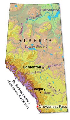
-
Article
Dartmouth
Dartmouth, Nova Scotia, metropolitan area, population (including Cole Harbour) 96,165 (2021 census), 92,301 (2016 census). Dartmouth is located on the eastern side of Halifax Harbour in the Halifax Regional Municipality (incorporated in 1996).
"https://d2ttikhf7xbzbs.cloudfront.net/media/media/09ef6dac-263c-4515-92b7-f062849a532b.jpg" // resources/views/front/categories/view.blade.php
https://d2ttikhf7xbzbs.cloudfront.net/media/media/09ef6dac-263c-4515-92b7-f062849a532b.jpg