Browse "Districts and municipalities"
-
Article
Maple Ridge
Maple Ridge, BC, incorporated as a district municipality in 1874, population 76 052 (2011c), 68 949 (2006c). The District of Maple Ridge is located 40 km east of VANCOUVER, bounded by the FRASER RIVER on the south and on the north by the Golden Ears Mountain.
"https://development.thecanadianencyclopedia.ca/images/tce_placeholder.jpg?v=e9dca980c9bdb3aa11e832e7ea94f5d9" // resources/views/front/categories/view.blade.php
https://development.thecanadianencyclopedia.ca/images/tce_placeholder.jpg?v=e9dca980c9bdb3aa11e832e7ea94f5d9
-
Article
Matsqui
Matsqui, BC, Urban Community, was a district municipality (1892-1995) until it was merged with the District Municipality of Abbotsford to form the city of ABBOTSFORD. Matsqui is located between the FRASER RIVER (opposite the district of MISSION) and the US border.
"https://development.thecanadianencyclopedia.ca/images/tce_placeholder.jpg?v=e9dca980c9bdb3aa11e832e7ea94f5d9" // resources/views/front/categories/view.blade.php
https://development.thecanadianencyclopedia.ca/images/tce_placeholder.jpg?v=e9dca980c9bdb3aa11e832e7ea94f5d9
-
Article
Meaford
Meaford, Ont, incorporated as a municipality in 2001, population 11 100 (2011c) 10 948 (2006c). The Municipality of Meaford was a town (incorporated in 1874) until 2001 when it was amalgamated with St Vincent and Sydenham townships to create the Municipality of Meaford
"https://d2ttikhf7xbzbs.cloudfront.net/media/media/2fa20b37-d822-4528-b9b5-d99acf454bfc.jpg" // resources/views/front/categories/view.blade.php
https://d2ttikhf7xbzbs.cloudfront.net/media/media/2fa20b37-d822-4528-b9b5-d99acf454bfc.jpg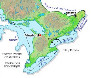
-
Article
Metchosin
Metchosin, British Columbia, incorporated as a district municipality in 1984, population 4,708 (2016 census), 4,803 (2011 census). The District of Metchosin is located on Vancouver Island. It overlooks the Juan de Fuca Strait. Metchosin is part of the Greater Victoria area. From the late 1800s to 1958, a quarantine station operated at William Head in Metchosin. Many immigrants arriving to Canada by ship were quarantined at William Head before being allowed to enter the country. This was done in an effort to prevent the spread of infectious diseases common on overcrowded ships. In addition, from 1924 to 1956, there was a leper colony on nearby Bentinck Island.
"https://d2ttikhf7xbzbs.cloudfront.net/media/media/853b5d41-e9b6-4b2e-a205-03a54f80d5b2.jpg" // resources/views/front/categories/view.blade.php
https://d2ttikhf7xbzbs.cloudfront.net/media/media/853b5d41-e9b6-4b2e-a205-03a54f80d5b2.jpg
-
Article
Mission
Mission, BC, incorporated as a district municipality in 1969, population 36 426 (2011c), 34 505 (2006c). The District of Mission is located on the north bank ofthe FRASER RIVER, 70 km by road east of VANCOUVER.
"https://d2ttikhf7xbzbs.cloudfront.net/media/media/6232f070-823a-44e3-8285-5bb9d14cf197.jpg" // resources/views/front/categories/view.blade.php
https://d2ttikhf7xbzbs.cloudfront.net/media/media/6232f070-823a-44e3-8285-5bb9d14cf197.jpg
-
Article
Mistassini
Mistassini, Qué, was a separate municipality (inc 1976) until it merged with Dolbeau to form the city of Dolbeau-Mistassini.
"https://development.thecanadianencyclopedia.ca/images/tce_placeholder.jpg?v=e9dca980c9bdb3aa11e832e7ea94f5d9" // resources/views/front/categories/view.blade.php
https://development.thecanadianencyclopedia.ca/images/tce_placeholder.jpg?v=e9dca980c9bdb3aa11e832e7ea94f5d9
-
Article
Muskoka
District Municipality of Muskoka, Ontario, incorporated in 1971, permanent population 66,674 (2021 census), 60,614 (2016 census); estimated seasonal population 85,163 (2016). Muskoka is an iconic area of Ontario’s cottage country located approximately 200 km north of Toronto. A destination for seasonal residents and tourists who have been drawn by its natural beauty since the late 1800s, the district has equally been home to generations of permanent residents.
"https://d2ttikhf7xbzbs.cloudfront.net/media/media/b38374d2-1aa9-48ab-a86b-276b8da208de.jpg" // resources/views/front/categories/view.blade.php
https://d2ttikhf7xbzbs.cloudfront.net/media/media/b38374d2-1aa9-48ab-a86b-276b8da208de.jpg
-
Article
Norfolk County
Norfolk County, Ont, incorporated as a city in 2001, population 63 175 (2011c), 62 563 (2006c). The City of Norfolk County is located 56 km southwest of Hamilton and 97 km southeast of London.
"https://d2ttikhf7xbzbs.cloudfront.net/media/media/6928ba8e-68f0-4309-a242-259e8cc1000b.jpg" // resources/views/front/categories/view.blade.php
https://d2ttikhf7xbzbs.cloudfront.net/media/media/6928ba8e-68f0-4309-a242-259e8cc1000b.jpg
-
Article
North Cowichan
North Cowichan, BC, incorporated as a district municipality in 1873, population 28 807 (2011c), 27 557 (2006c). The Municipality of North Cowichan is located on the east coast of VANCOUVER ISLAND about halfway between Nanaimo and Victoria.
"https://d2ttikhf7xbzbs.cloudfront.net/media/media/ce2915be-f93b-4a88-b0e0-316d5c6a246f.jpg" // resources/views/front/categories/view.blade.php
https://d2ttikhf7xbzbs.cloudfront.net/media/media/ce2915be-f93b-4a88-b0e0-316d5c6a246f.jpg
-
Article
North Saanich
North Saanich, BC, incorporated as a district municipality in 1965, population 11 089 (2011c), 10 823 (2006c). The District of North Saanich is one of three district municipalities on the Saanich Peninsula about 27 km north of Victoria.
"https://d2ttikhf7xbzbs.cloudfront.net/media/media/dee732ba-3897-4661-8537-d19601c1bfee.jpg" // resources/views/front/categories/view.blade.php
https://d2ttikhf7xbzbs.cloudfront.net/media/media/dee732ba-3897-4661-8537-d19601c1bfee.jpg
-
Article
North Vancouver
North Vancouver, British Columbia, incorporated as a district in 1891, population 85,935 (2016 census), 84,412 (2011 census); also, a separate entity incorporated as a city in 1907, population 52,898 (2016 census), 48,196 (2011 census). The district of North Vancouver and the city of North Vancouver are located in southwestern British Columbia, adjacent to the city of Vancouver. Situated on the north shore of Burrard Inlet, North Vancouver extends from the Capilano River on the west to beyond Deep Cove on the east. The district surrounds the city, which is centered on Lonsdale Avenue, except at the waterfront. Elevations in North Vancouver range from sea level to 1,400 metres. The North Shore mountains — such as Grouse and Seymour — form a scenic backdrop.
"https://d2ttikhf7xbzbs.cloudfront.net/media/new_article_images/NorthVancouver/North Vancouver_2016.jpg" // resources/views/front/categories/view.blade.php
https://d2ttikhf7xbzbs.cloudfront.net/media/new_article_images/NorthVancouver/North Vancouver_2016.jpg
-
Article
Oak Bay
Oak Bay, incorporated as a district municipality in 1906, population 18 015 (2011c), 17 908 (2006c). The District of Oak Bay is located on the southeast corner of VANCOUVER ISLAND, adjoining the city of VICTORIA. It is surrounded by JUAN DE FUCA STRAIT on the south and Haro Strait on the east.
"https://development.thecanadianencyclopedia.ca/images/tce_placeholder.jpg?v=e9dca980c9bdb3aa11e832e7ea94f5d9" // resources/views/front/categories/view.blade.php
https://development.thecanadianencyclopedia.ca/images/tce_placeholder.jpg?v=e9dca980c9bdb3aa11e832e7ea94f5d9
-
"https://d2ttikhf7xbzbs.cloudfront.net/media/media/af36926e-717c-45ef-91cc-f00a20c1faeb.jpg" // resources/views/front/categories/view.blade.php
https://d2ttikhf7xbzbs.cloudfront.net/media/media/af36926e-717c-45ef-91cc-f00a20c1faeb.jpg
-
Article
Orkney
Since 1926 the Rural Municipality of Orkney has had a joint administration with the neighbouring rural municipality of Wallace. There are 2 communities in the rural municipality, Orcadia, a stop on the Canadian Pacific Railway line and White Spruce.
"https://d2ttikhf7xbzbs.cloudfront.net/media/media/70457afb-6f7d-4316-b6b4-db43541c3e08.jpg" // resources/views/front/categories/view.blade.php
https://d2ttikhf7xbzbs.cloudfront.net/media/media/70457afb-6f7d-4316-b6b4-db43541c3e08.jpg
-
Article
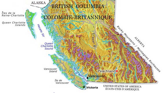
Peachland
Peachland, BC, incorporated as a district municipality in 1909, population 5200 (2011c), 4883 (2006c). The District of Peachland is located on the west shore of OKANAGAN LAKE, 25 km south of KELOWNA.
"https://d2ttikhf7xbzbs.cloudfront.net/media/media/ee63257d-2328-4e59-914e-6e496c640a51.jpg" // resources/views/front/categories/view.blade.php
https://d2ttikhf7xbzbs.cloudfront.net/media/media/ee63257d-2328-4e59-914e-6e496c640a51.jpg