Browse "Cities & Populated Places"
-
Article
Lacombe
Lacombe, Alta, incorporated as a town in 1902 and as a city in 2010, population 11 707 (2011c), 10 752 (2006c). The City of Lacombe, the county seat for the County of Lacombe, is situated in rolling parkland some 118 km south of Edmonton.
"https://development.thecanadianencyclopedia.ca/images/tce_placeholder.jpg?v=e9dca980c9bdb3aa11e832e7ea94f5d9" // resources/views/front/categories/view.blade.php
https://development.thecanadianencyclopedia.ca/images/tce_placeholder.jpg?v=e9dca980c9bdb3aa11e832e7ea94f5d9
-
Article
Ladysmith
Ladysmith, BC, incorporated as a town in 1904, population 7921 (2011c), 7538 (2006c). The Town of Ladysmith is located on the east coast of VANCOUVER ISLAND, 85 km north of Victoria. It is located on Ladysmith Harbour on the northern edge of a lucrative farming area.
"https://development.thecanadianencyclopedia.ca/images/tce_placeholder.jpg?v=e9dca980c9bdb3aa11e832e7ea94f5d9" // resources/views/front/categories/view.blade.php
https://development.thecanadianencyclopedia.ca/images/tce_placeholder.jpg?v=e9dca980c9bdb3aa11e832e7ea94f5d9
-
Article
Lake Cowichan
Lake Cowichan, BC, incorporated as a town in 1996, population 2974 (2011c), 3012 (2006c). The Town of Lake Cowichan is located adjacent to the Cowichan River and Cowichan Lake on southern VANCOUVER ISLAND, 26 km west of DUNCAN.
"https://d2ttikhf7xbzbs.cloudfront.net/media/media/7c173143-b064-437c-9ca5-29f626b53c24.jpg" // resources/views/front/categories/view.blade.php
https://d2ttikhf7xbzbs.cloudfront.net/media/media/7c173143-b064-437c-9ca5-29f626b53c24.jpg
-
Article
L'Ancienne-Lorette
The history of L'Ancienne-Lorette goes back to 1674, when the Jesuit Pierre Chaumonot (1611-93) built a chapel on this site for the HURONS who had been forced to flee their homeland (Ontario) by the Iroquois.
"https://development.thecanadianencyclopedia.ca/images/tce_placeholder.jpg?v=e9dca980c9bdb3aa11e832e7ea94f5d9" // resources/views/front/categories/view.blade.php
https://development.thecanadianencyclopedia.ca/images/tce_placeholder.jpg?v=e9dca980c9bdb3aa11e832e7ea94f5d9
-
Article
Langley
Langley, BC, incorporated as a district municipality in 1873, population 104 177 (2011c), 93 726 (2006c). The Township of Langley is located about 40 km east of VANCOUVER. The city of Langley, population 25 081 (2011c), 23 606 (2006c), became a separate municipality in 1955.
"https://development.thecanadianencyclopedia.ca/images/tce_placeholder.jpg?v=e9dca980c9bdb3aa11e832e7ea94f5d9" // resources/views/front/categories/view.blade.php
https://development.thecanadianencyclopedia.ca/images/tce_placeholder.jpg?v=e9dca980c9bdb3aa11e832e7ea94f5d9
-
Article
LaSalle
History In 1667, René-Robert Cavelier de la Salle became seigneur of the land of present-day LaSalle. In order to avoid the Lachine Rapids, traders, explorers and Indigenous people portaged along a path that would become LaSalle Boulevard.
"https://d2ttikhf7xbzbs.cloudfront.net/media/media/c26e0d11-ffaa-4f9e-beae-00eff688b6b6.jpg" // resources/views/front/categories/view.blade.php
https://d2ttikhf7xbzbs.cloudfront.net/media/media/c26e0d11-ffaa-4f9e-beae-00eff688b6b6.jpg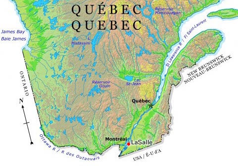
-
Article
L'Assomption
L'Assomption, Québec, incorporated as a city in 1992, population 20,065 (2011 c), 16,738 (2006 c).
"https://development.thecanadianencyclopedia.ca/images/tce_placeholder.jpg?v=e9dca980c9bdb3aa11e832e7ea94f5d9" // resources/views/front/categories/view.blade.php
https://development.thecanadianencyclopedia.ca/images/tce_placeholder.jpg?v=e9dca980c9bdb3aa11e832e7ea94f5d9
-
Article
Laterrière
The name was first applied to the township (1850) and then the parish (1882). They were named after Marc-Pascal de Sales Laterrière, who represented Saguenay in the Legislative Assembly of the Province of Canada.
"https://d2ttikhf7xbzbs.cloudfront.net/media/media/b129fc4e-8039-4ddb-b986-6065a9b74dc1.jpg" // resources/views/front/categories/view.blade.php
https://d2ttikhf7xbzbs.cloudfront.net/media/media/b129fc4e-8039-4ddb-b986-6065a9b74dc1.jpg
-
Article
Laurentian Hills
Laurentian Hills, Ont, incorporated as a town in 2000, population 2811 (2011c), 2789 (2006c). The Town of Laurentian Hills is located close to the Ottawa River, about 210 km northwest of Ottawa. The town came into existence with
"https://development.thecanadianencyclopedia.ca/images/tce_placeholder.jpg?v=e9dca980c9bdb3aa11e832e7ea94f5d9" // resources/views/front/categories/view.blade.php
https://development.thecanadianencyclopedia.ca/images/tce_placeholder.jpg?v=e9dca980c9bdb3aa11e832e7ea94f5d9
-
Article
Laval
Laval, Quebec, incorporated as a city in 1965, population 438,366 (2021 census), 422,993 (2016 census). Laval was formed by the merger of 14 municipalities: Chomedey, Duvernay, Laval-des-Rapides, Laval-Ouest, Pont-Viau, Sainte-Rose, Auteuil, Fabreville, Îles-Laval, Laval-sur-le-lac, Sainte-Dorothée, Saint-François, Saint-Vincent-de-Paul and Vimont. Laval is the third largest city in Quebec. It is located on Île Jésus, north of Île de Montréal. Laval is separated from Île de Montréal by the Rivière des Prairies and from the mainland to the north by the Rivière des Mille Îles. The city is named after François de Laval, the first Roman Catholic bishop of Quebec (1674-88) and onetime seigneur (1675-80) of Île Jésus.
"https://development.thecanadianencyclopedia.ca/images/tce_placeholder.jpg?v=e9dca980c9bdb3aa11e832e7ea94f5d9" // resources/views/front/categories/view.blade.php
https://development.thecanadianencyclopedia.ca/images/tce_placeholder.jpg?v=e9dca980c9bdb3aa11e832e7ea94f5d9
-
Article
Le Gardeur
First set up as the parish municipality of Saint-Paul-l'Ermite in 1857, it was incorporated as a city under the same name in 1973 before changing its designation to Le Gardeur in 1978.
"https://development.thecanadianencyclopedia.ca/images/tce_placeholder.jpg?v=e9dca980c9bdb3aa11e832e7ea94f5d9" // resources/views/front/categories/view.blade.php
https://development.thecanadianencyclopedia.ca/images/tce_placeholder.jpg?v=e9dca980c9bdb3aa11e832e7ea94f5d9
-
Article
Leaf Rapids
Leaf Rapids, Manitoba, incorporated as a town in 1974, population 453 (2011c), 539 (2006c). The Town of Leaf Rapids is a mining community located 3 km south of the CHURCHILL RIVER on the Canadian Shield and 976 km northwest of Winnipeg.
"https://development.thecanadianencyclopedia.ca/images/tce_placeholder.jpg?v=e9dca980c9bdb3aa11e832e7ea94f5d9" // resources/views/front/categories/view.blade.php
https://development.thecanadianencyclopedia.ca/images/tce_placeholder.jpg?v=e9dca980c9bdb3aa11e832e7ea94f5d9
-
Article
Leamington
Leamington, Ont, incorporated as a town in 1890 and as a municipality in 1999, population 28 403 (2011c), 28 833 (2006c). The Municipality of Leamington is located on the north shore of LAKE ERIE, 54 km southeast of WINDSOR.
"https://development.thecanadianencyclopedia.ca/images/tce_placeholder.jpg?v=e9dca980c9bdb3aa11e832e7ea94f5d9" // resources/views/front/categories/view.blade.php
https://development.thecanadianencyclopedia.ca/images/tce_placeholder.jpg?v=e9dca980c9bdb3aa11e832e7ea94f5d9
-
Article
Leduc
Leduc, Alta, incorporated as a town in 1906 and as a city in 1983, population 24 279 (2011c), 16 967 (2006c). The City of Leduc is located 30 km south of EDMONTON. Originally a telegraph terminus and stop on the Calgary and Edmonton Railway (1891), the community grew as an agricultural centre.
"https://d2ttikhf7xbzbs.cloudfront.net/media/media/44470b4c-f3a6-43c4-b226-5b07849fd3f2.jpg" // resources/views/front/categories/view.blade.php
https://d2ttikhf7xbzbs.cloudfront.net/media/media/44470b4c-f3a6-43c4-b226-5b07849fd3f2.jpg
-
Article
Lennoxville
The Abenaki and the French missionaries often used the site because it was a focal point for canoes and small boats using the tributaries of the Saint-François. A sawmill and forest products plant (lumber and potash) preceded the founding of the first village by LOYALISTS around 1794.
"https://development.thecanadianencyclopedia.ca/images/tce_placeholder.jpg?v=e9dca980c9bdb3aa11e832e7ea94f5d9" // resources/views/front/categories/view.blade.php
https://development.thecanadianencyclopedia.ca/images/tce_placeholder.jpg?v=e9dca980c9bdb3aa11e832e7ea94f5d9