Browse "Coastal Regions"
-
Article
LaHave River Estuary
LaHave River Estuary is a narrow, shallow inlet of the Atlantic Ocean extending 24 km from Bridgewater, NS, to the coast.
"https://development.thecanadianencyclopedia.ca/images/tce_placeholder.jpg?v=e9dca980c9bdb3aa11e832e7ea94f5d9" // resources/views/front/categories/view.blade.php
https://development.thecanadianencyclopedia.ca/images/tce_placeholder.jpg?v=e9dca980c9bdb3aa11e832e7ea94f5d9
-
Article
Lancaster Sound
Lancaster Sound, an arm of Baffin Bay and a major passage through the Arctic Archipelago, is 400 km long and some 100 km wide.
"https://development.thecanadianencyclopedia.ca/images/tce_placeholder.jpg?v=e9dca980c9bdb3aa11e832e7ea94f5d9" // resources/views/front/categories/view.blade.php
https://development.thecanadianencyclopedia.ca/images/tce_placeholder.jpg?v=e9dca980c9bdb3aa11e832e7ea94f5d9
-
Article
Malpeque Bay
Malpeque Bay is a picturesque bay so deeply indented into the northeast coast of Prince Edward Island that its southern edge lies within 7 km of the south coast of the Island.
"https://development.thecanadianencyclopedia.ca/images/tce_placeholder.jpg?v=e9dca980c9bdb3aa11e832e7ea94f5d9" // resources/views/front/categories/view.blade.php
https://development.thecanadianencyclopedia.ca/images/tce_placeholder.jpg?v=e9dca980c9bdb3aa11e832e7ea94f5d9
-
Article
Metlakatla Pass Area
Metlakatla Pass, or Venn Passage, is located 4 km west of Prince Rupert on the northern BC coast.
"https://development.thecanadianencyclopedia.ca/images/tce_placeholder.jpg?v=e9dca980c9bdb3aa11e832e7ea94f5d9" // resources/views/front/categories/view.blade.php
https://development.thecanadianencyclopedia.ca/images/tce_placeholder.jpg?v=e9dca980c9bdb3aa11e832e7ea94f5d9
-
Article
Minas Basin
Minas Basin is the broadest part of the south-eastern head of the Bay of FUNDY and lies entirely within Nova Scotia. It merges westward into Fundy, through Minas Channel, 5 km wide, and eastward into Cobequid Bay, and is widest (30 km) south of Parrsboro, Nova Scotia.
"https://d2ttikhf7xbzbs.cloudfront.net/media/media/be636a29-f69f-4cdf-b060-f5c1dba7c65e.jpg" // resources/views/front/categories/view.blade.php
https://d2ttikhf7xbzbs.cloudfront.net/media/media/be636a29-f69f-4cdf-b060-f5c1dba7c65e.jpg
-
Article
Nootka Sound
Nootka Sound, British Columbia, is an inlet on Vancouver Island's western coast, 270 km northwest of Victoria. This area is known for its natural beauty.
"https://d2ttikhf7xbzbs.cloudfront.net/nootkasound/Bligh-Island-Nootka-Sound.jpg" // resources/views/front/categories/view.blade.php
https://d2ttikhf7xbzbs.cloudfront.net/nootkasound/Bligh-Island-Nootka-Sound.jpg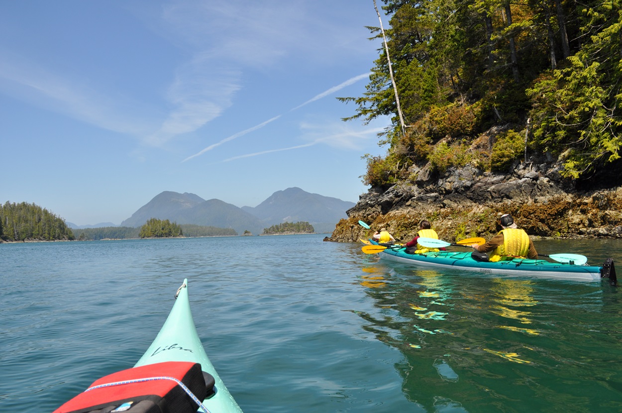
-
Article
North Cape
North Cape, also called North Port, is the northern extremity of Prince Edward Island, dividing Northumberland Strait from the Gulf of St Lawrence proper.
"https://development.thecanadianencyclopedia.ca/images/tce_placeholder.jpg?v=e9dca980c9bdb3aa11e832e7ea94f5d9" // resources/views/front/categories/view.blade.php
https://development.thecanadianencyclopedia.ca/images/tce_placeholder.jpg?v=e9dca980c9bdb3aa11e832e7ea94f5d9
-
Article
Northumberland Strait
A generally shallow depth causes strong tidal currents, water turbulence and a high concentration of suspended red silt and clay, which led early French colonists to name the strait "la mer rouge.
"https://d2ttikhf7xbzbs.cloudfront.net/media/media/d2e73a66-567c-4b92-ab82-e34c1cba8a41.jpg" // resources/views/front/categories/view.blade.php
https://d2ttikhf7xbzbs.cloudfront.net/media/media/d2e73a66-567c-4b92-ab82-e34c1cba8a41.jpg
-
Article
Northwest Passage
The Northwest Passage is a sea corridor through Canada's Arctic archipelago and along the northern coast of North America. European explorers searched in vain for the passage for 300 years, intent on finding a commercially viable western sea route between Europe and Asia.
"https://d2ttikhf7xbzbs.cloudfront.net/media/media/acca04c0-f3cc-448d-b29a-0b7dbefd6ade.jpg" // resources/views/front/categories/view.blade.php
https://d2ttikhf7xbzbs.cloudfront.net/media/media/acca04c0-f3cc-448d-b29a-0b7dbefd6ade.jpg
-
Article
Notre Dame Bay
Notre Dame Bay, 6000 km 2 , is a large inlet of the Atlantic Ocean on the northeast coast of Newfoundland. It contains many islands and its shores are indented by numerous coves and smaller embayments. One of Newfoundland's
"https://d2ttikhf7xbzbs.cloudfront.net/media/media/12671f6f-b61d-4d19-a9f7-d6c43ef0496c.jpg" // resources/views/front/categories/view.blade.php
https://d2ttikhf7xbzbs.cloudfront.net/media/media/12671f6f-b61d-4d19-a9f7-d6c43ef0496c.jpg
-
Article
Pacific Rim
The term Pacific Rim has been used to refer to all those countries with coastlines bordering the Pacific Ocean. However, in recent years the term has become synonymous with the Asia Pacific region which encompasses East and Southeast Asia, South Asia, Australia, New Zealand and North America.
"https://development.thecanadianencyclopedia.ca/images/tce_placeholder.jpg?v=e9dca980c9bdb3aa11e832e7ea94f5d9" // resources/views/front/categories/view.blade.php
https://development.thecanadianencyclopedia.ca/images/tce_placeholder.jpg?v=e9dca980c9bdb3aa11e832e7ea94f5d9
-
Article
Parry Channel
Parry Channel is a sea passage running east to west through the arctic islands.
"https://development.thecanadianencyclopedia.ca/images/tce_placeholder.jpg?v=e9dca980c9bdb3aa11e832e7ea94f5d9" // resources/views/front/categories/view.blade.php
https://development.thecanadianencyclopedia.ca/images/tce_placeholder.jpg?v=e9dca980c9bdb3aa11e832e7ea94f5d9
-
Article
Passamaquoddy Bay
Passamaquoddy Bay is a small inlet near the mouth of the Bay of Fundy. Its mouth is restricted by a chain of islands, including Deer and Campobello, and strong tides (range 8.3 m) prevail in the region.
"https://development.thecanadianencyclopedia.ca/images/tce_placeholder.jpg?v=e9dca980c9bdb3aa11e832e7ea94f5d9" // resources/views/front/categories/view.blade.php
https://development.thecanadianencyclopedia.ca/images/tce_placeholder.jpg?v=e9dca980c9bdb3aa11e832e7ea94f5d9
-
Article
Placentia Bay
Placentia Bay, from the French plaisance (meaning a "pleasant place"), is a large, deep bay formed by Newfoundland's Burin Peninsula to the west, and the southwestern Avalon Peninsula to the east.
"https://d2ttikhf7xbzbs.cloudfront.net/media/media/1156688e-36f0-43f0-b71a-c95ed49e88d0.jpg" // resources/views/front/categories/view.blade.php
https://d2ttikhf7xbzbs.cloudfront.net/media/media/1156688e-36f0-43f0-b71a-c95ed49e88d0.jpg
-
Article
Port Refuge
Port Refuge is a small bay on the south coast of Grinnell Peninsula, Devon I, in the high Arctic.
"https://development.thecanadianencyclopedia.ca/images/tce_placeholder.jpg?v=e9dca980c9bdb3aa11e832e7ea94f5d9" // resources/views/front/categories/view.blade.php
https://development.thecanadianencyclopedia.ca/images/tce_placeholder.jpg?v=e9dca980c9bdb3aa11e832e7ea94f5d9