Browse "Islands"
-
Article
Cape Sable Island
Cape Sable Island is a flat, wooded island off the southwestern tip of Nova Scotia. Connected to the mainland by a causeway on the north side, it shelters the waters of Barrington Bay to the east. The MIKMAQ hunted seals off Cape Sable Island.
"https://development.thecanadianencyclopedia.ca/images/tce_placeholder.jpg?v=e9dca980c9bdb3aa11e832e7ea94f5d9" // resources/views/front/categories/view.blade.php
https://development.thecanadianencyclopedia.ca/images/tce_placeholder.jpg?v=e9dca980c9bdb3aa11e832e7ea94f5d9
-
Article
Coats Island
Coats Island, Nunavut, 5,498 km2, is one of several islands that guard the northern entrance to Hudson Bay. Known originally as Cary Swan Nest, a name still applied to its southeast point, it received its modern name from William Coats, a sea captain who made many voyages into the bay for the Hudson's Bay Company between 1727 and 1751.
"https://d2ttikhf7xbzbs.cloudfront.net/media/media/853eb7cd-5eb0-46fe-b229-8f9b8b0136b4.jpg" // resources/views/front/categories/view.blade.php
https://d2ttikhf7xbzbs.cloudfront.net/media/media/853eb7cd-5eb0-46fe-b229-8f9b8b0136b4.jpg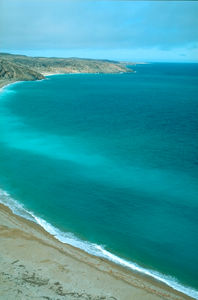
-
Article
Cormorant Island
Cormorant Island is a small, wooded island fringed with rock beaches close to the northeast coast of Vancouver Island. ALERT BAY, a fishing port and commercial centre for nearby logging communities, is located on its south shore. The island boasts some of the finest TOTEM POLES on the BC coast.
"https://development.thecanadianencyclopedia.ca/images/tce_placeholder.jpg?v=e9dca980c9bdb3aa11e832e7ea94f5d9" // resources/views/front/categories/view.blade.php
https://development.thecanadianencyclopedia.ca/images/tce_placeholder.jpg?v=e9dca980c9bdb3aa11e832e7ea94f5d9
-
Article
Cornwall Island
Cornwall Island, 2258 km2, located in the northern ARCTIC ARCHIPELAGO, some 100 km W of Ellesmere I. It is generally low, rising to a 375 m summit towards the W. The island was discovered in 1852 by Sir Edward BELCHER and named North Cornwall.
"https://development.thecanadianencyclopedia.ca/images/tce_placeholder.jpg?v=e9dca980c9bdb3aa11e832e7ea94f5d9" // resources/views/front/categories/view.blade.php
https://development.thecanadianencyclopedia.ca/images/tce_placeholder.jpg?v=e9dca980c9bdb3aa11e832e7ea94f5d9
-
Article
Cornwallis Island
Cornwallis Island, Nunavut, 6995 km2, is located between Bathurst Island and Devon Island in the Arctic Archipelago. It is separated from Somerset Island to the south by Barrow Strait. The island is generally flat, though there are prominent (400 m) cliffs along the east coast.
"https://d2ttikhf7xbzbs.cloudfront.net/media/media/4aad02e3-72bd-400c-87ab-d1380ccad4dc.jpg" // resources/views/front/categories/view.blade.php
https://d2ttikhf7xbzbs.cloudfront.net/media/media/4aad02e3-72bd-400c-87ab-d1380ccad4dc.jpg
-
Article
Deer Island
Deer Island abuts the border with the US at the entrance to Passamaquoddy Bay on the south coast of New Brunswick. Long in dispute with the US, sovereignty over the island passed to NB in 1817. The name is probably descriptive. Fishing is the most important economic activity.
"https://development.thecanadianencyclopedia.ca/images/tce_placeholder.jpg?v=e9dca980c9bdb3aa11e832e7ea94f5d9" // resources/views/front/categories/view.blade.php
https://development.thecanadianencyclopedia.ca/images/tce_placeholder.jpg?v=e9dca980c9bdb3aa11e832e7ea94f5d9
-
Article
Devon Island
The Truelove Lowland area of the island has diverse vegetation and wildlife, an abundance of soil water in the summer owing to blocked drainage, and greater precipitation and higher summer temperatures (4° to 8°C), with more clear days than other parts of the island.
"https://d2ttikhf7xbzbs.cloudfront.net/media/media/4aad02e3-72bd-400c-87ab-d1380ccad4dc.jpg" // resources/views/front/categories/view.blade.php
https://d2ttikhf7xbzbs.cloudfront.net/media/media/4aad02e3-72bd-400c-87ab-d1380ccad4dc.jpg
-
Article
Ellef Ringnes Island
Ellef Ringnes Island, 11 295 km2, is part of the SVERDRUP group that borders the Arctic Ocean. Most of the island consists of great thicknesses of sedimentary rock, except for an occurrence of the arctic coastal plain in the northwest corner.
"https://development.thecanadianencyclopedia.ca/images/tce_placeholder.jpg?v=e9dca980c9bdb3aa11e832e7ea94f5d9" // resources/views/front/categories/view.blade.php
https://development.thecanadianencyclopedia.ca/images/tce_placeholder.jpg?v=e9dca980c9bdb3aa11e832e7ea94f5d9
-
Article
Ellesmere Island
Ellesmere Island, at 196,236 km2, is the third-largest island in Canada, the 10th-largest island in the world and the most northerly island in the Arctic Archipelago. It is located in Nunavut and is separated from Greenland by Kane Basin and Kennedy Channel, and from Devon Island to the south by Jones Sound. Cape Columbia (83°06´ 41" N lat) is Canada's most northerly point of land.
"https://d2ttikhf7xbzbs.cloudfront.net/media/media/ef347593-f4c9-43ee-8904-fa9013524c1e.jpg" // resources/views/front/categories/view.blade.php
https://d2ttikhf7xbzbs.cloudfront.net/media/media/ef347593-f4c9-43ee-8904-fa9013524c1e.jpg
-
Article
Fishing Islands
Fishing Islands, an archipelago of about 15 islets in Lake Huron (scattered in an area of 10 km2), lie off the west coast of the Bruce Peninsula in western Ontario between Chiefs Point and Pike Bay.
"https://development.thecanadianencyclopedia.ca/images/tce_placeholder.jpg?v=e9dca980c9bdb3aa11e832e7ea94f5d9" // resources/views/front/categories/view.blade.php
https://development.thecanadianencyclopedia.ca/images/tce_placeholder.jpg?v=e9dca980c9bdb3aa11e832e7ea94f5d9
-
Article
Fogo Island
Fogo Island, Nfld, 254 km2, 15 km off Newfoundland's north-east coast, was named y do fogo, "fire island", by the Portuguese. The irregularly shaped island, heavily forested in the south, lies on shallow Fogo Shelf, which attracts salmon, cod and other species.
"https://development.thecanadianencyclopedia.ca/images/tce_placeholder.jpg?v=e9dca980c9bdb3aa11e832e7ea94f5d9" // resources/views/front/categories/view.blade.php
https://development.thecanadianencyclopedia.ca/images/tce_placeholder.jpg?v=e9dca980c9bdb3aa11e832e7ea94f5d9
-
Article
Funk Island
Funk Island, 25 ha, is a flat, 15 m high, wedge-shaped granite island 800 m by 400 m lying 60 km off Newfoundland's northeast coast, east of FOGO ISLAND. The origin of the name is unknown, though it may have been inspired by the smell of the guano that covers much of the island.
"https://development.thecanadianencyclopedia.ca/images/tce_placeholder.jpg?v=e9dca980c9bdb3aa11e832e7ea94f5d9" // resources/views/front/categories/view.blade.php
https://development.thecanadianencyclopedia.ca/images/tce_placeholder.jpg?v=e9dca980c9bdb3aa11e832e7ea94f5d9
-
Article
Galiano Island
Galiano Island, 5787 ha, is one of BC's GULF ISLANDS, named for Spanish navy commander Dionisio Alcalá-Galiano, who explored the area in 1792. It has the driest climate of the islands.
"https://development.thecanadianencyclopedia.ca/images/tce_placeholder.jpg?v=e9dca980c9bdb3aa11e832e7ea94f5d9" // resources/views/front/categories/view.blade.php
https://development.thecanadianencyclopedia.ca/images/tce_placeholder.jpg?v=e9dca980c9bdb3aa11e832e7ea94f5d9
-
Article
Grand Manan Island
With a population of about 2500 - chiefly in the villages of North Head, Grand Harbour and Seal Cove - its chief industries are scallops, herring, lobster and salmon aquaculture, dulse (seaweed) gathering and tourism.
"https://d2ttikhf7xbzbs.cloudfront.net/media/media/03d8b7c6-bc2b-4575-97ec-f3d453f5bf34.jpg" // resources/views/front/categories/view.blade.php
https://d2ttikhf7xbzbs.cloudfront.net/media/media/03d8b7c6-bc2b-4575-97ec-f3d453f5bf34.jpg
-
Article
Gulf Islands
Their bucolic charm, calm waters, rich bird and marine life and mild climate, in the driest zone on Canada's Pacific coast, have attracted homesteaders and cottagers since about 1859. Stands of tall timber growing in deep soil were logged early in this century.
"https://d2ttikhf7xbzbs.cloudfront.net/media/media/2eb4a133-4037-49ab-af23-cc43cde9708f.jpg" // resources/views/front/categories/view.blade.php
https://d2ttikhf7xbzbs.cloudfront.net/media/media/2eb4a133-4037-49ab-af23-cc43cde9708f.jpg