Browse "Islands"
-
Article
Haida Gwaii
The Haida Gwaii is a group of islands off the north coast of British Columbia. The name means "Islands of the People" in the language of the Haida, who claim the archipelago as their ancestral lands. Captain George Dixon named this group of islands the Queen Charlotte Islands in 1787 after one of his ships, which in turn was named for the wife of King George III. This was its official name until 2010, when Haida Gwaii was accepted. On 11 April 2024, leaders from both the Haida Nation and the British Columbia government attended a ceremony to cement a title agreement which returned the crown land on the Haida Gwaii islands to the Haida Nation.
"https://d2ttikhf7xbzbs.cloudfront.net/media/media/440414f5-caff-4536-9eac-90dceba5603d.jpg" // resources/views/front/categories/view.blade.php
https://d2ttikhf7xbzbs.cloudfront.net/media/media/440414f5-caff-4536-9eac-90dceba5603d.jpg
-
Article
Hans Island
Hans Island, Nunavut, is a tiny (1.2 km2), unpopulated island south of the 81st parallel in the Kennedy Channel (the northern part of Nares Strait), almost equidistant between Ellesmere Island and Greenland. The Greenlandic word for the island is Tartupaluk. (Greenlandic is a language spoken by Greenland Inuit.) For decades, both Canada and Denmark claimed ownership of the island. On 14 June 2022, however, the two countries settled the dispute, dividing the island roughly equally between them. (See also Canadian Arctic Sovereignty.)
"https://d2ttikhf7xbzbs.cloudfront.net/media/media/951d0121-b454-4f9e-ac31-2c7aec13a96d.jpg" // resources/views/front/categories/view.blade.php
https://d2ttikhf7xbzbs.cloudfront.net/media/media/951d0121-b454-4f9e-ac31-2c7aec13a96d.jpg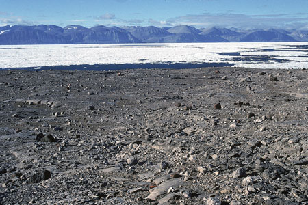
-
Article
Herschel Island
Herschel Island, 101 km 2 , lies in the Beaufort Sea off the north coast of the Yukon Territory.
"https://d2ttikhf7xbzbs.cloudfront.net/media/media/b504d03a-1419-4bf4-ab27-00b5e8cc89a0.jpg" // resources/views/front/categories/view.blade.php
https://d2ttikhf7xbzbs.cloudfront.net/media/media/b504d03a-1419-4bf4-ab27-00b5e8cc89a0.jpg
-
Article
Hornby Island
Hornby Island lies in the Strait of Georgia between Vancouver Island and mainland British Columbia, southeast of the island community of Courtenay . It is a wooded island with a shoreline of sandbanks and rock shelves.
"https://d2ttikhf7xbzbs.cloudfront.net/media/media/44ecf87e-919b-40ea-8039-8eefd6a41399.jpg" // resources/views/front/categories/view.blade.php
https://d2ttikhf7xbzbs.cloudfront.net/media/media/44ecf87e-919b-40ea-8039-8eefd6a41399.jpg
-
Article
Île-à-la-Crosse
Île-à-la-Crosse, Sask, incorporated as a northern village in 1965, population 1365 (2011c), 1341 (2006c). The Northern Village of Île-à-la-Crosse is located on an expansion of the upper Churchill River, called Lac Île-à-la-Crosse.
"https://d2ttikhf7xbzbs.cloudfront.net/media/media/ba52302c-a4c1-4e6c-86c7-3c89989b6341.jpg" // resources/views/front/categories/view.blade.php
https://d2ttikhf7xbzbs.cloudfront.net/media/media/ba52302c-a4c1-4e6c-86c7-3c89989b6341.jpg
-
Article
Île aux Coudres
Île aux Coudres, 30 km 2 , 11 km long, 4.3 km wide, 92 m high, is situated 60 km downstream from Québec City in the ST LAWRENCE RIVER estuary. The island consists of 2 Appalachian ridges joined by an embankment.
"https://d2ttikhf7xbzbs.cloudfront.net/media/media/bc348064-f5a1-419f-97b9-befa81a5bdb1.jpg" // resources/views/front/categories/view.blade.php
https://d2ttikhf7xbzbs.cloudfront.net/media/media/bc348064-f5a1-419f-97b9-befa81a5bdb1.jpg
-
Article
Île Bonaventure
Despite its minute size, a favourable climate and abundant cod stocks induced French entrepreneurs to establish a seasonal fishery operation there in the 1600s. Simon Denys obtained seigneurial title (1674); his son Pierre had a chapel erected, soon thereafter razed by fire (1690).
"https://d2ttikhf7xbzbs.cloudfront.net/media/media/b2be0d1b-9e0f-4794-997a-2ec03cbfab51.jpg" // resources/views/front/categories/view.blade.php
https://d2ttikhf7xbzbs.cloudfront.net/media/media/b2be0d1b-9e0f-4794-997a-2ec03cbfab51.jpg
-
Article
Île d’Anticosti
Île d'Anticosti, 7,943 km2, 222 km long and 56 km at its widest point, is located in the Gulf of St. Lawrence, athwart the entrance to the St. Lawrence River. Though considerably larger than Prince Edward Island, its population is only about 200. In September 2023, the island was designated a UNESCO World Heritage Site.
"https://d2ttikhf7xbzbs.cloudfront.net/iledanticosti/RiviereHuileAnticosti.jpg" // resources/views/front/categories/view.blade.php
https://d2ttikhf7xbzbs.cloudfront.net/iledanticosti/RiviereHuileAnticosti.jpg
-
Article
Île d'Orléans
The island is connected by a suspension bridge to the North Shore near CHUTE MONTMORENCY. The largest island in the river after Île de Montréal, it is a relatively level plateau, 137 m at its highest point, and is quite steep-sided.
"https://d2ttikhf7xbzbs.cloudfront.net/media/media/fed833c0-33df-4cf6-81dc-9b2390d4d1ed.jpg" // resources/views/front/categories/view.blade.php
https://d2ttikhf7xbzbs.cloudfront.net/media/media/fed833c0-33df-4cf6-81dc-9b2390d4d1ed.jpg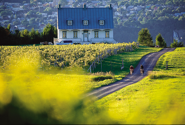
-
Article
Île de la Grande Entrée
Île de la Grande Entrée, Qué, is situated almost in the middle of the Gulf of ST LAWRENCE and flanked in the north by Île d' ANTICOSTI, in the south by PRINCE EDWARD ISLAND and on the east by CABOT STRAIT. It is one of the 16 islands and islets comprising Îles-de-la-MADELEINE.
"https://development.thecanadianencyclopedia.ca/images/tce_placeholder.jpg?v=e9dca980c9bdb3aa11e832e7ea94f5d9" // resources/views/front/categories/view.blade.php
https://development.thecanadianencyclopedia.ca/images/tce_placeholder.jpg?v=e9dca980c9bdb3aa11e832e7ea94f5d9
-
Article
Île du Bic
Bic, Île du, uninhabited island, 14 km2, is located in the ST LAWRENCE R, 30 km west of Rimouski, Qué. Because of its advantageous position at the mouth of the St Lawrence near the natural harbour of Bic, it played a key military role under the French regime.
"https://development.thecanadianencyclopedia.ca/images/tce_placeholder.jpg?v=e9dca980c9bdb3aa11e832e7ea94f5d9" // resources/views/front/categories/view.blade.php
https://development.thecanadianencyclopedia.ca/images/tce_placeholder.jpg?v=e9dca980c9bdb3aa11e832e7ea94f5d9
-
Article
Île du Cap aux Meules
Île du Cap aux Meules, Qué, 50 km2, is one island in the Îles de la MADELEINE archipelago, located in the middle of the Gulf of ST LAWRENCE. It is named after the sandstone hill that supplied the stone used to make grindstones (meules in French) for flour mills.
"https://development.thecanadianencyclopedia.ca/images/tce_placeholder.jpg?v=e9dca980c9bdb3aa11e832e7ea94f5d9" // resources/views/front/categories/view.blade.php
https://development.thecanadianencyclopedia.ca/images/tce_placeholder.jpg?v=e9dca980c9bdb3aa11e832e7ea94f5d9
-
Article
Île Lamèque
Île Lamèque, 150 km2, is located off the northeast corner of New Brunswick at the entrance to Chaleur Bay.
"https://development.thecanadianencyclopedia.ca/images/tce_placeholder.jpg?v=e9dca980c9bdb3aa11e832e7ea94f5d9" // resources/views/front/categories/view.blade.php
https://development.thecanadianencyclopedia.ca/images/tce_placeholder.jpg?v=e9dca980c9bdb3aa11e832e7ea94f5d9
-
Article
Îles de la Madeleine
Preceded by Basque fishermen, Jacques Cartier arrived at Île Brion in 1534; he named it in honour of the great French admiral. He christened the islands "Les Araynes" (arènes is a French poetry word for sand) because of the endless beaches of sand. Later French fishermen called them Îles Ramées.
"https://d2ttikhf7xbzbs.cloudfront.net/media/media/e3a0f397-8687-443d-a333-fd37c2506209.jpg" // resources/views/front/categories/view.blade.php
https://d2ttikhf7xbzbs.cloudfront.net/media/media/e3a0f397-8687-443d-a333-fd37c2506209.jpg
-
Article
Îles de Mingan
Native burial grounds indicate they were inhabited before Jacques Cartier first reported the islands in 1535. Surveys have also uncovered 16th-century Spanish coins and the remains of Basque habitations.
"https://d2ttikhf7xbzbs.cloudfront.net/media/media/233c4490-07ce-414e-b2d5-e30602befc75.jpg" // resources/views/front/categories/view.blade.php
https://d2ttikhf7xbzbs.cloudfront.net/media/media/233c4490-07ce-414e-b2d5-e30602befc75.jpg