Browse "Landforms"
-
Article
Badlands
Badlands are dramatic landforms characterized by a network of deep, narrow and winding gullies, along with occasional hoodoo rocks. Their steep, barren slopes provide striking evidence of the force of erosion by wind and water — a source of continual change in their terrain.
"https://d2ttikhf7xbzbs.cloudfront.net/media/media/251b5d36-82cc-4ec1-80e8-471cfd59098a.jpg" // resources/views/front/categories/view.blade.php
https://d2ttikhf7xbzbs.cloudfront.net/media/media/251b5d36-82cc-4ec1-80e8-471cfd59098a.jpg
-
Article
Bluefish Caves
Bluefish Caves contain the oldest undisturbed archaeological evidence in Canada.
"https://d2ttikhf7xbzbs.cloudfront.net/media/media/b91c5592-6724-4e23-8a45-aa3a4ce223f0.jpg" // resources/views/front/categories/view.blade.php
https://d2ttikhf7xbzbs.cloudfront.net/media/media/b91c5592-6724-4e23-8a45-aa3a4ce223f0.jpg
-
Article
Canadian Meteorite Craters
Canadian Meteorite Craters Canadian Meteorite Craters Canadian Meteorite Craters Name Location Diameter (km) Nouveau-Québec Québec 3 Brent Ontario 4 Manicouagan Québec 100 Clearwater Lake West Québec 32 Clearwater Lake East Québec 22 Holleford Ontario 2 Deep Bay Saskatchewan 12 Carswell Saskatchewan 37 Lac Couture Québec 8 West Hawk Lake Manitoba 3 Pilot Lake Northwest Territories 6 Nicholson Lake Northwest Territories 12 Steen River Alberta 25 Sudbury Ontario 140 Charlevoix Québec 46 Mistastin Lake Labrador 28...
"https://development.thecanadianencyclopedia.ca/images/tce_placeholder.jpg?v=e9dca980c9bdb3aa11e832e7ea94f5d9" // resources/views/front/categories/view.blade.php
https://development.thecanadianencyclopedia.ca/images/tce_placeholder.jpg?v=e9dca980c9bdb3aa11e832e7ea94f5d9
-
Article
Cap Wolstenholme
Cap Wolstenholme, 384 m high, is an imposing headland marking the western limit of Hudson Strait.
"https://development.thecanadianencyclopedia.ca/images/tce_placeholder.jpg?v=e9dca980c9bdb3aa11e832e7ea94f5d9" // resources/views/front/categories/view.blade.php
https://development.thecanadianencyclopedia.ca/images/tce_placeholder.jpg?v=e9dca980c9bdb3aa11e832e7ea94f5d9
-
Article
Cave
Origins Lava tube caves, an important minor class, are formed by channelled outflow of molten lava in congealing flows. Sea caves most commonly result from erosion by waves.
"https://d2ttikhf7xbzbs.cloudfront.net/media/media/fe40d379-ae39-4fca-8978-e0102f93eb01.jpg" // resources/views/front/categories/view.blade.php
https://d2ttikhf7xbzbs.cloudfront.net/media/media/fe40d379-ae39-4fca-8978-e0102f93eb01.jpg
-
Article
Delta (Landform)
A delta is a deposit of sediment at the mouth of a river that accumulates as the river flows into a standing body of water such as a lake or ocean. Because sediment tends to be rich in nutrients, deltas become fertile wetlands inhabited by diverse wildlife. Among the largest deltas in Canada are those of the Mackenzie and Saskatchewan rivers, as well as the Peace-Athabasca Delta (where the Peace, Athabasca and Birch rivers meet). Certain deltas offer advantageous access to natural resources and maritime transportation, but development projects are often controversial due to the ecological importance of these environments.
"https://d2ttikhf7xbzbs.cloudfront.net/media/media/293454d6-184b-47a4-b934-b91879492e33.jpg" // resources/views/front/categories/view.blade.php
https://d2ttikhf7xbzbs.cloudfront.net/media/media/293454d6-184b-47a4-b934-b91879492e33.jpg
-
Article
Escarpment
This is a steep or vertical cliff which usually extends over a considerable distance. The most common type of escarpment occurs where more resistant strata form a cap rock over easily eroded rocks. As EROSION takes place, the lower rock erodes more rapidly so that the cliff remains very steep.
"https://development.thecanadianencyclopedia.ca/images/tce_placeholder.jpg?v=e9dca980c9bdb3aa11e832e7ea94f5d9" // resources/views/front/categories/view.blade.php
https://development.thecanadianencyclopedia.ca/images/tce_placeholder.jpg?v=e9dca980c9bdb3aa11e832e7ea94f5d9
-
Article
Esker
An esker is a ridge (Gaelic eiscir, "ridge") of gravel and sand emplaced during glacial melt by the deposition of sediments from meltwater rivers flowing on the ice (channel fills) or beneath a glacier (tunnel fills).
"https://development.thecanadianencyclopedia.ca/images/tce_placeholder.jpg?v=e9dca980c9bdb3aa11e832e7ea94f5d9" // resources/views/front/categories/view.blade.php
https://development.thecanadianencyclopedia.ca/images/tce_placeholder.jpg?v=e9dca980c9bdb3aa11e832e7ea94f5d9
-
Article
Fraser River Canyon
The Fraser River Canyon was formed during the Miocene period (22.9-5.33 million years ago) when the river cut down into the uplifting southern part of the Interior Plateau of British Columbia. The canyon characteristics of this
"https://d2ttikhf7xbzbs.cloudfront.net/media/media/49e5b82d-d0a2-4ca6-aa37-99ecf1243a3d.jpg" // resources/views/front/categories/view.blade.php
https://d2ttikhf7xbzbs.cloudfront.net/media/media/49e5b82d-d0a2-4ca6-aa37-99ecf1243a3d.jpg
-
Article
Hells Gate
Hells Gate is a narrow rocky gorge of the Fraser River Canyon south of Boston Bar, British Columbia.
"https://d2ttikhf7xbzbs.cloudfront.net/media/media/3a0bfcc6-c4db-40cb-9d96-e5db248cc7e2.jpg" // resources/views/front/categories/view.blade.php
https://d2ttikhf7xbzbs.cloudfront.net/media/media/3a0bfcc6-c4db-40cb-9d96-e5db248cc7e2.jpg
-
Article
Hoodoo Rock
Hoodoo rocks are often fantastically shaped, naturally carved rocks or earth pedestals, pillars or columns. The word hoodoo probably derives from voodoo, a West African-based religion in which magical powers can be associated with natural features. Hoodoos conjure up images of strange events.
"https://d2ttikhf7xbzbs.cloudfront.net/media/media/251b5d36-82cc-4ec1-80e8-471cfd59098a.jpg" // resources/views/front/categories/view.blade.php
https://d2ttikhf7xbzbs.cloudfront.net/media/media/251b5d36-82cc-4ec1-80e8-471cfd59098a.jpg
-
Article
Meteors, Meteorites and Impact Craters
The solar system contains many objects smaller than the planets (or their satellites) travelling in individual orbits about the SUN; space between the planets also contains myriad dust grains in the micron size range. Near Earth, dust concentrations are only a few hundred particles per cubic kilometre, but 35 000 to 100 000 t of extraterrestrial material enters the atmosphere annually, swept up by our planet from debris that is in its path or crosses its path.
"https://d2ttikhf7xbzbs.cloudfront.net/media/media/66e2415e-3179-44e5-a06b-e73edf3aa050.jpg" // resources/views/front/categories/view.blade.php
https://d2ttikhf7xbzbs.cloudfront.net/media/media/66e2415e-3179-44e5-a06b-e73edf3aa050.jpg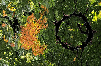
-
"https://development.thecanadianencyclopedia.ca/images/tce_placeholder.jpg?v=e9dca980c9bdb3aa11e832e7ea94f5d9" // resources/views/front/categories/view.blade.php
https://development.thecanadianencyclopedia.ca/images/tce_placeholder.jpg?v=e9dca980c9bdb3aa11e832e7ea94f5d9
-
Article
Moraine
A moraine is a landform composed of an accumulation of sediment deposited by or from a GLACIER and possessing a form independent of the terrain beneath it.
"https://development.thecanadianencyclopedia.ca/images/tce_placeholder.jpg?v=e9dca980c9bdb3aa11e832e7ea94f5d9" // resources/views/front/categories/view.blade.php
https://development.thecanadianencyclopedia.ca/images/tce_placeholder.jpg?v=e9dca980c9bdb3aa11e832e7ea94f5d9
-
Article
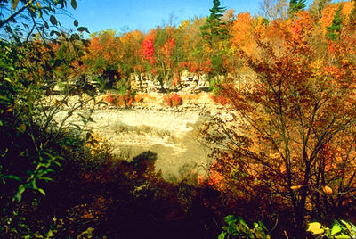
Niagara Escarpment
The Niagara Escarpment, in its Ontario portion, is 725 km long, covering 1923 km2, with a maximum height of 335 m.
"https://d2ttikhf7xbzbs.cloudfront.net/media/media/5e74cb9f-53c2-453f-8ffd-322cbcf683cb.jpg" // resources/views/front/categories/view.blade.php
https://d2ttikhf7xbzbs.cloudfront.net/media/media/5e74cb9f-53c2-453f-8ffd-322cbcf683cb.jpg