Browse "Regions"
-
Article
Beringia
The importance of Beringia is twofold: it provided a pathway for intercontinental exchanges of plants and animals during glacial periods and for interoceanic exchanges during interglacials; it has been a centre of evolution and has supported apparently unique plant and animal communities.
"https://d2ttikhf7xbzbs.cloudfront.net/media/media/b91c5592-6724-4e23-8a45-aa3a4ce223f0.jpg" // resources/views/front/categories/view.blade.php
https://d2ttikhf7xbzbs.cloudfront.net/media/media/b91c5592-6724-4e23-8a45-aa3a4ce223f0.jpg
-
Article
Cassiar District
The Cassiar District lies in British Columbia's northwest corner; it historically encompasses the Stikine and Dease River watersheds and that of the upper Taku, NASS and Kechika.
"https://development.thecanadianencyclopedia.ca/images/tce_placeholder.jpg?v=e9dca980c9bdb3aa11e832e7ea94f5d9" // resources/views/front/categories/view.blade.php
https://development.thecanadianencyclopedia.ca/images/tce_placeholder.jpg?v=e9dca980c9bdb3aa11e832e7ea94f5d9
-
"https://d2ttikhf7xbzbs.cloudfront.net/media/media/57efb97e-fd6e-4a08-85d6-ce216c441360.jpg" // resources/views/front/categories/view.blade.php
https://d2ttikhf7xbzbs.cloudfront.net/media/media/57efb97e-fd6e-4a08-85d6-ce216c441360.jpg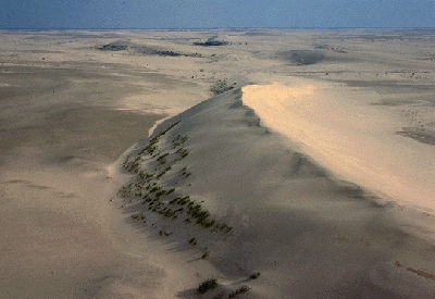
-
Article
Drainage Basin
A drainage basin is an area of land that contributes the water it receives as precipitation to a river or network of rivers.
"https://development.thecanadianencyclopedia.ca/images/tce_placeholder.jpg?v=e9dca980c9bdb3aa11e832e7ea94f5d9" // resources/views/front/categories/view.blade.php
https://development.thecanadianencyclopedia.ca/images/tce_placeholder.jpg?v=e9dca980c9bdb3aa11e832e7ea94f5d9
-
Editorial
Drought in Palliser's Triangle
The following article is an editorial written by The Canadian Encyclopedia staff. Editorials are not usually updated.
"https://development.thecanadianencyclopedia.ca/images/tce_placeholder.jpg?v=e9dca980c9bdb3aa11e832e7ea94f5d9" // resources/views/front/categories/view.blade.php
https://development.thecanadianencyclopedia.ca/images/tce_placeholder.jpg?v=e9dca980c9bdb3aa11e832e7ea94f5d9
-
Article
Eastmain
Eastmain (or East Main) refers to the east shore of Hudson Bay, although in the 1680s the term was restricted to the vicinity of the Eastmain River. The corresponding reference to the west shore of Hudson Bay is the Westmain (West Main).
"https://development.thecanadianencyclopedia.ca/images/tce_placeholder.jpg?v=e9dca980c9bdb3aa11e832e7ea94f5d9" // resources/views/front/categories/view.blade.php
https://development.thecanadianencyclopedia.ca/images/tce_placeholder.jpg?v=e9dca980c9bdb3aa11e832e7ea94f5d9
-
Article
Foothills
Foothills, a region of rolling, undulating or hilly terrain lying between an area of plains and a mountain range.
"https://d2ttikhf7xbzbs.cloudfront.net/media/media/1a15198f-4119-4d42-b163-cac45bab0ac1.jpg" // resources/views/front/categories/view.blade.php
https://d2ttikhf7xbzbs.cloudfront.net/media/media/1a15198f-4119-4d42-b163-cac45bab0ac1.jpg
-
Article
Forest
A forest is an ecosystem characterized by a dense and extensive tree cover. It includes not only trees but also shrubs, vines, herbs, mosses, microorganisms, insects, and vertebrate animals that interact with each other and with their environment. This complex pattern of life is a system in delicate balance. Natural or human-caused alterations may trigger far-reaching and sometimes disastrous changes.
"https://d2ttikhf7xbzbs.cloudfront.net/forest/Spruce-Forest-in-Winter.jpg" // resources/views/front/categories/view.blade.php
https://d2ttikhf7xbzbs.cloudfront.net/forest/Spruce-Forest-in-Winter.jpg
-
Article
Forest Regions
A forest region is a major geographic belt or zone characterized by a broad uniformity both in physiography and in the composition of the dominant tree species. Canada can be divided into eight forest regions.
"https://d2ttikhf7xbzbs.cloudfront.net/media/media/b56c04a4-f128-4027-93d9-f3a9c96c6632.jpg" // resources/views/front/categories/view.blade.php
https://d2ttikhf7xbzbs.cloudfront.net/media/media/b56c04a4-f128-4027-93d9-f3a9c96c6632.jpg
-
Article
Fraser River Lowland
The Fraser River Lowland is a triangular area in southwestern British Columbia. The eastern apex of the triangle is at Hope, about 160 km inland from the Strait of Georgia. From here, the lowland broadens to the west to a width of about 50 km. The international boundary between British Columbia and Washington State crosses the southwestern part of the lowland. The Coast Mountains form the northern boundary of the delta-lowland. The Fraser River Lowland is the largest area of level land with suitable agricultural soils in coastal British Columbia.
"https://d2ttikhf7xbzbs.cloudfront.net/media/new_article_images/FraserRiverLowland/FraserRiverLowlandMap.png" // resources/views/front/categories/view.blade.php
https://d2ttikhf7xbzbs.cloudfront.net/media/new_article_images/FraserRiverLowland/FraserRiverLowlandMap.png
-
Article
Geological Regions (Plain-Language Summary)
Geology is the study of what the Earth is made of and how it has changed over time. There are six geological regions in Canada. These regions are the Canadian Shield, the Interior Platform, the Appalachian Orogen, the Innuitian Orogen, the Cordillera and Western Canada Sedimentary Basin, and the Eastern Continental Margin. This article is a plain-language summary of the geological regions of Canada. If you are interested in reading about this topic in more depth, please see the full-length entry, Geological Regions.
"https://d2ttikhf7xbzbs.cloudfront.net/media/media/e6e2df67-a33a-46cb-ab6d-dc659323ec1d.jpg" // resources/views/front/categories/view.blade.php
https://d2ttikhf7xbzbs.cloudfront.net/media/media/e6e2df67-a33a-46cb-ab6d-dc659323ec1d.jpg
-
"https://development.thecanadianencyclopedia.ca/images/tce_placeholder.jpg?v=e9dca980c9bdb3aa11e832e7ea94f5d9" // resources/views/front/categories/view.blade.php
https://development.thecanadianencyclopedia.ca/images/tce_placeholder.jpg?v=e9dca980c9bdb3aa11e832e7ea94f5d9
-
Article
Holland Marsh
Holland Marsh, 2900 ha of organic (muck) soil, is located near Bradford West Gwillimbury, Ont, 50 km north of Toronto.
"https://d2ttikhf7xbzbs.cloudfront.net/media/media/01f0989f-5102-44b1-82b6-1b7a44b8ff1d.jpg" // resources/views/front/categories/view.blade.php
https://d2ttikhf7xbzbs.cloudfront.net/media/media/01f0989f-5102-44b1-82b6-1b7a44b8ff1d.jpg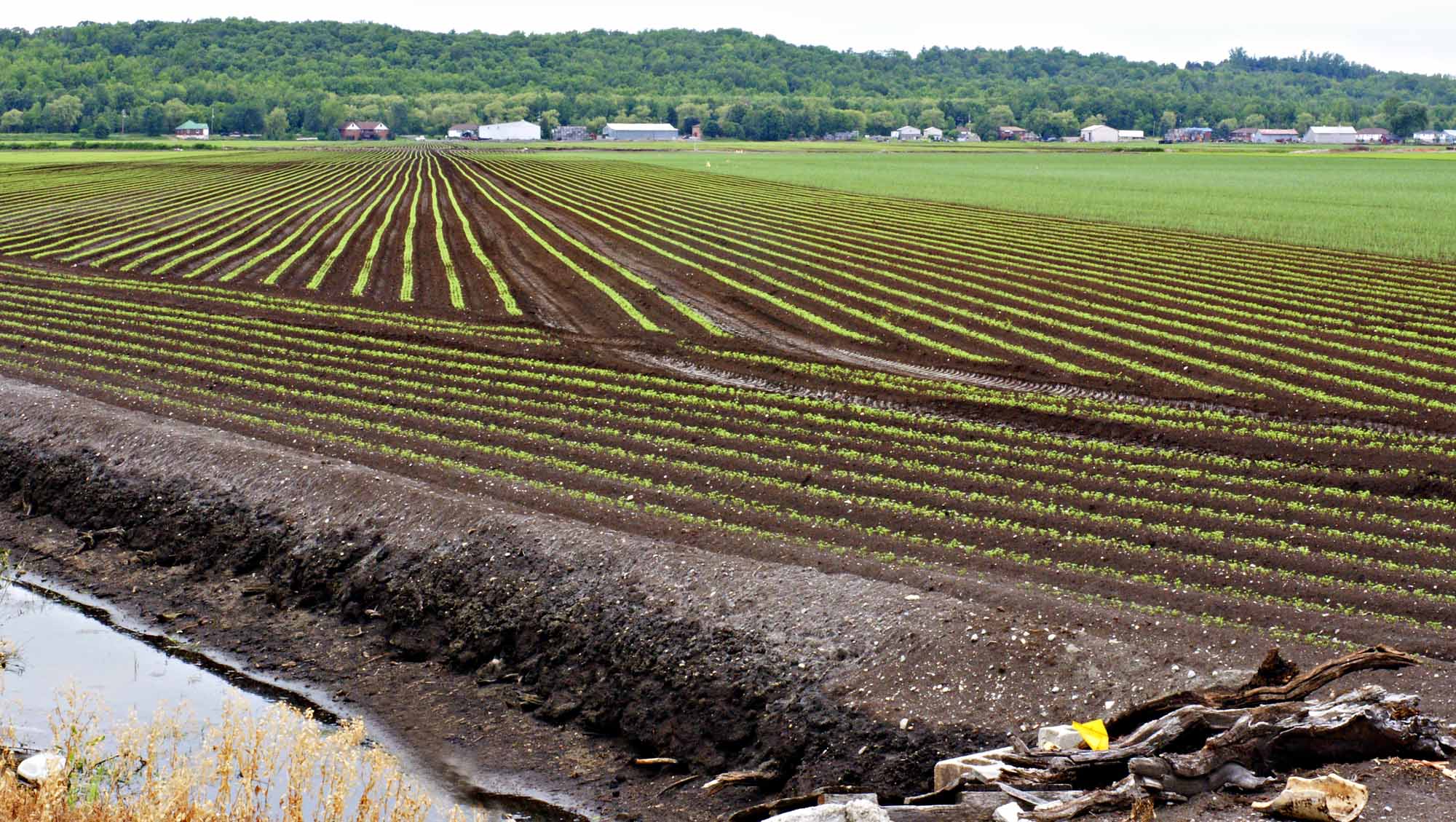
-
Article
Horton Plain
The vegetation is low arctic tundra in the N, dominated by dwarf shrubs and grasses, and woodland in the S, consisting of scattered, stunted spruce with a lichen carpet. The summer range and calving grounds of the large Bluenose caribou herd lie within this region.
"https://development.thecanadianencyclopedia.ca/images/tce_placeholder.jpg?v=e9dca980c9bdb3aa11e832e7ea94f5d9" // resources/views/front/categories/view.blade.php
https://development.thecanadianencyclopedia.ca/images/tce_placeholder.jpg?v=e9dca980c9bdb3aa11e832e7ea94f5d9
-
Article
Innuitian Region
The Innuitian Region (also known as the Innuitian Orogen) is one of Canada’s six geological regions.
"https://d2ttikhf7xbzbs.cloudfront.net/media/media/5176d9ce-bf5f-4fdf-9453-c0f71b3128e6.jpg" // resources/views/front/categories/view.blade.php
https://d2ttikhf7xbzbs.cloudfront.net/media/media/5176d9ce-bf5f-4fdf-9453-c0f71b3128e6.jpg