Browse "Geographical features"
-
Article
Quill Lakes
The Quill Lakes are three connected saline lakes in southeastern Saskatchewan. They are located 150 km north of Regina and 152 km east of Saskatoon. From west to east the lakes are named Big Quill, Middle Quill (also known as Mud Lake) and Little Quill. Despite its name, at 181 km2 Little Quill is the second largest of the three lakes. Big Quill is the largest at 307 km2. The Quill Lakes’ elevation is 516 m.
"https://development.thecanadianencyclopedia.ca/images/tce_placeholder.jpg?v=e9dca980c9bdb3aa11e832e7ea94f5d9" // resources/views/front/categories/view.blade.php
https://development.thecanadianencyclopedia.ca/images/tce_placeholder.jpg?v=e9dca980c9bdb3aa11e832e7ea94f5d9
-
Article
Rainy Lake
Rainy Lake, 932 km2 (741 km2 in Canada), elev 338 m, is located in rough woodlands astride the Ont-Minn border, 240 km W of Lk Superior. It discharges into the Rainy R, which flows W along the border to LK OF THE WOODS.
"https://development.thecanadianencyclopedia.ca/images/tce_placeholder.jpg?v=e9dca980c9bdb3aa11e832e7ea94f5d9" // resources/views/front/categories/view.blade.php
https://development.thecanadianencyclopedia.ca/images/tce_placeholder.jpg?v=e9dca980c9bdb3aa11e832e7ea94f5d9
-
Article
Random Island
Random Island, NL, 249 km2 is the second largest island off the Island of Newfoundland (FOGO ISLAND is larger at 254 km2). Random Island runs 40 km east-west and 14 km north-south, and is situated in a deep western indentation of TRINITY BAY.
"https://development.thecanadianencyclopedia.ca/images/tce_placeholder.jpg?v=e9dca980c9bdb3aa11e832e7ea94f5d9" // resources/views/front/categories/view.blade.php
https://development.thecanadianencyclopedia.ca/images/tce_placeholder.jpg?v=e9dca980c9bdb3aa11e832e7ea94f5d9
-
Article
Red Deer River
The Red Deer River (740 km, mean annual flow rate 62 m3/s), is glacier-fed by streams from Mount Drummond and Cyclone Mountain in the Rockies of Banff National Park in Alberta. It flows east then south to join the South SASKATCHEWAN RIVER just inside Saskatchewan.
"https://development.thecanadianencyclopedia.ca/images/tce_placeholder.jpg?v=e9dca980c9bdb3aa11e832e7ea94f5d9" // resources/views/front/categories/view.blade.php
https://development.thecanadianencyclopedia.ca/images/tce_placeholder.jpg?v=e9dca980c9bdb3aa11e832e7ea94f5d9
-
Article
Red Lake
Red Lake, Ontario, incorporated as a municipality in 1998, population 4,094 (2021 census), 4,107 (2016 census). The municipality of Red Lake is located in northwestern Ontario on the shore of Red Lake, 555 km northwest of Thunder Bay. The municipality is the result of the amalgamation of the former townships of Red Lake (incorporated in 1960) and Golden (established in 1985), and the unorganized territory governed by the Madsen local services board. Red Lake consists of six communities (Madsen, Red Lake, Balmertown, Cochenour, McKenzie Island and Starratt-Olsen) that sprang up around the area's gold mines.
"https://development.thecanadianencyclopedia.ca/images/tce_placeholder.jpg?v=e9dca980c9bdb3aa11e832e7ea94f5d9" // resources/views/front/categories/view.blade.php
https://development.thecanadianencyclopedia.ca/images/tce_placeholder.jpg?v=e9dca980c9bdb3aa11e832e7ea94f5d9
-
Article
Red River
The Red River (880 km long) begins at the confluence of the Bois de Sioux and Otter Tail rivers at the border between Minnesota and North Dakota. It then flows north through southern Manitoba and into Lake Winnipeg. The last 175 km of the Red River, the portion located in Manitoba, is designated as a Canadian Heritage River due to its cultural and historical value. The Red River flows through a productive agricultural region that is prone to both drought and severe flooding — the largest flood in the area in recent history, coined “the flood of the century,” occurred in 1997. The river’s basin was once the bottom of a glacial lake, Lake Agassiz, which covered the region 8,000 years ago. Currently, the Red River provides water for municipal, industrial and agricultural uses, and offers numerous summer and winter recreational opportunities, including boating, fishing (including ice fishing), camping and skating.
"https://d2ttikhf7xbzbs.cloudfront.net/media/media/c61bdc21-634f-4316-9ab1-acb89adc0cdf.jpg" // resources/views/front/categories/view.blade.php
https://d2ttikhf7xbzbs.cloudfront.net/media/media/c61bdc21-634f-4316-9ab1-acb89adc0cdf.jpg
-
Article
Reindeer Lake
Reindeer Lake, 6650 km2, elev 337 m, max length 233 km, located on the border between northeastern Saskatchewan and northwestern Manitoba, is the second-largest lake in Saskatchewan and ninth largest in Canada. It has a heavily indented shoreline and contains numerous small islands.
"https://development.thecanadianencyclopedia.ca/images/tce_placeholder.jpg?v=e9dca980c9bdb3aa11e832e7ea94f5d9" // resources/views/front/categories/view.blade.php
https://development.thecanadianencyclopedia.ca/images/tce_placeholder.jpg?v=e9dca980c9bdb3aa11e832e7ea94f5d9
-
Article
Restigouche River
Restigouche River (Ristigouche in Québec), 200 km long, rises in the highlands of northwestern New Brunswick as the Little Main Restigouche River.
"https://development.thecanadianencyclopedia.ca/images/tce_placeholder.jpg?v=e9dca980c9bdb3aa11e832e7ea94f5d9" // resources/views/front/categories/view.blade.php
https://development.thecanadianencyclopedia.ca/images/tce_placeholder.jpg?v=e9dca980c9bdb3aa11e832e7ea94f5d9
-
Article
Rideau Lakes
Rideau Lakes, 65 km2, elev 123 m, mean depth 12.3 m, is a commonly used collective name for 3 lakes: Big Rideau, Upper Rideau and Lower Rideau.
"https://d2ttikhf7xbzbs.cloudfront.net/media/media/3f6f49a4-9e6a-4764-8ac0-b535a8fed146.jpg" // resources/views/front/categories/view.blade.php
https://d2ttikhf7xbzbs.cloudfront.net/media/media/3f6f49a4-9e6a-4764-8ac0-b535a8fed146.jpg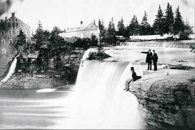
-
Article
Rideau River
The Rideau River flows 100 km northwards from the Rideau Lakes in eastern Ontario to the Ottawa River at Ottawa.
"https://d2ttikhf7xbzbs.cloudfront.net/media/media/7d8b1603-093b-431d-9c12-aa68e477912f.jpg" // resources/views/front/categories/view.blade.php
https://d2ttikhf7xbzbs.cloudfront.net/media/media/7d8b1603-093b-431d-9c12-aa68e477912f.jpg
-
"https://development.thecanadianencyclopedia.ca/images/tce_placeholder.jpg?v=e9dca980c9bdb3aa11e832e7ea94f5d9" // resources/views/front/categories/view.blade.php
https://development.thecanadianencyclopedia.ca/images/tce_placeholder.jpg?v=e9dca980c9bdb3aa11e832e7ea94f5d9
-
Article
Rivière Chaudière
Rivière Chaudière, 193 km long and with a basin 6690 km2, is located in southern Québec. It is named after the waters that "boil" from its falls or after the numerous glacial erosion kettles (chaudière is French for boiler and also for bucket).
"https://development.thecanadianencyclopedia.ca/images/tce_placeholder.jpg?v=e9dca980c9bdb3aa11e832e7ea94f5d9" // resources/views/front/categories/view.blade.php
https://development.thecanadianencyclopedia.ca/images/tce_placeholder.jpg?v=e9dca980c9bdb3aa11e832e7ea94f5d9
-
Article
Rivière de Rupert
Rivière de Rupert is 763 km long to the head of Lac Témiscamie. It drains Lac Mistassini and then follows a twisted course through a series of lakes and across a flat coastal plain to discharge into southeastern James Bay.
"https://development.thecanadianencyclopedia.ca/images/tce_placeholder.jpg?v=e9dca980c9bdb3aa11e832e7ea94f5d9" // resources/views/front/categories/view.blade.php
https://development.thecanadianencyclopedia.ca/images/tce_placeholder.jpg?v=e9dca980c9bdb3aa11e832e7ea94f5d9
-
Article
Rivière Dumoine
The Dumoine, 129 km long, rises in Lac Dumoine in southwest Québec and flows off the south edge of the Laurentian Highlands through a series of waterfalls, wild rapids and long chutes into the Ottawa River.
"https://development.thecanadianencyclopedia.ca/images/tce_placeholder.jpg?v=e9dca980c9bdb3aa11e832e7ea94f5d9" // resources/views/front/categories/view.blade.php
https://development.thecanadianencyclopedia.ca/images/tce_placeholder.jpg?v=e9dca980c9bdb3aa11e832e7ea94f5d9
-
Article
Rivière Eastmain
The Rivière Eastmain, 756 km long, rises in the central part of Québec on the side of a low drainage divide from which streams flow west to James Bay.
"https://development.thecanadianencyclopedia.ca/images/tce_placeholder.jpg?v=e9dca980c9bdb3aa11e832e7ea94f5d9" // resources/views/front/categories/view.blade.php
https://development.thecanadianencyclopedia.ca/images/tce_placeholder.jpg?v=e9dca980c9bdb3aa11e832e7ea94f5d9