Browse "Traditional Territories"
-
Article
Anthony Island
The overgrowth of lush vegetation has been cleared away from the remains of Ninstints's longhouses and totem poles, which pay silent homage to their creators.
"https://d2ttikhf7xbzbs.cloudfront.net/media/media/1c61ad08-f404-4f01-83ee-d9b43e4b833b.jpg" // resources/views/front/categories/view.blade.php
https://d2ttikhf7xbzbs.cloudfront.net/media/media/1c61ad08-f404-4f01-83ee-d9b43e4b833b.jpg
-
Article
Gwaii Haanas National Park Reserve and Haida Heritage Site
Encompassing rainforests, alpine meadows and rocky shores of southern Haida Gwaii (formerly the Queen Charlotte Islands), Gwaii Haanas National Park Reserve and Haida Heritage Site (1495 km2) harbours some species of plants and animals not found anywhere else on the globe.
"https://d2ttikhf7xbzbs.cloudfront.net/media/media/1d34f43a-14db-43e0-8206-647ca92632f2.jpg" // resources/views/front/categories/view.blade.php
https://d2ttikhf7xbzbs.cloudfront.net/media/media/1d34f43a-14db-43e0-8206-647ca92632f2.jpg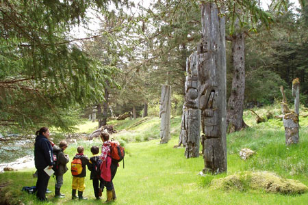
-
Article
Head-Smashed-In Buffalo Jump
Head-Smashed-In Buffalo Jump is an archaeological site located on the southern end of the Porcupine Hills in southwest Alberta.
"https://d2ttikhf7xbzbs.cloudfront.net/media/media/044efca3-4d40-4efa-b5ae-4f9f20403ea4.jpeg" // resources/views/front/categories/view.blade.php
https://d2ttikhf7xbzbs.cloudfront.net/media/media/044efca3-4d40-4efa-b5ae-4f9f20403ea4.jpeg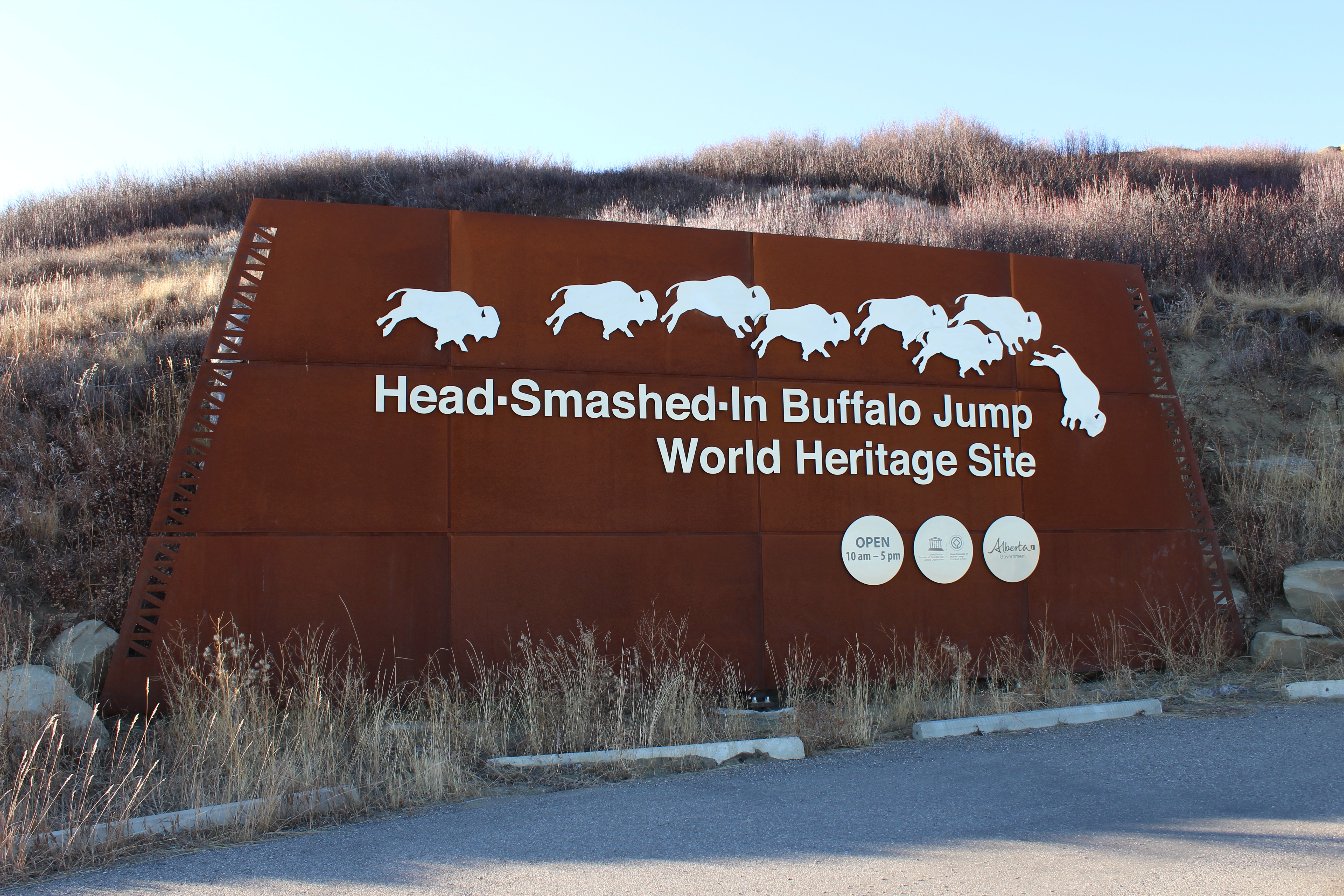
-
Article
Wendake (Huronia)
Wendake is a Huron-Wendat settlement dating back to the 17th century, once known by various names including “Huronia,” "the country of the Huron" or “the Huron village.” Today, Wendake refers to the urban reserve of the Huron-Wendat Nation, located near Quebec City, Quebec.
"https://d2ttikhf7xbzbs.cloudfront.net/media/media/dbcf9b74-90d5-42a2-8f3c-9e38996ea0b7.jpg" // resources/views/front/categories/view.blade.php
https://d2ttikhf7xbzbs.cloudfront.net/media/media/dbcf9b74-90d5-42a2-8f3c-9e38996ea0b7.jpg
-
Article
Igloolik Archaeological Sites
The Igloolik archaeological sites are located on the islands at the northern end of Foxe Basin, close to the village of Igloolik.
"https://d2ttikhf7xbzbs.cloudfront.net/media/media/737bdeaf-7011-4762-b6ab-67bc228da8ad.jpg" // resources/views/front/categories/view.blade.php
https://d2ttikhf7xbzbs.cloudfront.net/media/media/737bdeaf-7011-4762-b6ab-67bc228da8ad.jpg
-
Article
Kitigaaryuit (Kittigazuit)
Kitigaaryuit is the name of an area (ca 5 km2) at the mouth of the East Channel of the Mackenzie River that was the gathering place of the Kitigaaryungmiut.
"https://d2ttikhf7xbzbs.cloudfront.net/media/media/edd62de2-9eff-48e0-978d-f634c3dc4dc8.jpg" // resources/views/front/categories/view.blade.php
https://d2ttikhf7xbzbs.cloudfront.net/media/media/edd62de2-9eff-48e0-978d-f634c3dc4dc8.jpg
-
Article
Mica Bay Incident
In November 1849, a force of Anishinaabeg (see Ojibwe) and Métis warriors, led by Chiefs Oshawano, Shingwaukonse and Nebenaigoching, forced the Quebec and Lake Superior Mining Association to stop operating at Pointe aux Mines, Mica Bay, Lake Superior. Mica Bay is approximately 100 km northwest of Sault Ste. Marie (by road) on Lake Superior. The closure of the mine and the reaction of the Canada West authorities are known as the Mica Bay Incident.
"https://d2ttikhf7xbzbs.cloudfront.net/media/new_article_images/MicaBayIncident/Mica_Bay_c1850.jpg" // resources/views/front/categories/view.blade.php
https://d2ttikhf7xbzbs.cloudfront.net/media/new_article_images/MicaBayIncident/Mica_Bay_c1850.jpg
-
Article
Nagwichoonjik Cultural Landscape
Nagwichoonjik, meaning "river flowing through a big country," is the Gwich'in name for the Mackenzie River, the longest river in Canada and the 9th longest river in the world. The river flows through the heart of the traditional homeland of the Gwichya Gwich'in, who now largely reside in Tsiigehtchic (formerly Arctic Red River), a small community of 200 people at the confluence of the Arctic Red and Mackenzie rivers, in the northern part of the Northwest Territories. ( See also Indigenous Territory).
"https://d2ttikhf7xbzbs.cloudfront.net/media/new_article_images/Tsiigehtchic/TsiigehtchicBothRivers.jpg" // resources/views/front/categories/view.blade.php
https://d2ttikhf7xbzbs.cloudfront.net/media/new_article_images/Tsiigehtchic/TsiigehtchicBothRivers.jpg
-
Article
Rainy River Burial Mounds
The Rainy River Burial Mounds archaeological sites are located on the Canadian bank of the Rainy River in Ontario.
"https://development.thecanadianencyclopedia.ca/images/tce_placeholder.jpg?v=e9dca980c9bdb3aa11e832e7ea94f5d9" // resources/views/front/categories/view.blade.php
https://development.thecanadianencyclopedia.ca/images/tce_placeholder.jpg?v=e9dca980c9bdb3aa11e832e7ea94f5d9
-
Article
Teacher's Cove
Teacher's Cove is one of the largest of nearly 100 prehistoric sites discovered in southern New Brunswick's Passamaquoddy Bay region.
"https://development.thecanadianencyclopedia.ca/images/tce_placeholder.jpg?v=e9dca980c9bdb3aa11e832e7ea94f5d9" // resources/views/front/categories/view.blade.php
https://development.thecanadianencyclopedia.ca/images/tce_placeholder.jpg?v=e9dca980c9bdb3aa11e832e7ea94f5d9
-
Article
Toronto Feature: Teiaiagon Seneca Village
This article is from our Toronto Feature series. Features from past programs are not updated.
"https://d2ttikhf7xbzbs.cloudfront.net/media/media/acf73148-da70-4849-b57e-5d65525fa9c7.jpg" // resources/views/front/categories/view.blade.php
https://d2ttikhf7xbzbs.cloudfront.net/media/media/acf73148-da70-4849-b57e-5d65525fa9c7.jpg