Browse "Places"
-
Article
St George's
St George's, NL, incorporated as a town in 1965, population 1207 (2011c), 1246 (2006c). The Town of St George's is located on the southeast side of St George's Bay, on the west coast of Newfoundland.
"https://development.thecanadianencyclopedia.ca/images/tce_placeholder.jpg?v=e9dca980c9bdb3aa11e832e7ea94f5d9" // resources/views/front/categories/view.blade.php
https://development.thecanadianencyclopedia.ca/images/tce_placeholder.jpg?v=e9dca980c9bdb3aa11e832e7ea94f5d9
-
Article
St Hubert Mission
St Hubert MissionSt Hubert Mission, located some 16 km SW of Whitewood, Sask, originated from the settlement of a group of titled French and Belgian nobility that apparently sought to escape from adverse changes undermining their way of life in Europe and to transplant the Old World traditions of French noblesse oblige. In the mid-1880s the representative of a wealthy Frenchman bought land in the area and commenced farming operations. His home, called La Rolanderie,...
"https://development.thecanadianencyclopedia.ca/images/tce_placeholder.jpg?v=e9dca980c9bdb3aa11e832e7ea94f5d9" // resources/views/front/categories/view.blade.php
https://development.thecanadianencyclopedia.ca/images/tce_placeholder.jpg?v=e9dca980c9bdb3aa11e832e7ea94f5d9
-
Article
St. Jacobs
St. Jacobs, ON, established as a Police Village in 1904 and dissolved as such in 1972 under the Regional Municipality of Waterloo Act (1972), population 1,891 (2011c), 1,597 (2006c).
"https://d2ttikhf7xbzbs.cloudfront.net/media/media/019c8ee4-7bf6-4277-84a6-04025bd7a60e.jpg" // resources/views/front/categories/view.blade.php
https://d2ttikhf7xbzbs.cloudfront.net/media/media/019c8ee4-7bf6-4277-84a6-04025bd7a60e.jpg
-
Article
St James' Anglican Cathedral
St James' Anglican Cathedral is located at 65 Church Street (at King), Toronto, Ont. There have been four ANGLICAN churches on this site.
"https://d2ttikhf7xbzbs.cloudfront.net/media/media/d5b5d072-4525-414c-95c6-47d0cbb41b52.jpg" // resources/views/front/categories/view.blade.php
https://d2ttikhf7xbzbs.cloudfront.net/media/media/d5b5d072-4525-414c-95c6-47d0cbb41b52.jpg
-
Article
St. John's
St. John's, NL, incorporated as a city in 1921, population 110,525 (2021 census), 108,860 (2016 census). The capital and largest city of Newfoundland and Labrador, the city of St. John's is located on the eastern side of the Avalon Peninsula of southeast Newfoundland. Its landlocked harbour is approached through a long, narrow channel and is protected by the high hills on which the city is built. The origin of the name St. John's is not known, but its use appears on a Portuguese map by Pedro Reinel (1516–20) as "Rio de San Johem" and later, in a 1527 letter by the English seaman John Rut, as the "Haven of St. John's." According to popular folklore, however, the city takes its name from the feast of Saint John the Baptist and the arrival of Italian explorer Giovanni Caboto (John Cabot) on the shores of Newfoundland on 24 June 1497.
"https://d2ttikhf7xbzbs.cloudfront.net/media/media/fa98a7ea-65f5-47f6-9d63-252242142821.jpg" // resources/views/front/categories/view.blade.php
https://d2ttikhf7xbzbs.cloudfront.net/media/media/fa98a7ea-65f5-47f6-9d63-252242142821.jpg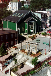
-
Article
Music in St John's
The capital city of Newfoundland and Labrador, situated on the northeastern arm of the Avalon peninsula. St John's claims to be the oldest settled and continuously occupied European community in North America.
"https://development.thecanadianencyclopedia.ca/images/tce_placeholder.jpg?v=e9dca980c9bdb3aa11e832e7ea94f5d9" // resources/views/front/categories/view.blade.php
https://development.thecanadianencyclopedia.ca/images/tce_placeholder.jpg?v=e9dca980c9bdb3aa11e832e7ea94f5d9
-
Article
St Joseph Island
St Joseph Island, 370 km2, lies at the east entrance of the ST MARYS RIVER in the North Channel connecting Lakes HURON and SUPERIOR, about 30 km southeast of Sault Ste Marie, Ont. The island is the most westerly section of the Canadian portion of the NIAGARA ESCARPMENT.
"https://development.thecanadianencyclopedia.ca/images/tce_placeholder.jpg?v=e9dca980c9bdb3aa11e832e7ea94f5d9" // resources/views/front/categories/view.blade.php
https://development.thecanadianencyclopedia.ca/images/tce_placeholder.jpg?v=e9dca980c9bdb3aa11e832e7ea94f5d9
-
Article
St Lawrence
St Lawrence, NL, incorporated as a town in 1949, population 1244 (2011c), 1349 (2006c). The Town of St Lawrence is located in the southeast corner of Newfoundland on the Burin Peninsula.
"https://d2ttikhf7xbzbs.cloudfront.net/media/media/b7a47460-85e0-4234-bcc2-659dcd61fad9.jpg" // resources/views/front/categories/view.blade.php
https://d2ttikhf7xbzbs.cloudfront.net/media/media/b7a47460-85e0-4234-bcc2-659dcd61fad9.jpg
-
Article
St Lawrence and Atlantic Railroad
St Lawrence and Atlantic Railroad, the world's first international railway, began service and was completed and inaugurated on 18 July 1853.
"https://development.thecanadianencyclopedia.ca/images/tce_placeholder.jpg?v=e9dca980c9bdb3aa11e832e7ea94f5d9" // resources/views/front/categories/view.blade.php
https://development.thecanadianencyclopedia.ca/images/tce_placeholder.jpg?v=e9dca980c9bdb3aa11e832e7ea94f5d9
-
Article
St. Lawrence Centre for the Arts
St. Lawrence Centre for the Arts. A theatre complex in Toronto, located on Front St and built as the city's centennial project.
"https://development.thecanadianencyclopedia.ca/images/tce_placeholder.jpg?v=e9dca980c9bdb3aa11e832e7ea94f5d9" // resources/views/front/categories/view.blade.php
https://development.thecanadianencyclopedia.ca/images/tce_placeholder.jpg?v=e9dca980c9bdb3aa11e832e7ea94f5d9
-
Article
St. Lawrence Hall
St. Lawrence Hall opened in 1850 and was Toronto’s first large meeting hall. Named for Canada's patron saint, it was for many years the centre of cultural and political life in Toronto, hosting many balls, receptions, concerts, exhibitions and lectures.
"https://d2ttikhf7xbzbs.cloudfront.net/media/media/4a2002b5-4f06-4779-b81c-f1dab18f90af.jpg" // resources/views/front/categories/view.blade.php
https://d2ttikhf7xbzbs.cloudfront.net/media/media/4a2002b5-4f06-4779-b81c-f1dab18f90af.jpg
-
Article
St Lawrence Hall
In 1967, as a Toronto centennial project, the building was restored, and the auditorium came into use again for social functions and chamber music concerts.The building also houses the administrative offices and rehearsal rooms of the National Ballet of Canada.
"https://d2ttikhf7xbzbs.cloudfront.net/media/media/4a2002b5-4f06-4779-b81c-f1dab18f90af.jpg" // resources/views/front/categories/view.blade.php
https://d2ttikhf7xbzbs.cloudfront.net/media/media/4a2002b5-4f06-4779-b81c-f1dab18f90af.jpg
-
Article
Thousand Islands National Park (formerly St Lawrence Islands National Park)
Most of the park islands are the summits of ancient hills of the Frontenac Axis, a strip of Precambrian granite connecting the Canadian Shield with the Adirondack Mountains in New York State.
"https://d2ttikhf7xbzbs.cloudfront.net/media/media/fad571a1-9624-4927-9403-e3b2560a4951.jpg" // resources/views/front/categories/view.blade.php
https://d2ttikhf7xbzbs.cloudfront.net/media/media/fad571a1-9624-4927-9403-e3b2560a4951.jpg
-
Article
St. Lawrence Lowland
St. Lawrence Lowland is a plain along the St. Lawrence River between Québec City in the east and Brockville, Ontario, in the west, including the Ottawa River valley west to Renfrew, Ontario.
"https://development.thecanadianencyclopedia.ca/images/tce_placeholder.jpg?v=e9dca980c9bdb3aa11e832e7ea94f5d9" // resources/views/front/categories/view.blade.php
https://development.thecanadianencyclopedia.ca/images/tce_placeholder.jpg?v=e9dca980c9bdb3aa11e832e7ea94f5d9
-
Article
St. Lawrence River
The St. Lawrence River is a grand river and estuary, which together with the Great Lakes forms a hydrographic system that penetrates 3,058 km into North America. The river proper, about 1,197 km long, issues from Lake Ontario, flows northeast past Montreal and Quebec City to the Gulf of St. Lawrence. The route of early explorers and the main axis of New France, the St. Lawrence River figured prominently in Canada's early history, and it remains the focus of settlement for much of the province of Quebec. It is still the most important commercial waterway in Canada, as well as a source of electric power and natural beauty. (See also St Lawrence Lowland.)
"https://d2ttikhf7xbzbs.cloudfront.net/media/media/1eeb7988-0d07-4c68-94e3-1f814becb0f5.jpg" // resources/views/front/categories/view.blade.php
https://d2ttikhf7xbzbs.cloudfront.net/media/media/1eeb7988-0d07-4c68-94e3-1f814becb0f5.jpg