Browse "Places"
-
Article
City Parks
The period of intense park building (1880-1914) was stimulated by an interplay of 4 factors. The first was a belief that the city dweller's increasing separation from nature caused physical, mental and moral distress. Parks were seen as healing antidotes to this urban malaise.
"https://d2ttikhf7xbzbs.cloudfront.net/media/media/bcb1b4bb-e360-49d1-832f-a77992190b08.jpg" // resources/views/front/categories/view.blade.php
https://d2ttikhf7xbzbs.cloudfront.net/media/media/bcb1b4bb-e360-49d1-832f-a77992190b08.jpg
-
Article
Clarence-Rockland
Clarence-Rockland, Ont, incorporated as a city in 1998, population 23 185 (2011c), 20 790 (2006c). The City of Clarence-Rockland is located on the OTTAWA RIVER 35 km east of OTTAWA.
"https://d2ttikhf7xbzbs.cloudfront.net/media/media/defe46c4-cbee-4bfe-9a93-0468c4d06603.jpg" // resources/views/front/categories/view.blade.php
https://d2ttikhf7xbzbs.cloudfront.net/media/media/defe46c4-cbee-4bfe-9a93-0468c4d06603.jpg
-
Article
Clarenville
Clarenville, NL, incorporated as a town in 1951, population 6036 (2011c), 5274 (2006c). The Town of Clarenville is situated in a long, picturesque arm facing RANDOM ISLAND on the west side of TRINITY BAY.
"https://development.thecanadianencyclopedia.ca/images/tce_placeholder.jpg?v=e9dca980c9bdb3aa11e832e7ea94f5d9" // resources/views/front/categories/view.blade.php
https://development.thecanadianencyclopedia.ca/images/tce_placeholder.jpg?v=e9dca980c9bdb3aa11e832e7ea94f5d9
-
Article
Claresholm
Claresholm, Alberta, incorporated as a town in 1905, population 3,780 (2016 census), 3,758 (2011 census). The town of Claresholm is located approximately 65 km northwest of Lethbridge. The name of the town was chosen by John Niblick, a superintendent of the Canadian Pacific Railway, in honour of his wife.
"https://d2ttikhf7xbzbs.cloudfront.net/media/media/9894a112-1445-494a-867a-8fd029020e2a.jpg" // resources/views/front/categories/view.blade.php
https://d2ttikhf7xbzbs.cloudfront.net/media/media/9894a112-1445-494a-867a-8fd029020e2a.jpg
-
Article
Clarington
Clarington, Ontario, incorporated as a municipality in 1974, population 84 548 (2011c), 77 820 (2006c). The Municipality of Clarington is located on the north shore of Lake Ontario 80 km east of Toronto within the Regional Municipality of Durham.
"https://development.thecanadianencyclopedia.ca/images/tce_placeholder.jpg?v=e9dca980c9bdb3aa11e832e7ea94f5d9" // resources/views/front/categories/view.blade.php
https://development.thecanadianencyclopedia.ca/images/tce_placeholder.jpg?v=e9dca980c9bdb3aa11e832e7ea94f5d9
-
Article
Clark's Harbour
Clark's Harbour, NS, incorporated as a town in 1919, population 820 (2011c), 860 (2006c). The Town of Clark's Harbour is situated on Cape Sable Island in Shelburne County, about 95 km southeast of Yarmouth.
"https://development.thecanadianencyclopedia.ca/images/tce_placeholder.jpg?v=e9dca980c9bdb3aa11e832e7ea94f5d9" // resources/views/front/categories/view.blade.php
https://development.thecanadianencyclopedia.ca/images/tce_placeholder.jpg?v=e9dca980c9bdb3aa11e832e7ea94f5d9
-
Article
Clayoquot Sound
Clayoquot Sound is a dramatically varied inlet of the Pacific Ocean nearly 100 km wide on the west coast of Vancouver Island (estimated area, water 784.25 km2; land including freshwater 2715.75 km2 ). Clayoquot ("clah quat") Sound takes in the highly scenic islands and mainland drainages from Quisitis Point northwest to Escalante Point. Population is concentrated at Tofino, a fishing, tourism and wilderness recreation centre at the terminus of Highway 4. Most Indigenous communities are accessible only by air or water.
"https://d2ttikhf7xbzbs.cloudfront.net/media/media/90cececc-c640-4ea8-bfdc-87f67c45f230.jpg" // resources/views/front/categories/view.blade.php
https://d2ttikhf7xbzbs.cloudfront.net/media/media/90cececc-c640-4ea8-bfdc-87f67c45f230.jpg
-
Article
Clearwater River
Clearwater River, 280 km long, rises in Patterson, Forest and Lloyd lakes in northwest Saskatchewan, flows southeast to Careen Lake and abruptly turns west to join the ATHABASCA RIVER at Fort McMurray, Alberta.
"https://development.thecanadianencyclopedia.ca/images/tce_placeholder.jpg?v=e9dca980c9bdb3aa11e832e7ea94f5d9" // resources/views/front/categories/view.blade.php
https://development.thecanadianencyclopedia.ca/images/tce_placeholder.jpg?v=e9dca980c9bdb3aa11e832e7ea94f5d9
-
Article
Clement Ligoure
Clement Courtenay Ligoure, physician (born 13 October 1887 in Trinidad; died 23 May 1922 Port of Spain, Trinidad). Dr. Ligoure was Halifax’s first Black doctor and an unsung hero of the Halifax Explosion, as he treated hundreds of patients free of charge in his home medical office. Dr. Ligoure was also instrumental in the formation of the No. 2 Construction Battalion, Canada’s first and only all-Black battalion (see Black Canadians; Caribbean Canadians).
"https://d2ttikhf7xbzbs.cloudfront.net/clementligoure/clementcourtenayligoure.jpg" // resources/views/front/categories/view.blade.php
https://d2ttikhf7xbzbs.cloudfront.net/clementligoure/clementcourtenayligoure.jpg
-
Article
Cluny Archaeological Site
The Cluny archaeological site is located along the north bank of the Bow River in south-central Alberta.
"https://d2ttikhf7xbzbs.cloudfront.net/media/media/3e3e67a5-aeaa-4856-ac64-d305e5d4be67.jpg" // resources/views/front/categories/view.blade.php
https://d2ttikhf7xbzbs.cloudfront.net/media/media/3e3e67a5-aeaa-4856-ac64-d305e5d4be67.jpg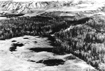
-
Article
Clyde River
Clyde River, Nunavut, incorporated as a hamlet in 1978, population 1,181 (2021 census), 1,053 (2016 census). The Hamlet of Clyde River is located on the west shore of Patricia Bay on the east coast of Baffin Island, 750 km north of Iqaluit. The Inuit name for the community, Kangirqtugaapik, means "a beautiful small cove (or bay)."
"https://d2ttikhf7xbzbs.cloudfront.net/media/media/9974cb6b-fdb8-4408-a0cb-ddcadd23aa9d.jpg" // resources/views/front/categories/view.blade.php
https://d2ttikhf7xbzbs.cloudfront.net/media/media/9974cb6b-fdb8-4408-a0cb-ddcadd23aa9d.jpg
-
Article
CN Tower
The CN Tower, Toronto, was the world's tallest free-standing structure until 2007, when the Burj Khalifa in Dubai, United Arab Emirates, surpassed it.
"https://d2ttikhf7xbzbs.cloudfront.net/media/media/59fe8f1d-94ba-48ec-a0f9-62f9e97653e4.jpg" // resources/views/front/categories/view.blade.php
https://d2ttikhf7xbzbs.cloudfront.net/media/media/59fe8f1d-94ba-48ec-a0f9-62f9e97653e4.jpg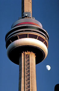
-
Article
Coaldale
Coaldale, Alberta, incorporated as a town in 1952, population 8,215 (2016 census), 7,493 (2011 census). The town of Coaldale is located in southern Alberta, just east of Lethbridge.
"https://development.thecanadianencyclopedia.ca/images/tce_placeholder.jpg?v=e9dca980c9bdb3aa11e832e7ea94f5d9" // resources/views/front/categories/view.blade.php
https://development.thecanadianencyclopedia.ca/images/tce_placeholder.jpg?v=e9dca980c9bdb3aa11e832e7ea94f5d9
-
Article
Coast
Canada's mainland coast, including the islands of Newfoundland, Cape Breton and Prince Edward Island, is 71 261 km long and fronts on the North Pacific, Arctic and North Atlantic oceans. If all measurable islands are included, the saltwater coastline has been measured at 243 797 km long. There is an additional 3800 km of freshwater coastline along the Great Lakes. Off Canada's coastline are its coastal waters extending seaward for 370 km.
"https://development.thecanadianencyclopedia.ca/images/tce_placeholder.jpg?v=e9dca980c9bdb3aa11e832e7ea94f5d9" // resources/views/front/categories/view.blade.php
https://development.thecanadianencyclopedia.ca/images/tce_placeholder.jpg?v=e9dca980c9bdb3aa11e832e7ea94f5d9
-
Article
Coast Mountains
The Coast Mountains are a continuous mountain chain extending from the Fraser Lowlands near Vancouver, 1,600 km north into the Yukon.
"https://development.thecanadianencyclopedia.ca/images/tce_placeholder.jpg?v=e9dca980c9bdb3aa11e832e7ea94f5d9" // resources/views/front/categories/view.blade.php
https://development.thecanadianencyclopedia.ca/images/tce_placeholder.jpg?v=e9dca980c9bdb3aa11e832e7ea94f5d9