Browse "Places"
-
Article
Contrecoeur
Contrecoeur was one of the first French establishments in North America. It was founded as the seigneurie de Contrecoeur in 1667 by Sieur Antoine Pécaudy de Contrecoeur, captain of the Carignan-Salières regiment. Antoine Pécaudy de Contrecoeur was born in 1596, at Vignieu en Dauphiné, France.
"https://d2ttikhf7xbzbs.cloudfront.net/media/media/d23eab8c-4936-4d32-86d2-e499a33db129.jpg" // resources/views/front/categories/view.blade.php
https://d2ttikhf7xbzbs.cloudfront.net/media/media/d23eab8c-4936-4d32-86d2-e499a33db129.jpg
-
Article
Coote Cove Archaeological Site
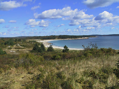
Coote Cove was once a small but vibrant 19th-century fishing community located on a large headland approximately 35 km from Halifax in Nova Scotia.
"https://d2ttikhf7xbzbs.cloudfront.net/media/media/35433013-7da6-4ad1-9adf-22da509b0c81.jpg" // resources/views/front/categories/view.blade.php
https://d2ttikhf7xbzbs.cloudfront.net/media/media/35433013-7da6-4ad1-9adf-22da509b0c81.jpg
-
Article
Coppermine River
The Coppermine River, 845 km long, rises in the Barren Lands of the Northwest Territories in Lac de Gras and flows northwest through Point Lake to Coronation Gulf on the Arctic Ocean. The majority of its course lies in Nunavut.
"https://development.thecanadianencyclopedia.ca/images/tce_placeholder.jpg?v=e9dca980c9bdb3aa11e832e7ea94f5d9" // resources/views/front/categories/view.blade.php
https://development.thecanadianencyclopedia.ca/images/tce_placeholder.jpg?v=e9dca980c9bdb3aa11e832e7ea94f5d9
-
Article
Coquihalla Highway
The Coquihalla follows the old cattle trails in BC (Corel Professional Photos). Coquihalla Highway is the largest of 4 routes connecting the Vancouver area with interior centres. Built to enhance regional tourism and to lighten traffic on the busy trucking routes, the 303 km, 4-lane highway has 3 segments. The 115 km section between Hope and Merritt follows earlier cattle trails (1876), the Kettle Valley Railway (1913-59) and oil and gas industry pipelines (begun 1958)...
"https://development.thecanadianencyclopedia.ca/images/tce_placeholder.jpg?v=e9dca980c9bdb3aa11e832e7ea94f5d9" // resources/views/front/categories/view.blade.php
https://development.thecanadianencyclopedia.ca/images/tce_placeholder.jpg?v=e9dca980c9bdb3aa11e832e7ea94f5d9
-
Article
Coquitlam
Coquitlam, British Columbia, incorporated as a city in 1992, population 148,625 (2021 census), 139,284 (2016 census). The city of Coquitlam is located on the north bank of the Fraser River between Burnaby and New Westminster to the west and Port Coquitlam and Pitt Meadows to the east. Northwest and northeast Coquitlam include the lower slopes of the Eagle and Burke Mountains, with peaks up to 1,600 m high.
"https://d2ttikhf7xbzbs.cloudfront.net/media/media/a758c067-dbf4-4c5a-82b3-fe11995f583c.jpg" // resources/views/front/categories/view.blade.php
https://d2ttikhf7xbzbs.cloudfront.net/media/media/a758c067-dbf4-4c5a-82b3-fe11995f583c.jpg
-
Article
Coral Harbour
Coral Harbour, Nunavut, incorporated as a hamlet in 1972, population 891 (2016 census), 834 (2011 census). The hamlet of Coral Harbour is located at the head of South Bay on Southampton Island in Hudson Bay, 715 km southeast of Iqaluit. The name Coral Harbour is descriptive and refers to the fossilized coral in its harbour. The Inuit’s traditional name for the site and the island, Salliq, is also descriptive and means “flat island.”
"https://development.thecanadianencyclopedia.ca/images/tce_placeholder.jpg?v=e9dca980c9bdb3aa11e832e7ea94f5d9" // resources/views/front/categories/view.blade.php
https://development.thecanadianencyclopedia.ca/images/tce_placeholder.jpg?v=e9dca980c9bdb3aa11e832e7ea94f5d9
-
Article
Cordillera
A cordillera is a major system of often parallel mountain ranges that includes the intervening plateaus, valleys and plains.
"https://d2ttikhf7xbzbs.cloudfront.net/media/media/73ca5a34-f186-4dc9-9087-6ab868db9f33.jpg" // resources/views/front/categories/view.blade.php
https://d2ttikhf7xbzbs.cloudfront.net/media/media/73ca5a34-f186-4dc9-9087-6ab868db9f33.jpg
-
Article
Cormorant Island
Cormorant Island is a small, wooded island fringed with rock beaches close to the northeast coast of Vancouver Island. ALERT BAY, a fishing port and commercial centre for nearby logging communities, is located on its south shore. The island boasts some of the finest TOTEM POLES on the BC coast.
"https://development.thecanadianencyclopedia.ca/images/tce_placeholder.jpg?v=e9dca980c9bdb3aa11e832e7ea94f5d9" // resources/views/front/categories/view.blade.php
https://development.thecanadianencyclopedia.ca/images/tce_placeholder.jpg?v=e9dca980c9bdb3aa11e832e7ea94f5d9
-
Article
Corner Brook
Corner Brook, NL, incorporated as a city in 1956, population 19 886 (2011c), 20 083 (2006c). The City of Corner Brook is located on Humber Arm of the Bay of Islands on Newfoundland's western coast.
"https://development.thecanadianencyclopedia.ca/images/tce_placeholder.jpg?v=e9dca980c9bdb3aa11e832e7ea94f5d9" // resources/views/front/categories/view.blade.php
https://development.thecanadianencyclopedia.ca/images/tce_placeholder.jpg?v=e9dca980c9bdb3aa11e832e7ea94f5d9
-
Article
Music in Corner Brook
Situated on Newfoundland's west coast, Corner Brook - the centre for business, government, transportation, and education for western Newfoundland and Labrador - is 681 km by road from the capital city, St John's.
"https://development.thecanadianencyclopedia.ca/images/tce_placeholder.jpg?v=e9dca980c9bdb3aa11e832e7ea94f5d9" // resources/views/front/categories/view.blade.php
https://development.thecanadianencyclopedia.ca/images/tce_placeholder.jpg?v=e9dca980c9bdb3aa11e832e7ea94f5d9
-
Article
Cornwall Island
Cornwall Island, 2258 km2, located in the northern ARCTIC ARCHIPELAGO, some 100 km W of Ellesmere I. It is generally low, rising to a 375 m summit towards the W. The island was discovered in 1852 by Sir Edward BELCHER and named North Cornwall.
"https://development.thecanadianencyclopedia.ca/images/tce_placeholder.jpg?v=e9dca980c9bdb3aa11e832e7ea94f5d9" // resources/views/front/categories/view.blade.php
https://development.thecanadianencyclopedia.ca/images/tce_placeholder.jpg?v=e9dca980c9bdb3aa11e832e7ea94f5d9
-
Article
Cornwall (Ontario)
Cornwall, Ontario, incorporated as a city in 1945, population 46,589 (2016 census), 46,340 (2011 census). The city of Cornwall, seat of the counties of Stormont, Dundas and Glengarry, is located on the St Lawrence River, 110 km southwest of Montreal.
"https://development.thecanadianencyclopedia.ca/images/tce_placeholder.jpg?v=e9dca980c9bdb3aa11e832e7ea94f5d9" // resources/views/front/categories/view.blade.php
https://development.thecanadianencyclopedia.ca/images/tce_placeholder.jpg?v=e9dca980c9bdb3aa11e832e7ea94f5d9
-
Article
Cornwall (PEI)
Cornwall, PEI, incorporated as a town in 1995, population 5162 (2011c), 4677 (2006c). The Town of Cornwall is located 6 kilometres west of CHARLOTTETOWN. Named after the Duchy of Cornwall in England, the community was originally
"https://d2ttikhf7xbzbs.cloudfront.net/media/media/ed92711b-394a-444d-99fe-91c3b4004888.jpg" // resources/views/front/categories/view.blade.php
https://d2ttikhf7xbzbs.cloudfront.net/media/media/ed92711b-394a-444d-99fe-91c3b4004888.jpg
-
Article
Cornwallis Island
Cornwallis Island, Nunavut, 6995 km2, is located between Bathurst Island and Devon Island in the Arctic Archipelago. It is separated from Somerset Island to the south by Barrow Strait. The island is generally flat, though there are prominent (400 m) cliffs along the east coast.
"https://d2ttikhf7xbzbs.cloudfront.net/media/media/4aad02e3-72bd-400c-87ab-d1380ccad4dc.jpg" // resources/views/front/categories/view.blade.php
https://d2ttikhf7xbzbs.cloudfront.net/media/media/4aad02e3-72bd-400c-87ab-d1380ccad4dc.jpg
-
Article
Coronach
Coronach, Sask, incorporated as a town in 1978, population 711 (2011c), 770 (2006c). The Town of Coronach is located 15 km north of the international boundary and 145 kilometres southwest of REGINA.
"https://development.thecanadianencyclopedia.ca/images/tce_placeholder.jpg?v=e9dca980c9bdb3aa11e832e7ea94f5d9" // resources/views/front/categories/view.blade.php
https://development.thecanadianencyclopedia.ca/images/tce_placeholder.jpg?v=e9dca980c9bdb3aa11e832e7ea94f5d9
