Browse "Places"
-
Article
Delta (Landform)
A delta is a deposit of sediment at the mouth of a river that accumulates as the river flows into a standing body of water such as a lake or ocean. Because sediment tends to be rich in nutrients, deltas become fertile wetlands inhabited by diverse wildlife. Among the largest deltas in Canada are those of the Mackenzie and Saskatchewan rivers, as well as the Peace-Athabasca Delta (where the Peace, Athabasca and Birch rivers meet). Certain deltas offer advantageous access to natural resources and maritime transportation, but development projects are often controversial due to the ecological importance of these environments.
"https://d2ttikhf7xbzbs.cloudfront.net/media/media/293454d6-184b-47a4-b934-b91879492e33.jpg" // resources/views/front/categories/view.blade.php
https://d2ttikhf7xbzbs.cloudfront.net/media/media/293454d6-184b-47a4-b934-b91879492e33.jpg
-
Article
Dempster Highway
The Dempster Highway runs from near Dawson, YT, 730 km across the northern Yukon through the Richardson Mountains to Fort McPherson and Inuvik, in the Mackenzie Delta of the Northwest Territories. Begun in 1959, it was the
"https://development.thecanadianencyclopedia.ca/images/tce_placeholder.jpg?v=e9dca980c9bdb3aa11e832e7ea94f5d9" // resources/views/front/categories/view.blade.php
https://development.thecanadianencyclopedia.ca/images/tce_placeholder.jpg?v=e9dca980c9bdb3aa11e832e7ea94f5d9
-
"https://d2ttikhf7xbzbs.cloudfront.net/media/media/57efb97e-fd6e-4a08-85d6-ce216c441360.jpg" // resources/views/front/categories/view.blade.php
https://d2ttikhf7xbzbs.cloudfront.net/media/media/57efb97e-fd6e-4a08-85d6-ce216c441360.jpg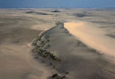
-
Article
Destruction Bay
Destruction Bay, Yukon, Settlement, population 35 (2011c), 55 (2006c). Destruction Bay is located on the west side of Kluane Lake between HAINES JUNCTION and BURWASH LANDING at Mile 1083 on the Alaska Highway.
"https://development.thecanadianencyclopedia.ca/images/tce_placeholder.jpg?v=e9dca980c9bdb3aa11e832e7ea94f5d9" // resources/views/front/categories/view.blade.php
https://development.thecanadianencyclopedia.ca/images/tce_placeholder.jpg?v=e9dca980c9bdb3aa11e832e7ea94f5d9
-
Article
Detroit River
The Detroit River, 52 km long, flows south from Lake ST CLAIR to the west end of Lake ERIE, forming part of the boundary between Ontario and Michigan. Detroit, Michigan, and WINDSOR, Ontario, dominate its shores. Part of the ST LAWRENCE SEAWAY, it is heavily used by commercial traffic.
"https://development.thecanadianencyclopedia.ca/images/tce_placeholder.jpg?v=e9dca980c9bdb3aa11e832e7ea94f5d9" // resources/views/front/categories/view.blade.php
https://development.thecanadianencyclopedia.ca/images/tce_placeholder.jpg?v=e9dca980c9bdb3aa11e832e7ea94f5d9
-
Article
Deux-Montagnes
The area was first developed for summer cottages. Later, its proximity to Montréal turned this locality into a residential suburb. Tourism and agriculture, once the mainstays of the local economy, have almost disappeared.
"https://development.thecanadianencyclopedia.ca/images/tce_placeholder.jpg?v=e9dca980c9bdb3aa11e832e7ea94f5d9" // resources/views/front/categories/view.blade.php
https://development.thecanadianencyclopedia.ca/images/tce_placeholder.jpg?v=e9dca980c9bdb3aa11e832e7ea94f5d9
-
Article
Devon
Devon, Alta, incorporated as a village in 1949 and as a town in 1950, population 6510 (2011c), 6256 (2006c). The Town of Devon is located about 30 km southwest of Edmonton, high on the banks of the North Saskatchewan River.
"https://development.thecanadianencyclopedia.ca/images/tce_placeholder.jpg?v=e9dca980c9bdb3aa11e832e7ea94f5d9" // resources/views/front/categories/view.blade.php
https://development.thecanadianencyclopedia.ca/images/tce_placeholder.jpg?v=e9dca980c9bdb3aa11e832e7ea94f5d9
-
Article
Devon Island
The Truelove Lowland area of the island has diverse vegetation and wildlife, an abundance of soil water in the summer owing to blocked drainage, and greater precipitation and higher summer temperatures (4° to 8°C), with more clear days than other parts of the island.
"https://d2ttikhf7xbzbs.cloudfront.net/media/media/4aad02e3-72bd-400c-87ab-d1380ccad4dc.jpg" // resources/views/front/categories/view.blade.php
https://d2ttikhf7xbzbs.cloudfront.net/media/media/4aad02e3-72bd-400c-87ab-d1380ccad4dc.jpg
-
Article
Devon Island Miocene Fossils
FOSSIL bones were first discovered in 1978 in the rocks formed in the now vanished Haughton Lake.
"https://development.thecanadianencyclopedia.ca/images/tce_placeholder.jpg?v=e9dca980c9bdb3aa11e832e7ea94f5d9" // resources/views/front/categories/view.blade.php
https://development.thecanadianencyclopedia.ca/images/tce_placeholder.jpg?v=e9dca980c9bdb3aa11e832e7ea94f5d9
-
Article
Dewdney Trail
The original Dewdney Trail was a 400 km trail route extending from Hope to Galbraith's Ferry on the Kootenay River. The trail was routed and constructed under the supervision of Edgar DEWDNEY, a civil engineer appointed by Frederick Seymour, the governor of the colony of BC, in April 1865.
"https://development.thecanadianencyclopedia.ca/images/tce_placeholder.jpg?v=e9dca980c9bdb3aa11e832e7ea94f5d9" // resources/views/front/categories/view.blade.php
https://development.thecanadianencyclopedia.ca/images/tce_placeholder.jpg?v=e9dca980c9bdb3aa11e832e7ea94f5d9
-
Article
Didsbury
Didsbury, Alta, incorporated as a town in 1906, population 4957 (2011c), 4305 (2006c). The Town of Didsbury is located about 75 km north of Calgary and is named after the town of Didsbury near Manchester in England.
"https://development.thecanadianencyclopedia.ca/images/tce_placeholder.jpg?v=e9dca980c9bdb3aa11e832e7ea94f5d9" // resources/views/front/categories/view.blade.php
https://development.thecanadianencyclopedia.ca/images/tce_placeholder.jpg?v=e9dca980c9bdb3aa11e832e7ea94f5d9
-
Article
Diefenbunker, Canada's Cold War Museum
The "Diefenbunker" is an underground bunker designed to withstand the force of a nuclear blast. It was built in Carp, Ontario, during a peak in Cold War tensions between 1959 and 1961, and named after then-Prime Minister John Diefenbaker. It is now the location of Canada’s Cold War Museum.
"https://d2ttikhf7xbzbs.cloudfront.net/media/new_article_images/Diefenbunker_Tunnel.jpg" // resources/views/front/categories/view.blade.php
https://d2ttikhf7xbzbs.cloudfront.net/media/new_article_images/Diefenbunker_Tunnel.jpg
-
Article
Dieppe Raid
During the Second World War, on 19 August 1942, the Allies launched a major raid on the French coastal port of Dieppe. Operation Jubilee was the first Canadian Army engagement in the European theatre of the war, designed to test the Allies' ability to launch amphibious assaults against Adolf Hitler's "Fortress Europe." The raid was a disaster: More than 900 Canadian soldiers were killed, and thousands more were wounded and taken prisoner. Despite the bloodshed, the raid provided valuable lessons for subsequent Allied amphibious assaults on Africa, Italy and Normandy.
"https://d2ttikhf7xbzbs.cloudfront.net/media/media/98ce9487-a6b5-44be-bd1e-a65711432b95.jpg" // resources/views/front/categories/view.blade.php
https://d2ttikhf7xbzbs.cloudfront.net/media/media/98ce9487-a6b5-44be-bd1e-a65711432b95.jpg
-
Article
Digby
Digby, NS, incorporated as a town in 1890, population 2152 (2011c), 2092 (2006c). The Town of Digby is located on the west side of the Annapolis Basin in western Nova Scotia.
"https://development.thecanadianencyclopedia.ca/images/tce_placeholder.jpg?v=e9dca980c9bdb3aa11e832e7ea94f5d9" // resources/views/front/categories/view.blade.php
https://development.thecanadianencyclopedia.ca/images/tce_placeholder.jpg?v=e9dca980c9bdb3aa11e832e7ea94f5d9
-
Article
Diggity Archaeological Site
The Diggity archaeological site is located at the southeastern end of Spednic Lake, near the entrance to Palfrey Lake, in southwestern New Brunswick.
"https://d2ttikhf7xbzbs.cloudfront.net/media/media/5c63f682-2f7c-40a8-b0d4-287fd7865464.jpg" // resources/views/front/categories/view.blade.php
https://d2ttikhf7xbzbs.cloudfront.net/media/media/5c63f682-2f7c-40a8-b0d4-287fd7865464.jpg