Browse "Places"
-
Article
Droulers-Tsiionhiakwatha Archaeological Site
The Droulers-Tsiionhiakwatha archaeological site is located in extreme southwest Québec, in Saint-Anicet in the Haut-Saint-Laurent area.
"https://d2ttikhf7xbzbs.cloudfront.net/media/media/9a4f5824-4fef-4ee0-8b04-92257d768832.jpg" // resources/views/front/categories/view.blade.php
https://d2ttikhf7xbzbs.cloudfront.net/media/media/9a4f5824-4fef-4ee0-8b04-92257d768832.jpg
-
Article
Drumheller
Drumheller, Alberta, incorporated as a town in 1998, population 7,909 (2021 census), 7,982 (2016 census). The town of Drumheller is located on the Red Deer River in southern Alberta, 138 km northeast of Calgary. The Red Deer River valley is internationally known its abundance of fossils, particularly of dinosaurs.
"https://development.thecanadianencyclopedia.ca/images/tce_placeholder.jpg?v=e9dca980c9bdb3aa11e832e7ea94f5d9" // resources/views/front/categories/view.blade.php
https://development.thecanadianencyclopedia.ca/images/tce_placeholder.jpg?v=e9dca980c9bdb3aa11e832e7ea94f5d9
-
Article
Drummondville
Originally settled by English soldiers and French settlers, it became a focal point for people because it was easy to cross the river at the foot of the falls. Potash manufacturing was the town's first economic activity.
"https://development.thecanadianencyclopedia.ca/images/tce_placeholder.jpg?v=e9dca980c9bdb3aa11e832e7ea94f5d9" // resources/views/front/categories/view.blade.php
https://development.thecanadianencyclopedia.ca/images/tce_placeholder.jpg?v=e9dca980c9bdb3aa11e832e7ea94f5d9
-
Article
Dryden
Dryden, Ont, incorporated as a city in the Kenora District in 1998, population 7617 (2011c), 8195 (2006c). The City of Dryden is situated on Wabigoon Lake in northwest Ontario, 340 km northwest of Thunder Bay.
"https://development.thecanadianencyclopedia.ca/images/tce_placeholder.jpg?v=e9dca980c9bdb3aa11e832e7ea94f5d9" // resources/views/front/categories/view.blade.php
https://development.thecanadianencyclopedia.ca/images/tce_placeholder.jpg?v=e9dca980c9bdb3aa11e832e7ea94f5d9
-
Article
Dubawnt Lake
Dubawnt Lake, 3833 km2, elevation 236 m, is situated in the southern part of mainland Nunavut, 350 km south of the Arctic Circle. Within the Precambrian SHIELD, the lake has irregular shorelines and numerous islands.
"https://development.thecanadianencyclopedia.ca/images/tce_placeholder.jpg?v=e9dca980c9bdb3aa11e832e7ea94f5d9" // resources/views/front/categories/view.blade.php
https://development.thecanadianencyclopedia.ca/images/tce_placeholder.jpg?v=e9dca980c9bdb3aa11e832e7ea94f5d9
-
Article
Dubawnt River
Dubawnt River, 842 km long, rises from a web of lakes in the Northwest Territories, 120 km northeast of Lake Athabasca, flows northeast, gathering the waters of Wholdaia, Boyd, Barlow, Nicholson, Dubawnt, Wharton and Marjorie lakes, and turns abruptly northwest to join the Thelon River at Beverly Lake.
"https://development.thecanadianencyclopedia.ca/images/tce_placeholder.jpg?v=e9dca980c9bdb3aa11e832e7ea94f5d9" // resources/views/front/categories/view.blade.php
https://development.thecanadianencyclopedia.ca/images/tce_placeholder.jpg?v=e9dca980c9bdb3aa11e832e7ea94f5d9
-
"https://development.thecanadianencyclopedia.ca/images/tce_placeholder.jpg?v=e9dca980c9bdb3aa11e832e7ea94f5d9" // resources/views/front/categories/view.blade.php
https://development.thecanadianencyclopedia.ca/images/tce_placeholder.jpg?v=e9dca980c9bdb3aa11e832e7ea94f5d9
-
Article
Dundas
Dundas, Ont, Urban Community within the city of Hamilton. Dundas is located at the west end of Lake Ontario and is situated between 2 faces of the Niagara Escarpment.
"https://d2ttikhf7xbzbs.cloudfront.net/media/media/16ee164e-d06a-4543-9a83-163fa2ae8aa4.jpg" // resources/views/front/categories/view.blade.php
https://d2ttikhf7xbzbs.cloudfront.net/media/media/16ee164e-d06a-4543-9a83-163fa2ae8aa4.jpg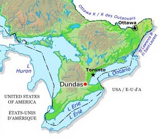
-
Article
Dunnville
Dunnville, Ont, urban area, population 5789 (2011c), 5729 (2006c). Dunnville was established in 1974 as a town in the Regional Municipality of Haldimand-Norfolk from the former townships of Canborough, Dunn, Moulton and Sherbrooke and the town of Dunnville.
"https://development.thecanadianencyclopedia.ca/images/tce_placeholder.jpg?v=e9dca980c9bdb3aa11e832e7ea94f5d9" // resources/views/front/categories/view.blade.php
https://development.thecanadianencyclopedia.ca/images/tce_placeholder.jpg?v=e9dca980c9bdb3aa11e832e7ea94f5d9
-
Article
Eagle Pass
Eagle Pass, elevation about 550 m, provides a corridor through the Gold Range in the Monashee Mountains between Shuswap Lake and the Columbia River, 12 km southwest of Revelstoke, British Columbia.
"https://d2ttikhf7xbzbs.cloudfront.net/media/media/1f3712f0-f1ac-4fba-a093-ff4c7cfec856.jpg" // resources/views/front/categories/view.blade.php
https://d2ttikhf7xbzbs.cloudfront.net/media/media/1f3712f0-f1ac-4fba-a093-ff4c7cfec856.jpg
-
Article
Earnscliffe
Earnscliffe, built in 1857 for Thomas MacKinnon, a successful businessman, was one of Ottawa's most impressive mansions of the mid-19th century.
"https://development.thecanadianencyclopedia.ca/images/tce_placeholder.jpg?v=e9dca980c9bdb3aa11e832e7ea94f5d9" // resources/views/front/categories/view.blade.php
https://development.thecanadianencyclopedia.ca/images/tce_placeholder.jpg?v=e9dca980c9bdb3aa11e832e7ea94f5d9
-
Article
East Gwillimbury
East Gwillimbury, Ontario, incorporated as a town in 1971, population 34,637 (2021 census), 23,991 (2016 census). Located in York Region, East Gwillimbury’s northern border is less than a kilometre from Lake Simcoe. Historic communities within East Gwillimbury include Sharon, Holland Landing, Queensville and Mount Albert. As of 2021, the town was Canada’s fastest growing municipality of over 5,000 people, with a population increase of over 44 per cent between 2016 and 2021. Throughout history, the East Gwillimbury area has been home to different Indigenous groups, namely the Wendat (Huron), Tionontati (Petun), Haudenosaunee and Anishinaabeg, including the Chippewas of Georgina Island First Nation. The land is part of the Williams Treaties (1923).
"https://d2ttikhf7xbzbs.cloudfront.net/EastGwillimbury/SharonTemple.jpg" // resources/views/front/categories/view.blade.php
https://d2ttikhf7xbzbs.cloudfront.net/EastGwillimbury/SharonTemple.jpg
-
Article
East York
East York, Ont, Urban Community within the city of Toronto. East York was a borough until it was merged in 1998 into the new city of Toronto.
"https://d2ttikhf7xbzbs.cloudfront.net/media/media/a7323b4e-dfc4-4ae9-83c8-83937b615bf9.jpg" // resources/views/front/categories/view.blade.php
https://d2ttikhf7xbzbs.cloudfront.net/media/media/a7323b4e-dfc4-4ae9-83c8-83937b615bf9.jpg
-
Article
Eastern Townships
The Eastern Townships region is located in the Appalachian hills of south-central Quebec, between Montreal and Quebec City. The townships extend from Granby to Lac Mégantic and from Drummondville to the US border.
"https://d2ttikhf7xbzbs.cloudfront.net/media/media/2235ed70-ba4f-43c4-81e1-53b22e3e71bd.jpg" // resources/views/front/categories/view.blade.php
https://d2ttikhf7xbzbs.cloudfront.net/media/media/2235ed70-ba4f-43c4-81e1-53b22e3e71bd.jpg
-
Article
Eastmain
Eastmain (or East Main) refers to the east shore of Hudson Bay, although in the 1680s the term was restricted to the vicinity of the Eastmain River. The corresponding reference to the west shore of Hudson Bay is the Westmain (West Main).
"https://development.thecanadianencyclopedia.ca/images/tce_placeholder.jpg?v=e9dca980c9bdb3aa11e832e7ea94f5d9" // resources/views/front/categories/view.blade.php
https://development.thecanadianencyclopedia.ca/images/tce_placeholder.jpg?v=e9dca980c9bdb3aa11e832e7ea94f5d9