Browse "Places"
-
Article
Husky Lakes
Husky Lakes, 880 km2, lie along the southern edge of the Tuktoyaktuk Peninsula, NWT, and drain into Liverpool Bay on the Beaufort Sea. Though commonly known as Husky Lakes, the name “Eskimo Lakes” still appears in certain maps and literature. (See also Eskimo.)
"https://development.thecanadianencyclopedia.ca/images/tce_placeholder.jpg?v=e9dca980c9bdb3aa11e832e7ea94f5d9" // resources/views/front/categories/view.blade.php
https://development.thecanadianencyclopedia.ca/images/tce_placeholder.jpg?v=e9dca980c9bdb3aa11e832e7ea94f5d9
-
Article
Espace GO
Espace GO. One of Montréal's main theatrical institutions, Espace GO, which has existed under this name since the early 1990s, stems from the Théâtre Expérimental des Femmes (TEF), whose heritage it preserves, in part.
"https://development.thecanadianencyclopedia.ca/images/tce_placeholder.jpg?v=e9dca980c9bdb3aa11e832e7ea94f5d9" // resources/views/front/categories/view.blade.php
https://development.thecanadianencyclopedia.ca/images/tce_placeholder.jpg?v=e9dca980c9bdb3aa11e832e7ea94f5d9
-
Article
Espace Libre
Espace Libre. A space for creation and dissemination dedicated to experimental theatre and research, Espace Libre marked the 30th anniversary of its founding in 2009.
"https://development.thecanadianencyclopedia.ca/images/tce_placeholder.jpg?v=e9dca980c9bdb3aa11e832e7ea94f5d9" // resources/views/front/categories/view.blade.php
https://development.thecanadianencyclopedia.ca/images/tce_placeholder.jpg?v=e9dca980c9bdb3aa11e832e7ea94f5d9
-
Article
Espanola
Espanola, Ont, incorporated as a town in 1958, population 5364 (2011c), 5314 (2006c). The Town of Espanola is located 69 km west of Sudbury on the Spanish River.
"https://development.thecanadianencyclopedia.ca/images/tce_placeholder.jpg?v=e9dca980c9bdb3aa11e832e7ea94f5d9" // resources/views/front/categories/view.blade.php
https://development.thecanadianencyclopedia.ca/images/tce_placeholder.jpg?v=e9dca980c9bdb3aa11e832e7ea94f5d9
-
Article
Esquimalt
Esquimalt, British Columbia, incorporated as a district municipality in 1912, population 17,533 (2021 census), 17,655 (2016 census). The Township of Esquimalt is located on the southern tip of Vancouver Island adjacent to Victoria. It was one of the earliest residential areas to be established in Metropolitan Victoria and its excellent harbour has made it an important Pacific Coast naval establishment. Esquimalt is governed by a mayor and six councillors and shares some responsibilities with the Capital Regional District.
"https://d2ttikhf7xbzbs.cloudfront.net/media/media/f9d724d8-4cdb-41f1-a12e-cbff359501cd.jpg" // resources/views/front/categories/view.blade.php
https://d2ttikhf7xbzbs.cloudfront.net/media/media/f9d724d8-4cdb-41f1-a12e-cbff359501cd.jpg
-
Article
Esterhazy
Esterhazy, Sask, incorporated as a village in 1903 and as a town in 1957, population 2472 (2011c), 2336 (2006c). The Town of Esterhazy is located in east-central Saskatchewan, 83 km southeast of YORKTON. It is named after Count
"https://development.thecanadianencyclopedia.ca/images/tce_placeholder.jpg?v=e9dca980c9bdb3aa11e832e7ea94f5d9" // resources/views/front/categories/view.blade.php
https://development.thecanadianencyclopedia.ca/images/tce_placeholder.jpg?v=e9dca980c9bdb3aa11e832e7ea94f5d9
-
Article
Estevan
The townsite was surveyed in 1892 where the Soo Line of the Canadian Pacific Railway crossed the river, and grew steadily from that date, largely because of its dual role as a trading and energy centre.
"https://development.thecanadianencyclopedia.ca/images/tce_placeholder.jpg?v=e9dca980c9bdb3aa11e832e7ea94f5d9" // resources/views/front/categories/view.blade.php
https://development.thecanadianencyclopedia.ca/images/tce_placeholder.jpg?v=e9dca980c9bdb3aa11e832e7ea94f5d9
-
Article
Evergreen Brick Works
Located in Toronto's Don Valley, Evergreen Brick Works helps to reconnect Torontonians with the rich natural heritage and invaluable recreational opportunities in the Don Valley Watershed.
"https://d2ttikhf7xbzbs.cloudfront.net/media/media/468f3871-9249-4aef-8e77-ac29d9cb87ad.jpg" // resources/views/front/categories/view.blade.php
https://d2ttikhf7xbzbs.cloudfront.net/media/media/468f3871-9249-4aef-8e77-ac29d9cb87ad.jpg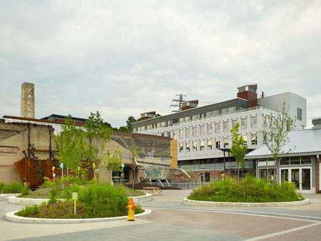
-
Article
Exeter
Exeter, Ont, Town, urban area, population 4785 (2011c), 4657 (2006c). Exeter is located approximately 50 km north of LONDON.
"https://development.thecanadianencyclopedia.ca/images/tce_placeholder.jpg?v=e9dca980c9bdb3aa11e832e7ea94f5d9" // resources/views/front/categories/view.blade.php
https://development.thecanadianencyclopedia.ca/images/tce_placeholder.jpg?v=e9dca980c9bdb3aa11e832e7ea94f5d9
-
Article
Exploits River
The Exploits River, 246 km long is the longest river on the Island of Newfoundland. Its tributaries, the Lloyds and Victoria rivers, rise in the southwest corner of the Island and flow northeast into Red Indian Lake (250 km2).
"https://development.thecanadianencyclopedia.ca/images/tce_placeholder.jpg?v=e9dca980c9bdb3aa11e832e7ea94f5d9" // resources/views/front/categories/view.blade.php
https://development.thecanadianencyclopedia.ca/images/tce_placeholder.jpg?v=e9dca980c9bdb3aa11e832e7ea94f5d9
-
Article
Factory Theatre
Gass, along with co-founder Frank Trotz, borrowed $3000 to launch the company, whose first home was in a greasy former candle factory above an auto-body shop at 374 Dupont Street.
"https://d2ttikhf7xbzbs.cloudfront.net/media/media/314afe7b-e739-4d34-b72e-0f60a9af41fc.jpg" // resources/views/front/categories/view.blade.php
https://d2ttikhf7xbzbs.cloudfront.net/media/media/314afe7b-e739-4d34-b72e-0f60a9af41fc.jpg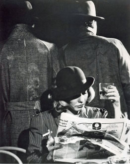
-
Article
Fairvale
Fairvale, NB, is a community located on the Kennebecasis River within the town of ROTHESAY. Settled in 1819, it remained a farming area until early in the 20th century.
"https://development.thecanadianencyclopedia.ca/images/tce_placeholder.jpg?v=e9dca980c9bdb3aa11e832e7ea94f5d9" // resources/views/front/categories/view.blade.php
https://development.thecanadianencyclopedia.ca/images/tce_placeholder.jpg?v=e9dca980c9bdb3aa11e832e7ea94f5d9
-
Article
Fairview
Fairview, Alta, incorporated as a town in 1949, population 3162 (2011c), 3297 (2006c). The Town of Fairview is located in the Peace River country of northern Alberta, 110 km north of Grande Prairie.
"https://d2ttikhf7xbzbs.cloudfront.net/media/media/56b28e9a-8c1f-4ea3-af36-a3dcbbb09be4.jpg" // resources/views/front/categories/view.blade.php
https://d2ttikhf7xbzbs.cloudfront.net/media/media/56b28e9a-8c1f-4ea3-af36-a3dcbbb09be4.jpg
-
Article
Fairweather Mountain
Fairweather Mountain, elevation 4663 m, is located at the southern end of the St Elias Range, on the BC-Alaska border, where a segment of the BC border juts southwest, nearly cutting off the Alaska Panhandle.
"https://development.thecanadianencyclopedia.ca/images/tce_placeholder.jpg?v=e9dca980c9bdb3aa11e832e7ea94f5d9" // resources/views/front/categories/view.blade.php
https://development.thecanadianencyclopedia.ca/images/tce_placeholder.jpg?v=e9dca980c9bdb3aa11e832e7ea94f5d9
-
Article
Falher
Falher, Alberta, incorporated as a village in 1923 and as a town in 1955, population 1,047 (2016 census), 1,075 (2011 census). The Town of Falher is located south of Peace River. It was named for Father Constant Falher, a Roman Catholic priest.
"https://d2ttikhf7xbzbs.cloudfront.net/media/media/a3fa5c75-39d0-45e6-8260-5d27e1e63d3c.jpg" // resources/views/front/categories/view.blade.php
https://d2ttikhf7xbzbs.cloudfront.net/media/media/a3fa5c75-39d0-45e6-8260-5d27e1e63d3c.jpg