Browse "Places"
-
Article
Fort Vancouver
Fort Vancouver, a HUDSON'S BAY CO fur-trade post, was originally constructed in 1825 by Dr. John McLoughlin about 150 km inland on the north bank of the Columbia River, 8 km above the mouth of the Willamette. In 1829, the
"https://d2ttikhf7xbzbs.cloudfront.net/media/media/8995b1e1-60ec-48e0-8b23-d944da85cc4d.jpg" // resources/views/front/categories/view.blade.php
https://d2ttikhf7xbzbs.cloudfront.net/media/media/8995b1e1-60ec-48e0-8b23-d944da85cc4d.jpg
-
Article
Fort Vermilion
Fort Vermilion, Alta, Unincorporated Place, population 727 (2011c), 714 (2006c). Fort Vermilion is located about 70 km east of HIGH LEVEL and is one of the communities of Mackenzie County. The name Fort Vermilion refers to the red ochre found in the area.
"https://d2ttikhf7xbzbs.cloudfront.net/media/media/7b54f899-613a-4dce-8a8b-8e0971b7f4fa.jpg" // resources/views/front/categories/view.blade.php
https://d2ttikhf7xbzbs.cloudfront.net/media/media/7b54f899-613a-4dce-8a8b-8e0971b7f4fa.jpg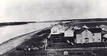
-
Article
Fort Victoria
In 1842, James DOUGLAS of the HUDSON'S BAY CO selected the port of Camosack (the harbour where Victoria now stands) as a new fur-trade post - eventually to replace FORT VANCOUVER as the company's Pacific headquarters and to bolster the British claim to VANCOUVER ISLAND.
"https://development.thecanadianencyclopedia.ca/images/tce_placeholder.jpg?v=e9dca980c9bdb3aa11e832e7ea94f5d9" // resources/views/front/categories/view.blade.php
https://development.thecanadianencyclopedia.ca/images/tce_placeholder.jpg?v=e9dca980c9bdb3aa11e832e7ea94f5d9
-
Article
Fort Walsh
Following the defeat of General George Custer (1876), the Mounted Police centered at Fort Walsh were called upon to mediate with refugee Sioux who had followed Chief SITTING BULL across the US border, thereby creating an international incident.
"https://d2ttikhf7xbzbs.cloudfront.net/media/media/b7bd4098-56cd-4e5e-a735-7d8ef4b040aa.jpg" // resources/views/front/categories/view.blade.php
https://d2ttikhf7xbzbs.cloudfront.net/media/media/b7bd4098-56cd-4e5e-a735-7d8ef4b040aa.jpg
-
Article
Fort Wellington National Historic Site of Canada
Fort Wellington National Historic Site, designated in 1920, was one of the first HISTORIC SITES in Canada to receive national recognition of its historical importance. The first Fort Wellington was built by the British at PRESCOTT, Ont, on the north bank of the St Lawrence River.
"https://development.thecanadianencyclopedia.ca/images/tce_placeholder.jpg?v=e9dca980c9bdb3aa11e832e7ea94f5d9" // resources/views/front/categories/view.blade.php
https://development.thecanadianencyclopedia.ca/images/tce_placeholder.jpg?v=e9dca980c9bdb3aa11e832e7ea94f5d9
-
Article
Fort Whoop-Up
Fort Whoop-Up, situated at the junction of the Belly (now Oldman) and St Mary rivers, near present-day Lethbridge, Alberta, was established in 1869 by John J. Healy and Alfred B. Hamilton of Montana.
"https://development.thecanadianencyclopedia.ca/images/tce_placeholder.jpg?v=e9dca980c9bdb3aa11e832e7ea94f5d9" // resources/views/front/categories/view.blade.php
https://development.thecanadianencyclopedia.ca/images/tce_placeholder.jpg?v=e9dca980c9bdb3aa11e832e7ea94f5d9
-
Article
Fort William
Named in 1807 after NWC chief superintendent William MCGILLIVRAY, Fort William occupied a pivotal place in the company's vast trading network. In 1816-17 Lord SELKIRK occupied Fort William for 10 months as a consequence of the SEVEN OAKS INCIDENT.
"https://d2ttikhf7xbzbs.cloudfront.net/media/media/7b13aa86-dd8f-4056-b650-3839e00b77e9.jpg" // resources/views/front/categories/view.blade.php
https://d2ttikhf7xbzbs.cloudfront.net/media/media/7b13aa86-dd8f-4056-b650-3839e00b77e9.jpg
-
Article
Fort York National Historic Site
The Fort York National Historic Site commemorates several British military installations which guarded the entrance to Toronto Harbour.
"https://d2ttikhf7xbzbs.cloudfront.net/media/media/a55f0fd3-041e-4936-ac4d-11d232bbdf0e.jpg" // resources/views/front/categories/view.blade.php
https://d2ttikhf7xbzbs.cloudfront.net/media/media/a55f0fd3-041e-4936-ac4d-11d232bbdf0e.jpg
-
Article
Forteau
Forteau, NL, incorporated as a town in 1997, population 429 (2011c), 448 (2006c). The Town of Forteau is a fishing and services centre on Forteau Bay in southern Labrador, 25 km across the Strait of Belle Isle from insular Newfoundland.
"https://development.thecanadianencyclopedia.ca/images/tce_placeholder.jpg?v=e9dca980c9bdb3aa11e832e7ea94f5d9" // resources/views/front/categories/view.blade.php
https://development.thecanadianencyclopedia.ca/images/tce_placeholder.jpg?v=e9dca980c9bdb3aa11e832e7ea94f5d9
-
Article
Fortification
Although the barrier posed by these walls was sometimes increased by setting a ditch below their outer faces, fortification did not progress beyond this rather simple conception until the 16th century.
"https://d2ttikhf7xbzbs.cloudfront.net/media/media/528fc0db-255d-4206-bfde-3fcb0b932747.jpg" // resources/views/front/categories/view.blade.php
https://d2ttikhf7xbzbs.cloudfront.net/media/media/528fc0db-255d-4206-bfde-3fcb0b932747.jpg
-
Article
Fortune
Fortune, NL, incorporated as a town in 1946, population 1442 (2011c), 1458 (2006c). The Town of Fortune is located on the west end of the Burin Peninsula at the mouth of Fortune Bay.
"https://development.thecanadianencyclopedia.ca/images/tce_placeholder.jpg?v=e9dca980c9bdb3aa11e832e7ea94f5d9" // resources/views/front/categories/view.blade.php
https://development.thecanadianencyclopedia.ca/images/tce_placeholder.jpg?v=e9dca980c9bdb3aa11e832e7ea94f5d9
-
Article
Forum
Forum. Montreal arena, home of the famous hockey team the Canadiens, and the site of many sporting, musical, and stage events. Situated at the corner of Atwater and Ste-Catherine streets, it is the property of the Canadian Arena Co.
"https://development.thecanadianencyclopedia.ca/images/tce_placeholder.jpg?v=e9dca980c9bdb3aa11e832e7ea94f5d9" // resources/views/front/categories/view.blade.php
https://development.thecanadianencyclopedia.ca/images/tce_placeholder.jpg?v=e9dca980c9bdb3aa11e832e7ea94f5d9
-
Article
Fosheim Peninsula
The Fosheim Peninsula is located on the west coast of central Ellesmere Island, Nunavut.
"https://d2ttikhf7xbzbs.cloudfront.net/media/media/99c8f8a7-e4a8-4cab-85df-fa919f71879c.JPG" // resources/views/front/categories/view.blade.php
https://d2ttikhf7xbzbs.cloudfront.net/media/media/99c8f8a7-e4a8-4cab-85df-fa919f71879c.JPG
-
Article
Four Seasons Centre for the Performing Arts
Four Seasons Centre for the Performing Arts. Toronto opera house, situated at the southeast corner of Queen St West and University Avenue.
"https://d2ttikhf7xbzbs.cloudfront.net/media/media/f04c623d-d93a-4bb8-b3cc-b58f90a65d1a.jpg" // resources/views/front/categories/view.blade.php
https://d2ttikhf7xbzbs.cloudfront.net/media/media/f04c623d-d93a-4bb8-b3cc-b58f90a65d1a.jpg
-
Article
Fox Creek
Fox Creek, AB, incorporated as a town in 1967, population 1,639 (2021 census), 1,971 (2016 census). The Town of Fox Creek is located 74 km west of Whitecourt.
"https://development.thecanadianencyclopedia.ca/images/tce_placeholder.jpg?v=e9dca980c9bdb3aa11e832e7ea94f5d9" // resources/views/front/categories/view.blade.php
https://development.thecanadianencyclopedia.ca/images/tce_placeholder.jpg?v=e9dca980c9bdb3aa11e832e7ea94f5d9