Browse "Places"
-
Article
Greenfield Park
Greenfield Park, Qué, pop 16 978 (2001c), 17 337 (1996c), incorporated as a city in 1911, from January 2002, is a borough of the new city of Longueuil created by the amalgamation of 8 distinct municipalities. Greenfield Park is located opposite Île de Montréal on the South Shore of the St Lawrence River.
"https://d2ttikhf7xbzbs.cloudfront.net/media/media/066c39bd-0c7c-422e-b8db-dabafc5f4043.jpg" // resources/views/front/categories/view.blade.php
https://d2ttikhf7xbzbs.cloudfront.net/media/media/066c39bd-0c7c-422e-b8db-dabafc5f4043.jpg
-
Article
Greenland (Kalaallit Nunaat)
Greenland, also known as Kalaallit Nunaat, is the world’s largest island and Canada’s northeasterly neighbour. The capital city of Nuuk has a population of 19,604, though Greenland as a whole has a population of over 55,000 (2023). Primarily inhabited by Inuit and other Nordic Indigenous peoples, the island is under Danish sovereignty today. Known for its dramatic landscape and massive ice sheet, Greenland has been growing its tourism industry in recent years.
"https://d2ttikhf7xbzbs.cloudfront.net/greenland/dog-sledding.jpg" // resources/views/front/categories/view.blade.php
https://d2ttikhf7xbzbs.cloudfront.net/greenland/dog-sledding.jpg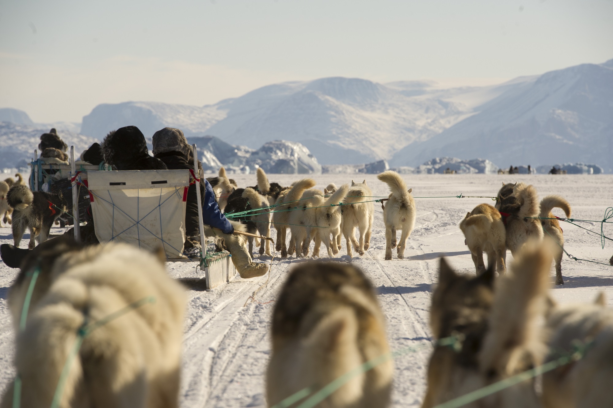
-
Article
Greenwood
Greenwood, BC, incorporated as a city in 1897, population 708 (2011c), 625 (2006c). The City of Greenwood is located 27 km west of GRAND FORKS on Highway 3. It grew as a result of the mining boom in the Boundary District in the 1890s and nearly died when the boom ended.
"https://d2ttikhf7xbzbs.cloudfront.net/media/media/e9c8f32a-e1a5-4721-8e46-8f3903b9c210.jpg" // resources/views/front/categories/view.blade.php
https://d2ttikhf7xbzbs.cloudfront.net/media/media/e9c8f32a-e1a5-4721-8e46-8f3903b9c210.jpg
-
Article
Griffintown
Griffintown was developed in the 19th century as a working-class Irish neighbourhood of Montréal. It underwent several attempts at urban revitalization from the 1980s onwards. Since 2010, there have been a number of controversial real estate developments in the neighbourhood. The neighbourhood is part of the Sud-Ouest and Ville-Marie boroughs of Montréal. It is located along the Lachine Canal, between Notre-Dame, McGill and Guy streets.
"https://d2ttikhf7xbzbs.cloudfront.net/View-2942.jpg" // resources/views/front/categories/view.blade.php
https://d2ttikhf7xbzbs.cloudfront.net/View-2942.jpg
-
Article
Grimsby
Grimsby, Ontario, incorporated as a town in 1970, population 25 325 (2011c), 23 937 (2006c). The Town of Grimsby is situated on the NIAGARA PENINSULA to the east of Hamilton.
"https://development.thecanadianencyclopedia.ca/images/tce_placeholder.jpg?v=e9dca980c9bdb3aa11e832e7ea94f5d9" // resources/views/front/categories/view.blade.php
https://development.thecanadianencyclopedia.ca/images/tce_placeholder.jpg?v=e9dca980c9bdb3aa11e832e7ea94f5d9
-
Article
Grimshaw
Grimshaw, Alta, incorporated as a town in 1953, population 2515 (2011c), 2537 (2006c). The Town of Grimshaw is located in the Peace River area 26 km west of the town of PEACE RIVER.
"https://d2ttikhf7xbzbs.cloudfront.net/media/media/2862aeaf-cace-4b85-aac6-6d4f4ad9c96e.jpg" // resources/views/front/categories/view.blade.php
https://d2ttikhf7xbzbs.cloudfront.net/media/media/2862aeaf-cace-4b85-aac6-6d4f4ad9c96e.jpg
-
Article
Grise Fiord
Grise Fiord, Nunavut, incorporated as a hamlet in 1987, population 130 (2011c), 141 (2006c). The Hamlet of Grise Fiord is located on the south coast of ELLESMERE ISLAND.
"https://d2ttikhf7xbzbs.cloudfront.net/media/media/81bcc22e-e2e4-4910-bb40-41c34dc9ce59.jpg" // resources/views/front/categories/view.blade.php
https://d2ttikhf7xbzbs.cloudfront.net/media/media/81bcc22e-e2e4-4910-bb40-41c34dc9ce59.jpg
-
Article
Gros Morne National Park
In 1970, an agreement was signed to establish Gros Morne National Park (1805 km2) on the west coast of Newfoundland. In 1987 Gros Morne National Park was designated a United Nations World Heritage Site because of its glacial and geologic history.
"https://d2ttikhf7xbzbs.cloudfront.net/media/media/efe7172c-e877-4f96-a652-0d67fdf65947.jpg" // resources/views/front/categories/view.blade.php
https://d2ttikhf7xbzbs.cloudfront.net/media/media/efe7172c-e877-4f96-a652-0d67fdf65947.jpg
-
Article
Guelph
Guelph, Ontario, incorporated as a city in 1879, population 143,740 (2021 census), 131,794 (2016 census). The City of Guelph, the seat of Wellington County, is located on the Speed River in south central Ontario, 96 km west of Toronto and 28 km east of Kitchener-Waterloo. This industrial and educational centre is set in the heart of a highly productive agricultural region.
"https://d2ttikhf7xbzbs.cloudfront.net/guelph/mapjpg.jpg" // resources/views/front/categories/view.blade.php
https://d2ttikhf7xbzbs.cloudfront.net/guelph/mapjpg.jpg
-
Article
Music in Guelph
Guelph, Ont. Founded 1827 by John Galt in the heart of agricultural Ontario and incorporated in 1879. In 1846 there were 1240 people living in Guelph. By 1988 the population had reached 80,786 including a large Italian.community.
"https://development.thecanadianencyclopedia.ca/images/tce_placeholder.jpg?v=e9dca980c9bdb3aa11e832e7ea94f5d9" // resources/views/front/categories/view.blade.php
https://development.thecanadianencyclopedia.ca/images/tce_placeholder.jpg?v=e9dca980c9bdb3aa11e832e7ea94f5d9
-
Article
Gulf
A gulf is a body of water partly surrounded by land and connected to an ocean or sea. This connection sometimes takes the form of a narrow passage called a strait. The nomenclature of water inlets can be inconsistent between sources. Sometimes, the terms gulf, bay and sea are used interchangeably. For example, the Arabian Sea and Hudson Bay can both be classified as gulfs. However, in most cases a gulf is deeper and larger than a bay and is also more enclosed from the ocean or sea to which it is connected. Because gulfs are partially surrounded by land, their waters are typically calmer than those of oceans. This makes them suitable for activities such as transportation, fishing and leisure.
"https://d2ttikhf7xbzbs.cloudfront.net/media/new_article_images/Gulf/GulfofStLawrence.jpg" // resources/views/front/categories/view.blade.php
https://d2ttikhf7xbzbs.cloudfront.net/media/new_article_images/Gulf/GulfofStLawrence.jpg
-
Article
Gulf Islands
Their bucolic charm, calm waters, rich bird and marine life and mild climate, in the driest zone on Canada's Pacific coast, have attracted homesteaders and cottagers since about 1859. Stands of tall timber growing in deep soil were logged early in this century.
"https://d2ttikhf7xbzbs.cloudfront.net/media/media/2eb4a133-4037-49ab-af23-cc43cde9708f.jpg" // resources/views/front/categories/view.blade.php
https://d2ttikhf7xbzbs.cloudfront.net/media/media/2eb4a133-4037-49ab-af23-cc43cde9708f.jpg
-
Article
Gulf Islands National Park Reserve
Gulf Islands National Park Reserve is located in the southern Gulf Islands between Vancouver Island and the BC mainland. Created in 2003 and formally established in 2010, the park encompasses 36 km2 of land and 26 km2 of adjacent waters.
"https://d2ttikhf7xbzbs.cloudfront.net/media/media/b6ad5290-ef67-42ea-b426-b83ffb3ceca7.jpg" // resources/views/front/categories/view.blade.php
https://d2ttikhf7xbzbs.cloudfront.net/media/media/b6ad5290-ef67-42ea-b426-b83ffb3ceca7.jpg
-
Article
Gulf of Boothia
The Gulf of Boothia is entered through Prince Regent Inlet. To the east it is bounded by the northwest coast of Baffin Island, and to the west by the Boothia Peninsula. Depths are generally about 275 m, decreasing southward.
"https://development.thecanadianencyclopedia.ca/images/tce_placeholder.jpg?v=e9dca980c9bdb3aa11e832e7ea94f5d9" // resources/views/front/categories/view.blade.php
https://development.thecanadianencyclopedia.ca/images/tce_placeholder.jpg?v=e9dca980c9bdb3aa11e832e7ea94f5d9
-
Article
Gulf of St Lawrence
The Gulf of St Lawrence, a large (250,000 km2), roughly triangular inland sea receiving on average 10,100 m3/s of fresh water from the St. Lawrence River at its northwest apex, is connected to the Atlantic by the Strait of Belle Isle at the northeast and Cabot Strait at the southeast corners.
"https://d2ttikhf7xbzbs.cloudfront.net/gulfofstlawrence/Gulf-of-St-Lawrence.jpg" // resources/views/front/categories/view.blade.php
https://d2ttikhf7xbzbs.cloudfront.net/gulfofstlawrence/Gulf-of-St-Lawrence.jpg