Browse "Places"
-
Article
Hamilton
Hamilton, Ontario, incorporated as a city in 1846, population 569,353 (2021 census), 536,917 (2016 census). The City of Hamilton is situated at the west end of Lake Ontario, on Burlington Bay, 68 km southwest of Toronto, and 66 km west of Niagara Falls and the American border. As part of the reorganization of municipal governments in Ontario, the boundaries of the city were enlarged in 2001 to include much of the surrounding suburban and rural area, including the former towns of Ancaster, Dundas, Flamborough and Stoney Creek, and the former township of Glanbrook. The city is Canada's largest steel producer and a major Great Lakes port.
"https://d2ttikhf7xbzbs.cloudfront.net/media/media/43375d5d-a5ce-46af-9009-c05cc2f3957b.jpg" // resources/views/front/categories/view.blade.php
https://d2ttikhf7xbzbs.cloudfront.net/media/media/43375d5d-a5ce-46af-9009-c05cc2f3957b.jpg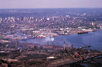
-
Article
Hamilton Inlet
Hamilton Inlet, together with Lk Melville, forms the largest estuary, over 250 km long, 40 km wide (at the western end) and 150 m deep, on the Labrador coast.
"https://development.thecanadianencyclopedia.ca/images/tce_placeholder.jpg?v=e9dca980c9bdb3aa11e832e7ea94f5d9" // resources/views/front/categories/view.blade.php
https://development.thecanadianencyclopedia.ca/images/tce_placeholder.jpg?v=e9dca980c9bdb3aa11e832e7ea94f5d9
-
Article
Music in Hamilton
City on Lake Ontario with a natural bay as harbour. Taking its name from George H. Hamilton (1787-1835), who laid it out in 1813, the town was incorporated as a city in 1846 when, with a population of 10,000, it was the second-largest city in Upper Canada.
"https://development.thecanadianencyclopedia.ca/images/tce_placeholder.jpg?v=e9dca980c9bdb3aa11e832e7ea94f5d9" // resources/views/front/categories/view.blade.php
https://development.thecanadianencyclopedia.ca/images/tce_placeholder.jpg?v=e9dca980c9bdb3aa11e832e7ea94f5d9
-
Article
Hamilton Place
Hamilton Place (formally Ronald V. Joyce Centre for the Performing Arts at Hamilton Place). Multi-purpose arts centre, situated on Main St in downtown Hamilton, Ont.
"https://development.thecanadianencyclopedia.ca/images/tce_placeholder.jpg?v=e9dca980c9bdb3aa11e832e7ea94f5d9" // resources/views/front/categories/view.blade.php
https://development.thecanadianencyclopedia.ca/images/tce_placeholder.jpg?v=e9dca980c9bdb3aa11e832e7ea94f5d9
-
Article
Hampton
Hampton, NB, incorporated as a town in 1991, population 4292 (2011c), 4004 (2006c). The Town of Hampton is situated 37 km northeast of SAINT JOHN on the Kennebecasis River.
"https://development.thecanadianencyclopedia.ca/images/tce_placeholder.jpg?v=e9dca980c9bdb3aa11e832e7ea94f5d9" // resources/views/front/categories/view.blade.php
https://development.thecanadianencyclopedia.ca/images/tce_placeholder.jpg?v=e9dca980c9bdb3aa11e832e7ea94f5d9
-
Article
Hanna
Hanna, Alta, incorporated as a town in 1914, population 2673 (2011c), 2847 (2006c). The Town of Hanna is situated 219 km northeast of Calgary and was named after David B. HANNA, 3rd vice-president of the Canadian Northern Railway, and was first settled in 1912.
"https://development.thecanadianencyclopedia.ca/images/tce_placeholder.jpg?v=e9dca980c9bdb3aa11e832e7ea94f5d9" // resources/views/front/categories/view.blade.php
https://development.thecanadianencyclopedia.ca/images/tce_placeholder.jpg?v=e9dca980c9bdb3aa11e832e7ea94f5d9
-
Article
Hanover (Man)
Hanover, Manitoba, incorporated as a rural municipality in 1881, population 14 026 (2011c), 11 871 (2006c). The Rural Municipality of Hanover is located southeast of Winnipeg, encompasses the communities of Blumenort, Grunthal, Kleefeld, Mitchell, New Bothwell, Randolph and Sarto.
"https://development.thecanadianencyclopedia.ca/images/tce_placeholder.jpg?v=e9dca980c9bdb3aa11e832e7ea94f5d9" // resources/views/front/categories/view.blade.php
https://development.thecanadianencyclopedia.ca/images/tce_placeholder.jpg?v=e9dca980c9bdb3aa11e832e7ea94f5d9
-
Article
Hanover (Ont)
Hanover, Ont, incorporated as a town in 1904, population 7490 (2011c), 7147 (2006c). The Town of Hanover is located 70 km southwest of OWEN SOUND on the Saugeen River.
"https://d2ttikhf7xbzbs.cloudfront.net/media/media/0ae492cf-0c8f-489c-9da4-cdd28d818051.jpg" // resources/views/front/categories/view.blade.php
https://d2ttikhf7xbzbs.cloudfront.net/media/media/0ae492cf-0c8f-489c-9da4-cdd28d818051.jpg
-
Article
Hans Island
Hans Island, Nunavut, is a tiny (1.2 km2), unpopulated island south of the 81st parallel in the Kennedy Channel (the northern part of Nares Strait), almost equidistant between Ellesmere Island and Greenland. The Greenlandic word for the island is Tartupaluk. (Greenlandic is a language spoken by Greenland Inuit.) For decades, both Canada and Denmark claimed ownership of the island. On 14 June 2022, however, the two countries settled the dispute, dividing the island roughly equally between them. (See also Canadian Arctic Sovereignty.)
"https://d2ttikhf7xbzbs.cloudfront.net/media/media/951d0121-b454-4f9e-ac31-2c7aec13a96d.jpg" // resources/views/front/categories/view.blade.php
https://d2ttikhf7xbzbs.cloudfront.net/media/media/951d0121-b454-4f9e-ac31-2c7aec13a96d.jpg
-
Article
Happy Valley-Goose Bay
Happy Valley-Goose Bay, Newfoundland and Labrador, incorporated as a town in 1973, population 8,109 (2016 census), 7,552 (2011 census). The town of Happy Valley-Goose Bay is the result of the amalgamation of two towns situated at the western end of Hamilton Inlet, Labrador. The community began with the construction of an air base during the Second World War. It remains home to a Canadian Forces Base and a small civilian population.
"https://d2ttikhf7xbzbs.cloudfront.net/media/media/dcdb9156-1ed7-43df-b8d3-36f7d617cd41.jpg" // resources/views/front/categories/view.blade.php
https://d2ttikhf7xbzbs.cloudfront.net/media/media/dcdb9156-1ed7-43df-b8d3-36f7d617cd41.jpg
-
Article
Harbour Breton
Harbour Breton, NL, incorporated as a town in 1952, population 1711 (2011c), 1877 (2006c). The Town of Harbour Breton is situated around a protected harbour near the mouth of Fortune Bay on Newfoundland's south coast.
"https://development.thecanadianencyclopedia.ca/images/tce_placeholder.jpg?v=e9dca980c9bdb3aa11e832e7ea94f5d9" // resources/views/front/categories/view.blade.php
https://development.thecanadianencyclopedia.ca/images/tce_placeholder.jpg?v=e9dca980c9bdb3aa11e832e7ea94f5d9
-
Article
Harbour Grace
Harbour Grace, NL, incorporated as a town in 1945, population 3131 (2011c), 3074 (2006c). The Town of Harbour Grace, with its commodious harbour in western Conception Bay, was named for the French Havre de Grâce.
"https://development.thecanadianencyclopedia.ca/images/tce_placeholder.jpg?v=e9dca980c9bdb3aa11e832e7ea94f5d9" // resources/views/front/categories/view.blade.php
https://development.thecanadianencyclopedia.ca/images/tce_placeholder.jpg?v=e9dca980c9bdb3aa11e832e7ea94f5d9
-
Article
Harrison River
Harrison River, 15 km long, flows SW from Harrison Lk to join the Fraser River about 100 km upriver from Vancouver in southern BC.
"https://development.thecanadianencyclopedia.ca/images/tce_placeholder.jpg?v=e9dca980c9bdb3aa11e832e7ea94f5d9" // resources/views/front/categories/view.blade.php
https://development.thecanadianencyclopedia.ca/images/tce_placeholder.jpg?v=e9dca980c9bdb3aa11e832e7ea94f5d9
-
Article
Hart House
Hart House, on UNIVERSITY OF TORONTO campus, was designed by the architectural firm of SPROATT AND ROLPH and was built 1911-19. Soldier's Tower, a memorial to the university's WWI dead, was added in 1924. Endowed by the Massey
"https://d2ttikhf7xbzbs.cloudfront.net/media/media/8db3f498-ce7c-4adf-a6b8-396d1782e4bd.jpg" // resources/views/front/categories/view.blade.php
https://d2ttikhf7xbzbs.cloudfront.net/media/media/8db3f498-ce7c-4adf-a6b8-396d1782e4bd.jpg
-
Article
Hart House
Hart House's facilities include the Great Hall located in the East Wing which functions as an event venue, conference centre, and concert hall and houses a Steinway grand piano. The Music Room in the West Wing also boasts a grand piano, and is used for smaller concerts, lectures and events.
"https://d2ttikhf7xbzbs.cloudfront.net/media/media/8db3f498-ce7c-4adf-a6b8-396d1782e4bd.jpg" // resources/views/front/categories/view.blade.php
https://d2ttikhf7xbzbs.cloudfront.net/media/media/8db3f498-ce7c-4adf-a6b8-396d1782e4bd.jpg