Browse "Places"
-
Article
Juan de Fuca Strait
Juan de Fuca Strait is an inlet of the Pacific Ocean between Vancouver Island and Washington State, connecting the Strait of Georgia and Puget Sound to the outer ocean.
"https://development.thecanadianencyclopedia.ca/images/tce_placeholder.jpg?v=e9dca980c9bdb3aa11e832e7ea94f5d9" // resources/views/front/categories/view.blade.php
https://development.thecanadianencyclopedia.ca/images/tce_placeholder.jpg?v=e9dca980c9bdb3aa11e832e7ea94f5d9
-
Article
Jumbo Pass
Jumbo Pass, elevation 2,270 m, is situated in the central Purcell Mountains of British Columbia.
"https://development.thecanadianencyclopedia.ca/images/tce_placeholder.jpg?v=e9dca980c9bdb3aa11e832e7ea94f5d9" // resources/views/front/categories/view.blade.php
https://development.thecanadianencyclopedia.ca/images/tce_placeholder.jpg?v=e9dca980c9bdb3aa11e832e7ea94f5d9
-
Article
Canada on D-Day: Juno Beach
Juno Beach was the Allied code name for a 10 km stretch of French coastline assaulted by Canadian soldiers on D-Day, 6 June 1944, during the Second World War. The Canadian Army’s 3rd Infantry Division and 2nd Armoured Brigade seized the beach and its seaside villages while under intense fire from German defenders — an extraordinary example of military skill, reinforced by countless acts of personal courage. The 3rd Infantry Division took heavy casualties in its first wave of attack but took control of the beach by the end of the day. More than 14,000 Canadian soldiers landed or parachuted into France on D-Day. The Royal Canadian Navy contributed 110 warships and 10,000 sailors and the RCAF contributed 15 fighter and fighter-bomber squadrons to the assault. There were 1,074 Canadian casualties, including 359 killed.
"https://d2ttikhf7xbzbs.cloudfront.net/media/media/f6f8902f-029b-4666-8ab3-5ccd0711dda3.jpg" // resources/views/front/categories/view.blade.php
https://d2ttikhf7xbzbs.cloudfront.net/media/media/f6f8902f-029b-4666-8ab3-5ccd0711dda3.jpg
-
Article
Kainai Nation (Blood Tribe)
The Kainai (G-ai-nah) Nation, otherwise known as the Blood Tribe, is a First Nation based in southern Alberta. Kainai Nation holds two reserves, Blood 148 and Blood 148A. Blood 148, the nation’s primary reserve, is the largest First Nation reserve by area in Canada. It covers 1,342.9 km², and is located southwest of the city of Lethbridge, north of the town of Cardston, and east of Pincher Creek. The nation’s second reserve is known as a “timber limit” and is used for hunting and fishing. As of 2021, there are 8,517 people living on the primary reserve, making it one of the most populous reserves in Canada. In total, Kainai Nation has 12,738 registered band members. (See also Reserves in Alberta.) The Kainai Nation is a signatory to Treaty 7. Mi’k ai’stoowa (Red Crow) signed on behalf of the nation in 1877. ( See also History of Kainai Nation (Blood Tribe).)
"https://d2ttikhf7xbzbs.cloudfront.net/media/new_article_images/ReservesInAlberta/Sundance.jpg" // resources/views/front/categories/view.blade.php
https://d2ttikhf7xbzbs.cloudfront.net/media/new_article_images/ReservesInAlberta/Sundance.jpg
-
Article
Kamloops
Kamloops, BC, incorporated as a city in 1893, population 97,902 (2021 census), 90,280 (2016 census). The City of Kamloops amalgamated with North Kamloops in 1967 and in 1973 with surrounding residential areas to form the present city of Kamloops. It is located in southern British Columbia 355 km northeast of Vancouver via the Coquihalla highway. The city is situated at the confluence of the North and South Thompson rivers near their entrance into Kamloops Lake. The Kamloops Reserve 1, home to some members of the Tk'emlúps te Secwépemc First Nation, is adjacent to the city, on the northeast corner of the river junction.
"https://development.thecanadianencyclopedia.ca/images/tce_placeholder.jpg?v=e9dca980c9bdb3aa11e832e7ea94f5d9" // resources/views/front/categories/view.blade.php
https://development.thecanadianencyclopedia.ca/images/tce_placeholder.jpg?v=e9dca980c9bdb3aa11e832e7ea94f5d9
-
Article
Kamouraska (Qué)
In 1849 the first superior court outside Québec City was established here. Incorporated as a village in 1858, Kamouraska was an important tourist area in the 19th and early 20th centuries. People came to admire the countryside, breathe the salt air and bathe in the sea.
"https://d2ttikhf7xbzbs.cloudfront.net/media/media/807c11be-1891-494f-a926-99f1c1ccd160.jpg" // resources/views/front/categories/view.blade.php
https://d2ttikhf7xbzbs.cloudfront.net/media/media/807c11be-1891-494f-a926-99f1c1ccd160.jpg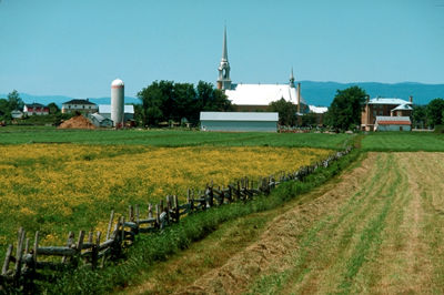
-
Article
Kamsack
Kamsack primarily serves as an agricultural service centre for the surrounding district, which contains both grain and mixed farms.
"https://development.thecanadianencyclopedia.ca/images/tce_placeholder.jpg?v=e9dca980c9bdb3aa11e832e7ea94f5d9" // resources/views/front/categories/view.blade.php
https://development.thecanadianencyclopedia.ca/images/tce_placeholder.jpg?v=e9dca980c9bdb3aa11e832e7ea94f5d9
-
Article
Kane Basin
Kane Basin is a broad expanse of water, about 3900 km2, that leads northward between the eastern shore of ELLESMERE ISLAND and the west coast of Greenland. It is relatively shallow; for the most part depths reach 180 m. Ice conditions are a severe impediment to navigation.
"https://development.thecanadianencyclopedia.ca/images/tce_placeholder.jpg?v=e9dca980c9bdb3aa11e832e7ea94f5d9" // resources/views/front/categories/view.blade.php
https://development.thecanadianencyclopedia.ca/images/tce_placeholder.jpg?v=e9dca980c9bdb3aa11e832e7ea94f5d9
-
Article
Kangiqsualujjuaq
A Hudson's Bay Company's trading post operated intermittently in the area from 1838 to 1952. A sawmill near the trading post attracted a permanent population, and the establishment of an arctic CHAR fishing co-operative in 1959 cemented the community's existence.
"https://d2ttikhf7xbzbs.cloudfront.net/media/media/2ddd79fe-a676-4b02-976a-d5c5001ed6a2.jpg" // resources/views/front/categories/view.blade.php
https://d2ttikhf7xbzbs.cloudfront.net/media/media/2ddd79fe-a676-4b02-976a-d5c5001ed6a2.jpg
-
Article
Kapuskasing
Kapuskasing, Ont, incorporated as a town in 1921, population 8196 (2011c), 8509 (2006c). The Town of Kapuskasing is located on the Kapuskasing River, 493 km northwest of North Bay.
"https://development.thecanadianencyclopedia.ca/images/tce_placeholder.jpg?v=e9dca980c9bdb3aa11e832e7ea94f5d9" // resources/views/front/categories/view.blade.php
https://development.thecanadianencyclopedia.ca/images/tce_placeholder.jpg?v=e9dca980c9bdb3aa11e832e7ea94f5d9
-
Article
Kaslo
Kaslo, BC, incorporated as a village in 1959, population 1026 (2011c), 1072 (2006c). The Village of Kaslo is located 70 km north of Nelson, overlooking KOOTENAY LAKE. It was established in 1892 to service the silver-mining boom sweeping the Kootenays. The origin of the name is unclear.
"https://development.thecanadianencyclopedia.ca/images/tce_placeholder.jpg?v=e9dca980c9bdb3aa11e832e7ea94f5d9" // resources/views/front/categories/view.blade.php
https://development.thecanadianencyclopedia.ca/images/tce_placeholder.jpg?v=e9dca980c9bdb3aa11e832e7ea94f5d9
-
Article
Kawartha Lakes
The Kawartha Lakes are a chain of interconnected lakes in south-central Ontario, forming the Trent River's upper watershed. These lakes range in size from 2 to 83 km2. Most of the lakes are located in the city of Kawartha Lakes and Peterborough County.
"https://d2ttikhf7xbzbs.cloudfront.net/kawarthalakes/Bobcaygeon.jpg" // resources/views/front/categories/view.blade.php
https://d2ttikhf7xbzbs.cloudfront.net/kawarthalakes/Bobcaygeon.jpg
-
Article
Kawartha Lakes (Ont)
Kawartha Lakes, Ontario, incorporated as a city in 2001, population 75,423 (2016 census), 73,214 (2011 census). The city of Kawartha Lakes is located almost immediately west and north of Peterborough. Kawartha Lakes was created in 2001 by the amalgamation of all the municipalities in the former county of Victoria, including Lindsay, Bobcaygeon, Verulam, Fenelon Falls, Omemee, Sturgeon Point, Woodville and 10 townships. The name is taken from the name given to a group of lakes in the area, the Kawartha Lakes. The name was given to these lakes in 1895.
"https://d2ttikhf7xbzbs.cloudfront.net/media/media/a444015a-7bdd-448d-a491-b495edd22dee.jpg" // resources/views/front/categories/view.blade.php
https://d2ttikhf7xbzbs.cloudfront.net/media/media/a444015a-7bdd-448d-a491-b495edd22dee.jpg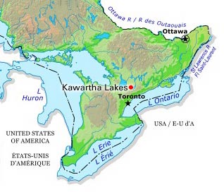
-
Article
Kazan River
Kazan River, 850 km long, rises near Kasba Lake in southern Nunavut near the Saskatchewan border. Flowing north it follows an irregular course through several lakes, draining a large part of the Barren Lands.
"https://development.thecanadianencyclopedia.ca/images/tce_placeholder.jpg?v=e9dca980c9bdb3aa11e832e7ea94f5d9" // resources/views/front/categories/view.blade.php
https://development.thecanadianencyclopedia.ca/images/tce_placeholder.jpg?v=e9dca980c9bdb3aa11e832e7ea94f5d9
-
Article
Kedgwick
Kedgwick, NB, incorporated as a village in 1966, population 993 (2011c), 1146 (2006c). The Village of Kedgwick is a francophone community located 74 km southwest of CAMPBELLTON.
"https://development.thecanadianencyclopedia.ca/images/tce_placeholder.jpg?v=e9dca980c9bdb3aa11e832e7ea94f5d9" // resources/views/front/categories/view.blade.php
https://development.thecanadianencyclopedia.ca/images/tce_placeholder.jpg?v=e9dca980c9bdb3aa11e832e7ea94f5d9