Browse "Places"
-
Article
Le Gardeur
First set up as the parish municipality of Saint-Paul-l'Ermite in 1857, it was incorporated as a city under the same name in 1973 before changing its designation to Le Gardeur in 1978.
"https://development.thecanadianencyclopedia.ca/images/tce_placeholder.jpg?v=e9dca980c9bdb3aa11e832e7ea94f5d9" // resources/views/front/categories/view.blade.php
https://development.thecanadianencyclopedia.ca/images/tce_placeholder.jpg?v=e9dca980c9bdb3aa11e832e7ea94f5d9
-
Article
Leaf Rapids
Leaf Rapids, Manitoba, incorporated as a town in 1974, population 453 (2011c), 539 (2006c). The Town of Leaf Rapids is a mining community located 3 km south of the CHURCHILL RIVER on the Canadian Shield and 976 km northwest of Winnipeg.
"https://development.thecanadianencyclopedia.ca/images/tce_placeholder.jpg?v=e9dca980c9bdb3aa11e832e7ea94f5d9" // resources/views/front/categories/view.blade.php
https://development.thecanadianencyclopedia.ca/images/tce_placeholder.jpg?v=e9dca980c9bdb3aa11e832e7ea94f5d9
-
Article
Leamington
Leamington, Ont, incorporated as a town in 1890 and as a municipality in 1999, population 28 403 (2011c), 28 833 (2006c). The Municipality of Leamington is located on the north shore of LAKE ERIE, 54 km southeast of WINDSOR.
"https://development.thecanadianencyclopedia.ca/images/tce_placeholder.jpg?v=e9dca980c9bdb3aa11e832e7ea94f5d9" // resources/views/front/categories/view.blade.php
https://development.thecanadianencyclopedia.ca/images/tce_placeholder.jpg?v=e9dca980c9bdb3aa11e832e7ea94f5d9
-
Article
Leduc
Leduc, Alta, incorporated as a town in 1906 and as a city in 1983, population 24 279 (2011c), 16 967 (2006c). The City of Leduc is located 30 km south of EDMONTON. Originally a telegraph terminus and stop on the Calgary and Edmonton Railway (1891), the community grew as an agricultural centre.
"https://d2ttikhf7xbzbs.cloudfront.net/media/media/44470b4c-f3a6-43c4-b226-5b07849fd3f2.jpg" // resources/views/front/categories/view.blade.php
https://d2ttikhf7xbzbs.cloudfront.net/media/media/44470b4c-f3a6-43c4-b226-5b07849fd3f2.jpg
-
Article
Leitch Collieries
Leitch Collieries, an Alberta provincial HISTORIC SITE, is located near the entrance to the municipality of CROWSNEST PASS. This mine site is now abandoned, but in 1907, when it opened, it was considered one of the most advanced and up-to-date coal and coke operations in Canada.
"https://development.thecanadianencyclopedia.ca/images/tce_placeholder.jpg?v=e9dca980c9bdb3aa11e832e7ea94f5d9" // resources/views/front/categories/view.blade.php
https://development.thecanadianencyclopedia.ca/images/tce_placeholder.jpg?v=e9dca980c9bdb3aa11e832e7ea94f5d9
-
Article
Lennoxville
The Abenaki and the French missionaries often used the site because it was a focal point for canoes and small boats using the tributaries of the Saint-François. A sawmill and forest products plant (lumber and potash) preceded the founding of the first village by LOYALISTS around 1794.
"https://development.thecanadianencyclopedia.ca/images/tce_placeholder.jpg?v=e9dca980c9bdb3aa11e832e7ea94f5d9" // resources/views/front/categories/view.blade.php
https://development.thecanadianencyclopedia.ca/images/tce_placeholder.jpg?v=e9dca980c9bdb3aa11e832e7ea94f5d9
-
Article
Reford Gardens National Historic Site
These English-style gardens have been a national historic site of Canada since 1995. They cover an area of 18 hectares and are located in the Grand-Métis municipality of Québec, at the entrance to the Gaspé Peninsula.
"https://d2ttikhf7xbzbs.cloudfront.net/media/media/b121f5aa-bf90-422c-96f8-87c9ab1fb2c4.jpg" // resources/views/front/categories/view.blade.php
https://d2ttikhf7xbzbs.cloudfront.net/media/media/b121f5aa-bf90-422c-96f8-87c9ab1fb2c4.jpg
-
Article
Lesser Slave Lake
The earliest non-Indigenous settlement in the area evolved at the west end of the lake, off Buffalo Bay, where the North West Company established a post (1802) and the Roman Catholic Church followed with a mission (1872).
"https://d2ttikhf7xbzbs.cloudfront.net/media/media/4ec4a212-b4ef-4fde-844a-ba30ef433515.jpg" // resources/views/front/categories/view.blade.php
https://d2ttikhf7xbzbs.cloudfront.net/media/media/4ec4a212-b4ef-4fde-844a-ba30ef433515.jpg
-
Article
Lesser Slave Lake Provincial Park
Natural History Prevailing winds aided by major storms have produced some of the finest beaches in the province. Named after the Duke of DEVONSHIRE, who visited the area in 1920, Devonshire beach is popular for swimming, wind surfing and sand castle competitions.
"https://d2ttikhf7xbzbs.cloudfront.net/media/media/4ec4a212-b4ef-4fde-844a-ba30ef433515.jpg" // resources/views/front/categories/view.blade.php
https://d2ttikhf7xbzbs.cloudfront.net/media/media/4ec4a212-b4ef-4fde-844a-ba30ef433515.jpg
-
Article
Lethbridge
Lethbridge, AB, incorporated as a city in 1906, population 98,406 (2021 census), 92,729 (2016 census). The City of Lethbridge is located 215 km southeast of Calgary. It overlooks the steep valley of the Oldman River.
"https://d2ttikhf7xbzbs.cloudfront.net/media/media/51fd07bf-2ce7-4c0f-9eb0-7665f2c6b528.jpg" // resources/views/front/categories/view.blade.php
https://d2ttikhf7xbzbs.cloudfront.net/media/media/51fd07bf-2ce7-4c0f-9eb0-7665f2c6b528.jpg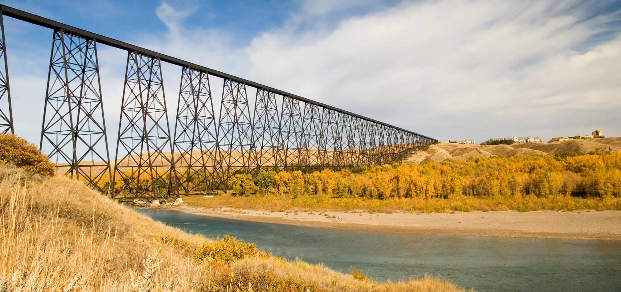
-
Article
Music in Lethbridge
Alberta's third largest city, settled about 1870 and incorporated as a town in 1891 and as a city in 1906. It was named after William Lethbridge (1824-1901), first president of North Western Coal and Navigation Co.
"https://development.thecanadianencyclopedia.ca/images/tce_placeholder.jpg?v=e9dca980c9bdb3aa11e832e7ea94f5d9" // resources/views/front/categories/view.blade.php
https://development.thecanadianencyclopedia.ca/images/tce_placeholder.jpg?v=e9dca980c9bdb3aa11e832e7ea94f5d9
-
Article
Lévis
Lévis, Quebec, city incorporated in 2002, population 143,414 (2016 census), 138,769 (2011 census). Lévis covers an area of 444 km2. The city is located on the rocky cliffs opposite Quebec City, to which it is linked by ferry. Present-day Lévis is the result of multiple mergers. In 1989, it merged with the industrial city of Lauzon (inc 1957). The following year, Lévis combined with the town of Saint-David-de-l'Auberivière. In 2002, Lévis took in the cities of Charny, Saint-Jean-Chrysostome, Saint-Nicolas, Saint-Rédempteur and Saint-Romuald. The parishes of Saint-Joseph-de-la-Pointe-de-Lévy and Sainte-Hélène-de-Breakeyville were also included in the fusion. The municipalities of Pintendre, Saint-Étienne-de-Lauzon, Desjardins and Chutes-de-la-Chaudière were also merged in.
"https://d2ttikhf7xbzbs.cloudfront.net/media/media/1024px-Ville_de_Lévis01.jpg" // resources/views/front/categories/view.blade.php
https://d2ttikhf7xbzbs.cloudfront.net/media/media/1024px-Ville_de_Lévis01.jpg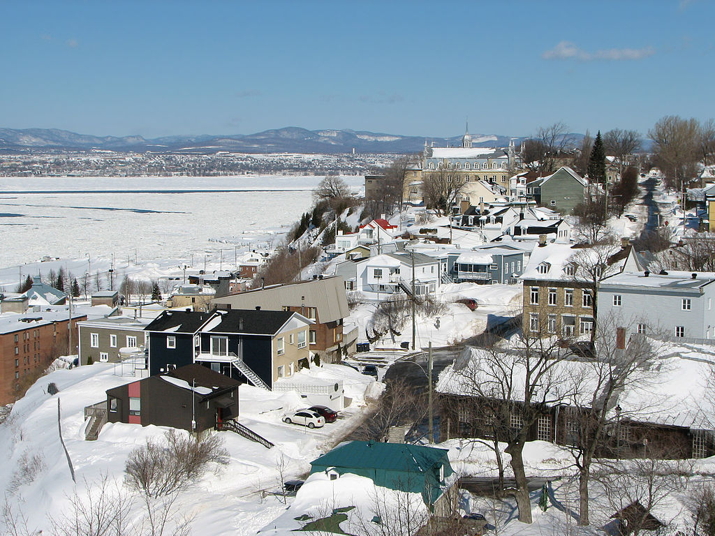
-
Article
Lewisporte
Lewisporte, NL, incorporated as a town in 1946, population 3483 (2011c), 3308 (2006c). The Town of Lewisporte is a deep-water port and shipping centre in Notre Dame Bay, north-central Newfoundland.
"https://development.thecanadianencyclopedia.ca/images/tce_placeholder.jpg?v=e9dca980c9bdb3aa11e832e7ea94f5d9" // resources/views/front/categories/view.blade.php
https://development.thecanadianencyclopedia.ca/images/tce_placeholder.jpg?v=e9dca980c9bdb3aa11e832e7ea94f5d9
-
Article
Liard Highway
Liard Highway is an all-weather road linking northern British Columbia and the Northwest Territories. Beginning 27 km north of Fort Nelson on the Alaska Highway, it runs 400 km north to join the Mackenzie Highway a short distance south of Fort Simpson, NWT.
"https://development.thecanadianencyclopedia.ca/images/tce_placeholder.jpg?v=e9dca980c9bdb3aa11e832e7ea94f5d9" // resources/views/front/categories/view.blade.php
https://development.thecanadianencyclopedia.ca/images/tce_placeholder.jpg?v=e9dca980c9bdb3aa11e832e7ea94f5d9
-
Article
Liard River
The Liard River is 1,115 km long and is a major tributary to the Mackenzie River.
"https://d2ttikhf7xbzbs.cloudfront.net/media/media/d8c9eefb-7ec2-49a9-afc5-1b3766fa968f.jpg" // resources/views/front/categories/view.blade.php
https://d2ttikhf7xbzbs.cloudfront.net/media/media/d8c9eefb-7ec2-49a9-afc5-1b3766fa968f.jpg