Browse "Places"
-
Article
Metlakatla Pass Area
Metlakatla Pass, or Venn Passage, is located 4 km west of Prince Rupert on the northern BC coast.
"https://development.thecanadianencyclopedia.ca/images/tce_placeholder.jpg?v=e9dca980c9bdb3aa11e832e7ea94f5d9" // resources/views/front/categories/view.blade.php
https://development.thecanadianencyclopedia.ca/images/tce_placeholder.jpg?v=e9dca980c9bdb3aa11e832e7ea94f5d9
-
Article
Mica Bay Incident
In November 1849, a force of Anishinaabeg (see Ojibwe) and Métis warriors, led by Chiefs Oshawano, Shingwaukonse and Nebenaigoching, forced the Quebec and Lake Superior Mining Association to stop operating at Pointe aux Mines, Mica Bay, Lake Superior. Mica Bay is approximately 100 km northwest of Sault Ste. Marie (by road) on Lake Superior. The closure of the mine and the reaction of the Canada West authorities are known as the Mica Bay Incident.
"https://d2ttikhf7xbzbs.cloudfront.net/media/new_article_images/MicaBayIncident/Mica_Bay_c1850.jpg" // resources/views/front/categories/view.blade.php
https://d2ttikhf7xbzbs.cloudfront.net/media/new_article_images/MicaBayIncident/Mica_Bay_c1850.jpg
-
Article
Middleton
Middleton, NS, incorporated as a town in 1909, population 1749 (2011c), 1829 (2006c). The Town of Middleton is located in Nova Scotia's historic ANNAPOLIS VALLEY.
"https://d2ttikhf7xbzbs.cloudfront.net/media/media/bcfd90ed-d214-45b6-8e09-5896fdf32004.jpg" // resources/views/front/categories/view.blade.php
https://d2ttikhf7xbzbs.cloudfront.net/media/media/bcfd90ed-d214-45b6-8e09-5896fdf32004.jpg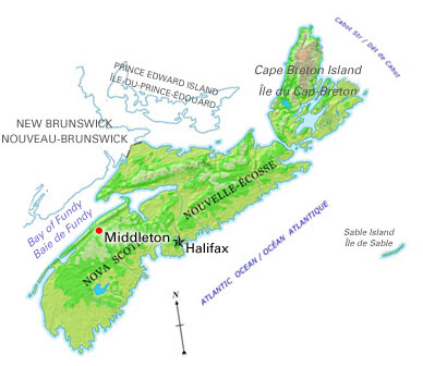
-
Article
Midland
Midland, Ont, incorporated as a town in 1890, population 16 572 (2011c), 16 330 (2006c). The Town of Midland is located on Midland Bay, an inlet of Georgian Bay. It is about 145 km by road north of Toronto.
"https://d2ttikhf7xbzbs.cloudfront.net/media/media/16b8b94b-0ca0-468a-8f8f-09141c3462be.jpg" // resources/views/front/categories/view.blade.php
https://d2ttikhf7xbzbs.cloudfront.net/media/media/16b8b94b-0ca0-468a-8f8f-09141c3462be.jpg
-
Article
Milk River
WRITING-ON-STONE PROVINCIAL PARK and a natural area in Alberta protect parts of the river's remarkable landscapes. The American explorers Meriwether Lewis and William Clark gave the Milk River its name (in 1805) because its colour reminded them of a cup of tea mixed with milk.
"https://d2ttikhf7xbzbs.cloudfront.net/media/media/ae2dfa9d-3fd2-48ea-b69e-74d80a659e8b.jpg" // resources/views/front/categories/view.blade.php
https://d2ttikhf7xbzbs.cloudfront.net/media/media/ae2dfa9d-3fd2-48ea-b69e-74d80a659e8b.jpg
-
Article
Milton
Milton, Ontario, incorporated as a town in 1857, population 132,979 (2021 census), 110,128 (2016 census). One of four municipalities in Halton Region, Milton’s odd shape means it shares a border with six communities. Milton’s modern borders were created in 1974, from Nassagaweya Township, the Town of Milton, and parts of Esquesing, Trafalgar, and Nelson townships. Throughout history, the Milton area has been home to different Indigenous groups, namely the Neutral, Huron-Wendat, Haudenosaunee and Anishinaabeg, including the Mississauga. The land is within treaties 3 ¾, 14, and 19 (see Upper Canada Land Surrenders).
"https://d2ttikhf7xbzbs.cloudfront.net/media/new_article_images/Milton/MiltonDowntown.jpg" // resources/views/front/categories/view.blade.php
https://d2ttikhf7xbzbs.cloudfront.net/media/new_article_images/Milton/MiltonDowntown.jpg
-
Article
Minas Basin
Minas Basin is the broadest part of the south-eastern head of the Bay of FUNDY and lies entirely within Nova Scotia. It merges westward into Fundy, through Minas Channel, 5 km wide, and eastward into Cobequid Bay, and is widest (30 km) south of Parrsboro, Nova Scotia.
"https://d2ttikhf7xbzbs.cloudfront.net/media/media/be636a29-f69f-4cdf-b060-f5c1dba7c65e.jpg" // resources/views/front/categories/view.blade.php
https://d2ttikhf7xbzbs.cloudfront.net/media/media/be636a29-f69f-4cdf-b060-f5c1dba7c65e.jpg
-
Article
Minnedosa
Minnedosa, Man, Manitoba, incorporated as a town in 1883, population 2587 (2011c), 2474 (2006c). The Town of Minnedosa is located 205 km northwest of Winnipeg, on the east side of the Little Saskatchewan River.
"https://development.thecanadianencyclopedia.ca/images/tce_placeholder.jpg?v=e9dca980c9bdb3aa11e832e7ea94f5d9" // resources/views/front/categories/view.blade.php
https://development.thecanadianencyclopedia.ca/images/tce_placeholder.jpg?v=e9dca980c9bdb3aa11e832e7ea94f5d9
-
Article
Minto
Minto, NB, incorporated as a village in1962, population 2505 (2011c), 2681 (2006c). It is located 56 km north of Fredericton in the Minto coalfields.
"https://development.thecanadianencyclopedia.ca/images/tce_placeholder.jpg?v=e9dca980c9bdb3aa11e832e7ea94f5d9" // resources/views/front/categories/view.blade.php
https://development.thecanadianencyclopedia.ca/images/tce_placeholder.jpg?v=e9dca980c9bdb3aa11e832e7ea94f5d9
-
Article
Mirabel
Mirabel, Quebec, incorporated as a city in 1971, population 50,513 (2016 census), 41,957 (2011 census). Mirabel is located some 57 km northwest of Montreal, is one of Quebec's youngest cities and also one of its most extended. It is home to the former Montreal-Mirabel International Airport. Mirabel is situated on the ancestral lands of the Haudenosaunee, including the Kanyen'kehà:ka, as well as the Anishinaabeg, notably the Algonquin (see Indigenous peoples in Canada).
"https://development.thecanadianencyclopedia.ca/images/tce_placeholder.jpg?v=e9dca980c9bdb3aa11e832e7ea94f5d9" // resources/views/front/categories/view.blade.php
https://development.thecanadianencyclopedia.ca/images/tce_placeholder.jpg?v=e9dca980c9bdb3aa11e832e7ea94f5d9
-
Article
Miramichi
Miramichi, New Brunswick, incorporated as a city in 1995, population 17,692 (2021 census), 17,537 (2016 census). The City of Miramichi is in northeastern New Brunswick at the mouth of the Miramichi River, one of Canada's most famous salmon rivers.
"https://d2ttikhf7xbzbs.cloudfront.net/media/media/177eafa5-be90-43c9-879c-7a35bbb3333f.jpg" // resources/views/front/categories/view.blade.php
https://d2ttikhf7xbzbs.cloudfront.net/media/media/177eafa5-be90-43c9-879c-7a35bbb3333f.jpg
-
Article
Miramichi River
The Miramichi River is 217 km long from its source in Juniper, in central New Brunswick, to the Gulf of St. Lawrence.
"https://d2ttikhf7xbzbs.cloudfront.net/media/media/169334dd-4829-4936-a09b-b91e809c65ef.jpg" // resources/views/front/categories/view.blade.php
https://d2ttikhf7xbzbs.cloudfront.net/media/media/169334dd-4829-4936-a09b-b91e809c65ef.jpg
-
Article
Miscou Island
Miscou Island, 64 km2, comprises the most eastern part of Gloucester County, New Brunswick, on the west side of the Gulf of St Lawrence and at the entrance to CHALEUR BAY.
"https://development.thecanadianencyclopedia.ca/images/tce_placeholder.jpg?v=e9dca980c9bdb3aa11e832e7ea94f5d9" // resources/views/front/categories/view.blade.php
https://development.thecanadianencyclopedia.ca/images/tce_placeholder.jpg?v=e9dca980c9bdb3aa11e832e7ea94f5d9
-
Article
Mission
Mission, BC, incorporated as a district municipality in 1969, population 36 426 (2011c), 34 505 (2006c). The District of Mission is located on the north bank ofthe FRASER RIVER, 70 km by road east of VANCOUVER.
"https://d2ttikhf7xbzbs.cloudfront.net/media/media/6232f070-823a-44e3-8285-5bb9d14cf197.jpg" // resources/views/front/categories/view.blade.php
https://d2ttikhf7xbzbs.cloudfront.net/media/media/6232f070-823a-44e3-8285-5bb9d14cf197.jpg
-
Article
Mississauga
Mississauga, Ontario, incorporated as a city in 1974, population 717,961 (2021 census), 721,599 (2016 census). The city was created by the amalgamation of the Town of Mississauga and the Towns of Port Credit and Streetsville. Located west of Toronto, Mississauga is part of the Regional Municipality of Peel. It is located within the Credit and Humber river watersheds. Throughout history, the Mississauga area has been home to different Indigenous groups, namely the Huron-Wendat, Haudenosaunee and Anishinaabeg, including the Mississauga. The land is covered by treaties 14, 19, 22 and 23.
"https://d2ttikhf7xbzbs.cloudfront.net/media/new_article_images/Mississauga/SquareOne.jpg" // resources/views/front/categories/view.blade.php
https://d2ttikhf7xbzbs.cloudfront.net/media/new_article_images/Mississauga/SquareOne.jpg