Browse "Things"
-
Article
Fort Frontenac
Frontenac reoccupied the site, rebuilding the fort in 1695, and the post became known as Fort Frontenac. Reinforced by troops under François-Charles de Bourlamaque and later the Marquis de MONTCALM, it nevertheless fell to the British under John Bradstreet in August 1758.
"https://d2ttikhf7xbzbs.cloudfront.net/media/media/224b2211-a1a9-4b89-888f-fab9972af144.jpg" // resources/views/front/categories/view.blade.php
https://d2ttikhf7xbzbs.cloudfront.net/media/media/224b2211-a1a9-4b89-888f-fab9972af144.jpg
-
Article
Fort Haldimand
Fort Haldimand, located on the west promontory of Carleton Island at the east end of Lake Ontario, about 16 km offshore from Kingston, Ontario, was built by the British in 1778 during the American Revolution.
"https://development.thecanadianencyclopedia.ca/images/tce_placeholder.jpg?v=e9dca980c9bdb3aa11e832e7ea94f5d9" // resources/views/front/categories/view.blade.php
https://development.thecanadianencyclopedia.ca/images/tce_placeholder.jpg?v=e9dca980c9bdb3aa11e832e7ea94f5d9
-
Article
Fort Henry
Fort Henry, KINGSTON, Ont, was originally built during the WAR OF 1812 on Point Henry, beside Lake Ontario, to guard the outlet to the St Lawrence River and the Kingston Navy Yards.
"https://d2ttikhf7xbzbs.cloudfront.net/media/media/c4427c9c-96dd-4f5c-bb92-6c22ac423cb3.jpg" // resources/views/front/categories/view.blade.php
https://d2ttikhf7xbzbs.cloudfront.net/media/media/c4427c9c-96dd-4f5c-bb92-6c22ac423cb3.jpg
-
Article
Fort la Reine
Fort la Reine is the name used for a series of early French fur-trade posts located west of Winnipeg on the Assiniboine River. The original fort was established in 1738 by Pierre Gaultier de Varennes et de La Vérendrye and his sons, independent fur traders and explorers.
"https://development.thecanadianencyclopedia.ca/images/tce_placeholder.jpg?v=e9dca980c9bdb3aa11e832e7ea94f5d9" // resources/views/front/categories/view.blade.php
https://development.thecanadianencyclopedia.ca/images/tce_placeholder.jpg?v=e9dca980c9bdb3aa11e832e7ea94f5d9
-
Article
Fort Michilimackinac
Fort Michilimackinac is located on the south side of the Straits of Mackinac. It sits on a sand beach in the northernmost extension of the Lower Peninsula of Michigan. Michilimackinac was the second fort to guard the Straits of Mackinac. The fort was a key trade, military, and diplomatic post for the French (1715–61) and the British (1761–81). The fort’s buildings were moved by the British in 1780-1 to a more defensible location on Mackinac Island. Fort Michilimackinac was reconstructed in the 20th century and serves as a living history museum in Michigan.
"https://d2ttikhf7xbzbs.cloudfront.net/Michilimackinac/Michilimackinac-State-Park-buildings.jpg" // resources/views/front/categories/view.blade.php
https://d2ttikhf7xbzbs.cloudfront.net/Michilimackinac/Michilimackinac-State-Park-buildings.jpg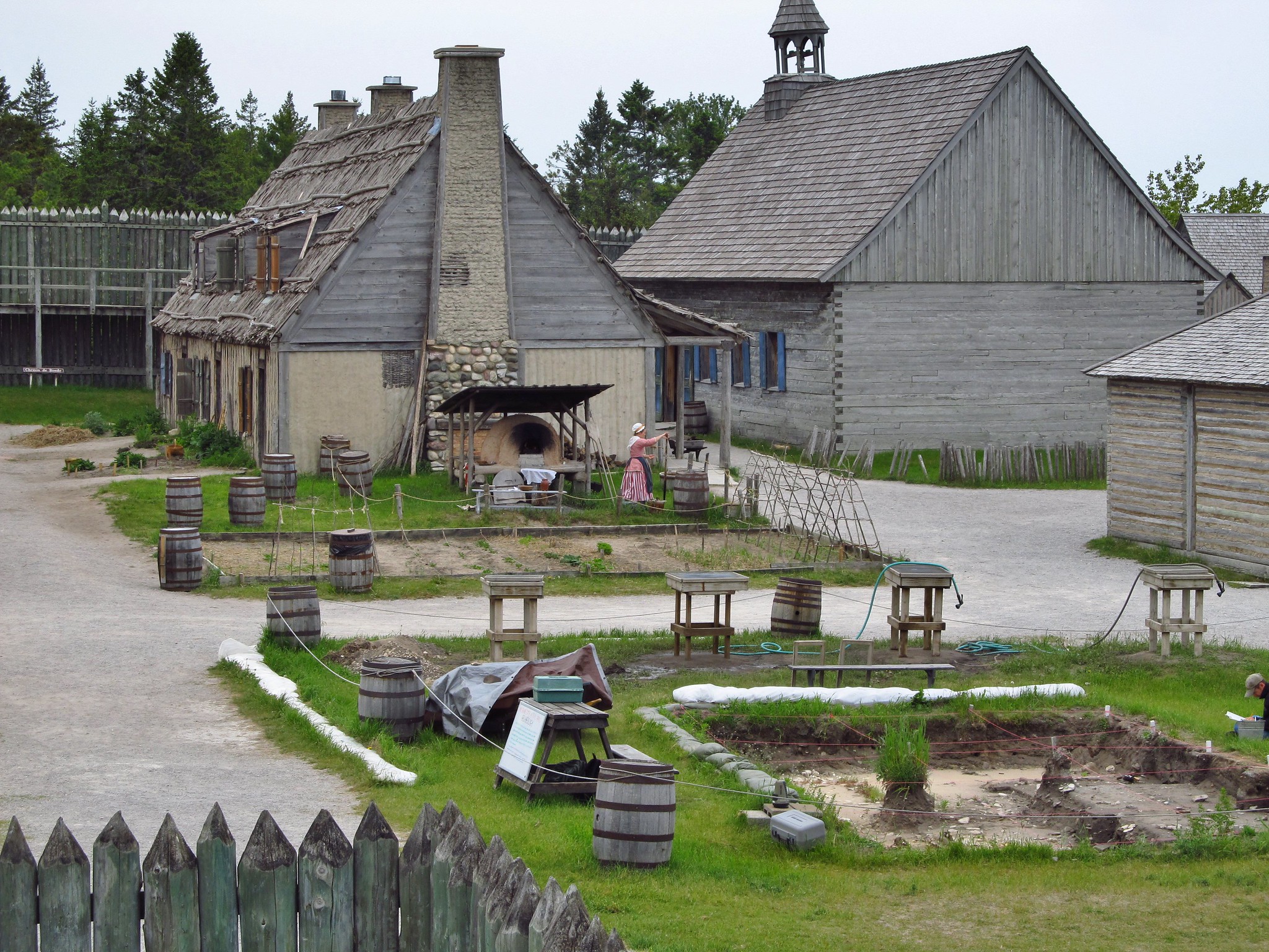
-
Article
Fort Niagara
Throughout the American Revolution, Fort Niagara was the major British supply depot for the Loyalist provincial troops, Butler's Rangers, and Seneca allies who raided rebel supply lines.
"https://d2ttikhf7xbzbs.cloudfront.net/media/media/659c26df-741b-477d-8d28-b5a7c4212206.jpg" // resources/views/front/categories/view.blade.php
https://d2ttikhf7xbzbs.cloudfront.net/media/media/659c26df-741b-477d-8d28-b5a7c4212206.jpg
-
Article
Fort Reliance
Fort Reliance, YT, is an abandoned post, established in 1874, located on the east bank of the YUKON RIVER, 13 km downstream from DAWSON. It remained the centre of the FUR TRADE and mining on the upper Yukon River for more than a decade.
"https://development.thecanadianencyclopedia.ca/images/tce_placeholder.jpg?v=e9dca980c9bdb3aa11e832e7ea94f5d9" // resources/views/front/categories/view.blade.php
https://development.thecanadianencyclopedia.ca/images/tce_placeholder.jpg?v=e9dca980c9bdb3aa11e832e7ea94f5d9
-
Article
Fort Saint-Pierre
Fort Saint-Pierre is a French trading post spanning the years c. 1632 to 1669. It is situated on the southeastern shore of Cape Breton Island, in the village of St. Peters, on the Atlantic coast of a narrow isthmus separating the inland waterway of Lake Bras D'or from the open ocean.
"https://d2ttikhf7xbzbs.cloudfront.net/media/media/53e44654-9a96-4878-852f-9637b47db180.jpg" // resources/views/front/categories/view.blade.php
https://d2ttikhf7xbzbs.cloudfront.net/media/media/53e44654-9a96-4878-852f-9637b47db180.jpg
-
Article
Fort Selkirk
The trading post was short-lived; it shut down in the summer of its establishment after it was attacked and plundered by the Chilkat. In 1898-99 the site was the base of the YUKON FIELD FORCE. A private trading post was established by Arthur Harper around 1890.
"https://d2ttikhf7xbzbs.cloudfront.net/media/media/ed5cd90d-59e6-4f79-98c0-9d447f907a0b.jpg" // resources/views/front/categories/view.blade.php
https://d2ttikhf7xbzbs.cloudfront.net/media/media/ed5cd90d-59e6-4f79-98c0-9d447f907a0b.jpg
-
Article
Fort Carillon (Ticonderoga)
Fort Carillon was built in 1755 on the orders of the governor of New France, Pierre de Rigaud de Vaudreuil. Situated at the junction of Lake George and Lake Champlain, the fort was intended to reinforce France's military presence in an area contested by the British colonies. In 1759, Fort Carillon was abandoned by the French and renamed Fort Ticonderoga by the British. (See Seven Years’ War.)
"https://d2ttikhf7xbzbs.cloudfront.net/Fort_Ticonderoga_Ticonderoga_NY.jpg" // resources/views/front/categories/view.blade.php
https://d2ttikhf7xbzbs.cloudfront.net/Fort_Ticonderoga_Ticonderoga_NY.jpg
-
Article
Fort Vancouver
Fort Vancouver, a HUDSON'S BAY CO fur-trade post, was originally constructed in 1825 by Dr. John McLoughlin about 150 km inland on the north bank of the Columbia River, 8 km above the mouth of the Willamette. In 1829, the
"https://d2ttikhf7xbzbs.cloudfront.net/media/media/8995b1e1-60ec-48e0-8b23-d944da85cc4d.jpg" // resources/views/front/categories/view.blade.php
https://d2ttikhf7xbzbs.cloudfront.net/media/media/8995b1e1-60ec-48e0-8b23-d944da85cc4d.jpg
-
Article
Fort William
Named in 1807 after NWC chief superintendent William MCGILLIVRAY, Fort William occupied a pivotal place in the company's vast trading network. In 1816-17 Lord SELKIRK occupied Fort William for 10 months as a consequence of the SEVEN OAKS INCIDENT.
"https://d2ttikhf7xbzbs.cloudfront.net/media/media/7b13aa86-dd8f-4056-b650-3839e00b77e9.jpg" // resources/views/front/categories/view.blade.php
https://d2ttikhf7xbzbs.cloudfront.net/media/media/7b13aa86-dd8f-4056-b650-3839e00b77e9.jpg
-
Article
Fortification
Although the barrier posed by these walls was sometimes increased by setting a ditch below their outer faces, fortification did not progress beyond this rather simple conception until the 16th century.
"https://d2ttikhf7xbzbs.cloudfront.net/media/media/528fc0db-255d-4206-bfde-3fcb0b932747.jpg" // resources/views/front/categories/view.blade.php
https://d2ttikhf7xbzbs.cloudfront.net/media/media/528fc0db-255d-4206-bfde-3fcb0b932747.jpg
-
Article
Forty-ninth Parallel
The forty-ninth parallel is the line of latitude that forms the boundary between Canada and the US from Lake of the Woods to the Strait of Georgia.
"https://d2ttikhf7xbzbs.cloudfront.net/media/media/ab134ae7-ce92-4a7d-8509-11a50d91c57b.jpg" // resources/views/front/categories/view.blade.php
https://d2ttikhf7xbzbs.cloudfront.net/media/media/ab134ae7-ce92-4a7d-8509-11a50d91c57b.jpg
-
Editorial
History of the Canada-US Border in the West
The following article is an editorial written by The Canadian Encyclopedia staff. Editorials are not usually updated. In December 2001, U.S. Attorney-General John Ashcroft announced plans to deploy military personnel to patrol the Canada-U.S. border. After September 11, Ashcroft criticized Canada's porous border, though there was no evidence that any of the terrorists, all holding legal U.S. visas, came through Canada. It was not the first time that the longest undefended, and perhaps indefensible, border in the world was contentious.
"https://development.thecanadianencyclopedia.ca/images/tce_placeholder.jpg?v=e9dca980c9bdb3aa11e832e7ea94f5d9" // resources/views/front/categories/view.blade.php
https://development.thecanadianencyclopedia.ca/images/tce_placeholder.jpg?v=e9dca980c9bdb3aa11e832e7ea94f5d9