Browse "Cities & Populated Places"
-
Article
Grand-Mère
The first French missionary contact with the indigenous people, the MONTAGNAIS, took place in 1651, but the region remained virtually unsettled for nearly 200 years.
"https://development.thecanadianencyclopedia.ca/images/tce_placeholder.jpg?v=e9dca980c9bdb3aa11e832e7ea94f5d9" // resources/views/front/categories/view.blade.php
https://development.thecanadianencyclopedia.ca/images/tce_placeholder.jpg?v=e9dca980c9bdb3aa11e832e7ea94f5d9
-
Article
Grande Cache
Grande Cache, Alta, incorporated as a town in 1983, population 4319 (2011c), 3783 (2006c). The Town of Grande Cache is located 430 km northwest of Edmonton, on a mountain plateau near the confluence of the Smoky and Sulphur rivers.
"https://development.thecanadianencyclopedia.ca/images/tce_placeholder.jpg?v=e9dca980c9bdb3aa11e832e7ea94f5d9" // resources/views/front/categories/view.blade.php
https://development.thecanadianencyclopedia.ca/images/tce_placeholder.jpg?v=e9dca980c9bdb3aa11e832e7ea94f5d9
-
Article
Grande-Île
This rural municipality has become a residential suburb of Valleyfield and of Greater Montréal. Its population nearly doubled from 1981 to 1996. Even though manufacturing and construction industries play a major role in the local economy, agriculture is still prominent.
"https://d2ttikhf7xbzbs.cloudfront.net/media/media/a9d99302-7475-4efc-9f79-322316675713.jpg" // resources/views/front/categories/view.blade.php
https://d2ttikhf7xbzbs.cloudfront.net/media/media/a9d99302-7475-4efc-9f79-322316675713.jpg
-
Article
Grande Prairie
Grande Prairie, Alberta, incorporated as a city in 1958, population 64,141 (2021 census), 63,166 (2016 census). The city of Grande Prairie is located 456 km northwest of Edmonton and takes its name from the large prairie that lies to the east, north and west of it. The city is the business and transportation centre of Alberta’s Peace River region.
"https://d2ttikhf7xbzbs.cloudfront.net/media/media/582cc550-9a41-4bcd-8d97-f114a358b312.jpg" // resources/views/front/categories/view.blade.php
https://d2ttikhf7xbzbs.cloudfront.net/media/media/582cc550-9a41-4bcd-8d97-f114a358b312.jpg
-
Article
Grandview
Grandview, Manitoba, incorporated as a village in 1906 and as a town in 1909, population 859 (2011c), 839 (2006c). The Town of Grandview nestles between Riding and Duck mountains on the Valley River, 360 km northwest of Winnipeg.
"https://development.thecanadianencyclopedia.ca/images/tce_placeholder.jpg?v=e9dca980c9bdb3aa11e832e7ea94f5d9" // resources/views/front/categories/view.blade.php
https://development.thecanadianencyclopedia.ca/images/tce_placeholder.jpg?v=e9dca980c9bdb3aa11e832e7ea94f5d9
-
Article
Granisle
Granisle, BC, incorporated as a village in 1971, population 303 (2011c), 364 (2006c). The Village of Granisle is located in central British Columbia on the west shore of Babine Lake, the longest natural lake in the province (at 177 km).
"https://development.thecanadianencyclopedia.ca/images/tce_placeholder.jpg?v=e9dca980c9bdb3aa11e832e7ea94f5d9" // resources/views/front/categories/view.blade.php
https://development.thecanadianencyclopedia.ca/images/tce_placeholder.jpg?v=e9dca980c9bdb3aa11e832e7ea94f5d9
-
Article
Gravelbourg
In 1918 a convent was built in the town as well as a college, which was affiliated with UNIVERSITY OF OTTAWA; other Catholic buildings followed: a Romanesque cathedral (1919), a monastery (1926) and a hospital.
"https://development.thecanadianencyclopedia.ca/images/tce_placeholder.jpg?v=e9dca980c9bdb3aa11e832e7ea94f5d9" // resources/views/front/categories/view.blade.php
https://development.thecanadianencyclopedia.ca/images/tce_placeholder.jpg?v=e9dca980c9bdb3aa11e832e7ea94f5d9
-
Article
Gravenhurst
Gravenhurst, Ontario, incorporated as a town in 1887, population 13,157 (2021 census), 12,311 (2016 census). The Town of Gravenhurst is located at the south end of Lake Muskoka, 170 km north of Toronto. The name of Gravenhurst was inspired by the book “Gravenhurst: Or Thoughts on Good & Evil.”
"https://d2ttikhf7xbzbs.cloudfront.net/gravenhurst/Town-Hall-and-Public-Library-Gravenhurst.jpg" // resources/views/front/categories/view.blade.php
https://d2ttikhf7xbzbs.cloudfront.net/gravenhurst/Town-Hall-and-Public-Library-Gravenhurst.jpg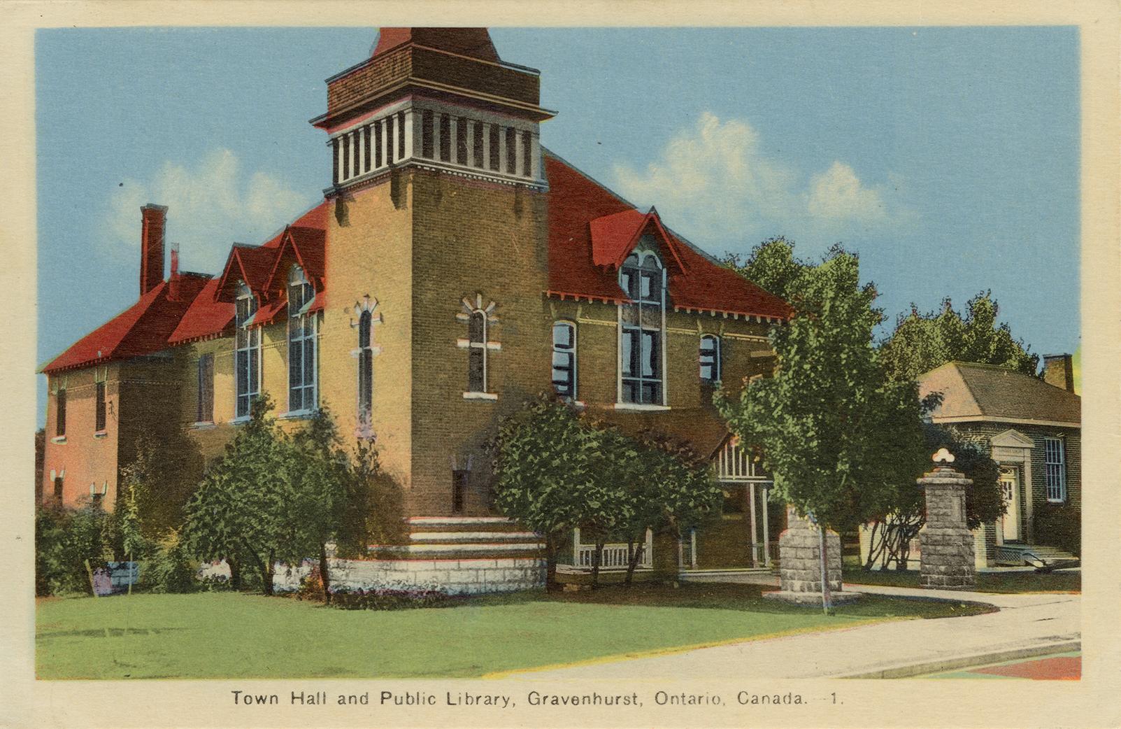
-
Article
Greater Napanee
Greater Napanee, Ont, incorporated as a town in 1864, population 15 511 (2011c), 15 400 (2006c). The Town of Greater Napanee is located 39 km west of Kingston on the Napanee River and six km from the Bay of Quinte on Lake Ontario.
"https://d2ttikhf7xbzbs.cloudfront.net/media/media/53717f9c-a23e-4602-aeb5-9cfdb8f04b79.jpg" // resources/views/front/categories/view.blade.php
https://d2ttikhf7xbzbs.cloudfront.net/media/media/53717f9c-a23e-4602-aeb5-9cfdb8f04b79.jpg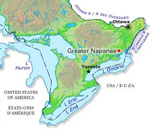
-
Article
Greenfield Park
Greenfield Park, Qué, pop 16 978 (2001c), 17 337 (1996c), incorporated as a city in 1911, from January 2002, is a borough of the new city of Longueuil created by the amalgamation of 8 distinct municipalities. Greenfield Park is located opposite Île de Montréal on the South Shore of the St Lawrence River.
"https://d2ttikhf7xbzbs.cloudfront.net/media/media/066c39bd-0c7c-422e-b8db-dabafc5f4043.jpg" // resources/views/front/categories/view.blade.php
https://d2ttikhf7xbzbs.cloudfront.net/media/media/066c39bd-0c7c-422e-b8db-dabafc5f4043.jpg
-
Article
Greenwood
Greenwood, BC, incorporated as a city in 1897, population 708 (2011c), 625 (2006c). The City of Greenwood is located 27 km west of GRAND FORKS on Highway 3. It grew as a result of the mining boom in the Boundary District in the 1890s and nearly died when the boom ended.
"https://d2ttikhf7xbzbs.cloudfront.net/media/media/e9c8f32a-e1a5-4721-8e46-8f3903b9c210.jpg" // resources/views/front/categories/view.blade.php
https://d2ttikhf7xbzbs.cloudfront.net/media/media/e9c8f32a-e1a5-4721-8e46-8f3903b9c210.jpg
-
Article
Griffintown
Griffintown was developed in the 19th century as a working-class Irish neighbourhood of Montréal. It underwent several attempts at urban revitalization from the 1980s onwards. Since 2010, there have been a number of controversial real estate developments in the neighbourhood. The neighbourhood is part of the Sud-Ouest and Ville-Marie boroughs of Montréal. It is located along the Lachine Canal, between Notre-Dame, McGill and Guy streets.
"https://d2ttikhf7xbzbs.cloudfront.net/View-2942.jpg" // resources/views/front/categories/view.blade.php
https://d2ttikhf7xbzbs.cloudfront.net/View-2942.jpg
-
Article
Grimsby
Grimsby, Ontario, incorporated as a town in 1970, population 25 325 (2011c), 23 937 (2006c). The Town of Grimsby is situated on the NIAGARA PENINSULA to the east of Hamilton.
"https://development.thecanadianencyclopedia.ca/images/tce_placeholder.jpg?v=e9dca980c9bdb3aa11e832e7ea94f5d9" // resources/views/front/categories/view.blade.php
https://development.thecanadianencyclopedia.ca/images/tce_placeholder.jpg?v=e9dca980c9bdb3aa11e832e7ea94f5d9
-
Article
Grimshaw
Grimshaw, Alta, incorporated as a town in 1953, population 2515 (2011c), 2537 (2006c). The Town of Grimshaw is located in the Peace River area 26 km west of the town of PEACE RIVER.
"https://d2ttikhf7xbzbs.cloudfront.net/media/media/2862aeaf-cace-4b85-aac6-6d4f4ad9c96e.jpg" // resources/views/front/categories/view.blade.php
https://d2ttikhf7xbzbs.cloudfront.net/media/media/2862aeaf-cace-4b85-aac6-6d4f4ad9c96e.jpg
-
Article
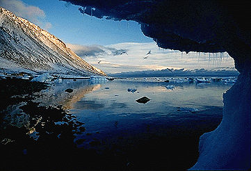
Grise Fiord
Grise Fiord, Nunavut, incorporated as a hamlet in 1987, population 130 (2011c), 141 (2006c). The Hamlet of Grise Fiord is located on the south coast of ELLESMERE ISLAND.
"https://d2ttikhf7xbzbs.cloudfront.net/media/media/81bcc22e-e2e4-4910-bb40-41c34dc9ce59.jpg" // resources/views/front/categories/view.blade.php
https://d2ttikhf7xbzbs.cloudfront.net/media/media/81bcc22e-e2e4-4910-bb40-41c34dc9ce59.jpg