Browse "Cities & Populated Places"
-
Article
Moosonee
Moosonee, Ont, incorporated as a town in 2001, population 1725 (2011c), 2006 (2006c). The Town of Moosonee is located on the Moose River, 25 km from James Bay.
"https://development.thecanadianencyclopedia.ca/images/tce_placeholder.jpg?v=e9dca980c9bdb3aa11e832e7ea94f5d9" // resources/views/front/categories/view.blade.php
https://development.thecanadianencyclopedia.ca/images/tce_placeholder.jpg?v=e9dca980c9bdb3aa11e832e7ea94f5d9
-
Article
Morden
Morden, Manitoba, incorporated as a city in 2012, population 9,929 (2021 census), 8,668 (2016 census). The Town of Morden is located 104 km southwest of Winnipeg and 20 km north of the international boundary with the U.S. Morden is situated in Treaties No. 1 Territory and on the traditional lands of the Anishinaabe, Cree, Oji-Cree, and Dakota Nations. The Métis Nation, notably the Red River Métis, have a historical and ongoing presence on this land.
"https://development.thecanadianencyclopedia.ca/images/tce_placeholder.jpg?v=e9dca980c9bdb3aa11e832e7ea94f5d9" // resources/views/front/categories/view.blade.php
https://development.thecanadianencyclopedia.ca/images/tce_placeholder.jpg?v=e9dca980c9bdb3aa11e832e7ea94f5d9
-
Article
Morinville
Morinville, Alta, incorporated as a village in 1901 and as a town in 1911, population 8569 (2011c), 6775 (2006c). The Town of Morinville is located on the Canadian National Railway main line, 41 km northwest of Edmonton.
"https://development.thecanadianencyclopedia.ca/images/tce_placeholder.jpg?v=e9dca980c9bdb3aa11e832e7ea94f5d9" // resources/views/front/categories/view.blade.php
https://development.thecanadianencyclopedia.ca/images/tce_placeholder.jpg?v=e9dca980c9bdb3aa11e832e7ea94f5d9
-
Article
Morris
Morris, Manitoba, incorporated as a town in 1883, population 1797 (2011c), 1643 (2006c). The Town of Morris is located at the confluence of the Red and Morris rivers, 55 km south of Winnipeg.
"https://development.thecanadianencyclopedia.ca/images/tce_placeholder.jpg?v=e9dca980c9bdb3aa11e832e7ea94f5d9" // resources/views/front/categories/view.blade.php
https://development.thecanadianencyclopedia.ca/images/tce_placeholder.jpg?v=e9dca980c9bdb3aa11e832e7ea94f5d9
-
Article
Mount Pearl
Mount Pearl, NL, incorporated as a city in 1988, population 24 284 (2011c), 24 671 (2006c). The City of Mount Pearl, the province's second-largest city, is situated just southwest of St John's.
"https://development.thecanadianencyclopedia.ca/images/tce_placeholder.jpg?v=e9dca980c9bdb3aa11e832e7ea94f5d9" // resources/views/front/categories/view.blade.php
https://development.thecanadianencyclopedia.ca/images/tce_placeholder.jpg?v=e9dca980c9bdb3aa11e832e7ea94f5d9
-
Article
Musgrave Harbour
Musgrave Harbour, NL, incorporated as a town in 1954, population 1053 (2011c), 1085 (2006c). First incorporated as the Rural District Council of Musgrave Harbour and Doting Cove, the Town of Musgrave Harbour is located on the northeastern coast of Newfoundland at the mouth of Hamilton Sound, 100 km east of Gander.
"https://d2ttikhf7xbzbs.cloudfront.net/media/media/920c28cf-0b78-4316-a08e-1a18644cc47e.jpg" // resources/views/front/categories/view.blade.php
https://d2ttikhf7xbzbs.cloudfront.net/media/media/920c28cf-0b78-4316-a08e-1a18644cc47e.jpg
-
Article
Muskoka
District Municipality of Muskoka, Ontario, incorporated in 1971, permanent population 66,674 (2021 census), 60,614 (2016 census); estimated seasonal population 85,163 (2016). Muskoka is an iconic area of Ontario’s cottage country located approximately 200 km north of Toronto. A destination for seasonal residents and tourists who have been drawn by its natural beauty since the late 1800s, the district has equally been home to generations of permanent residents.
"https://d2ttikhf7xbzbs.cloudfront.net/media/media/b38374d2-1aa9-48ab-a86b-276b8da208de.jpg" // resources/views/front/categories/view.blade.php
https://d2ttikhf7xbzbs.cloudfront.net/media/media/b38374d2-1aa9-48ab-a86b-276b8da208de.jpg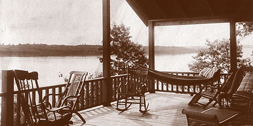
-
Article
Nahanni Butte
Nahanni Butte, NWT, Settlement, population 102 (2011c), 115 (2006c). The settlement of Nahanni Butte is located on the north side of the SOUTH NAHANNI RIVER near its junction with the LIARD RIVER, about 125 km north of the Northwest Territories and British Columbia border.
"https://development.thecanadianencyclopedia.ca/images/tce_placeholder.jpg?v=e9dca980c9bdb3aa11e832e7ea94f5d9" // resources/views/front/categories/view.blade.php
https://development.thecanadianencyclopedia.ca/images/tce_placeholder.jpg?v=e9dca980c9bdb3aa11e832e7ea94f5d9
-
Article
Nain
Nain, NL, incorporated as a town in 1970, population 1188 (2011c), 1034 (2006c). The Town of Nain is the most northerly community on the Labrador coast.
"https://development.thecanadianencyclopedia.ca/images/tce_placeholder.jpg?v=e9dca980c9bdb3aa11e832e7ea94f5d9" // resources/views/front/categories/view.blade.php
https://development.thecanadianencyclopedia.ca/images/tce_placeholder.jpg?v=e9dca980c9bdb3aa11e832e7ea94f5d9
-
Article
Nakusp
Nakusp, British Columbia, incorporated as a village in 1964, population 1,605 (2016 census), 1,569 (2011 census). The village of Nakusp is located on the east shore of Upper Arrow Lake at the foot of the Selkirk Mountains. It is in the West Kootenay district of south-eastern British Columbia. Nakusp is located on the traditional territory of the Sinixt, Ktunaxa, Secwepemc and Okanagan peoples. (See also Interior Salish.) The name is derived from a Sinixt word, though its meaning is debated. One interpretation is that the name Nakusp comes from a word meaning “the bay behind the long point,” another is that it means, “closed-in” or “safe.”
"https://development.thecanadianencyclopedia.ca/images/tce_placeholder.jpg?v=e9dca980c9bdb3aa11e832e7ea94f5d9" // resources/views/front/categories/view.blade.php
https://development.thecanadianencyclopedia.ca/images/tce_placeholder.jpg?v=e9dca980c9bdb3aa11e832e7ea94f5d9
-
Article
Nanaimo
Nanaimo, BC, incorporated as a city in 1874, population 83 810 (2011c), 78 692 (2006c).
"https://d2ttikhf7xbzbs.cloudfront.net/media/media/cabaef9d-ff42-41e5-bfd9-1ef1705f926c.jpg" // resources/views/front/categories/view.blade.php
https://d2ttikhf7xbzbs.cloudfront.net/media/media/cabaef9d-ff42-41e5-bfd9-1ef1705f926c.jpg
-
Article
Nanisivik
Nanisivik, Nunavut, is a settlement located on the south shore of Strathcona Sound on the Borden Peninsula of Baffin Island, 280 km northwest of Iqaluit.
"https://development.thecanadianencyclopedia.ca/images/tce_placeholder.jpg?v=e9dca980c9bdb3aa11e832e7ea94f5d9" // resources/views/front/categories/view.blade.php
https://development.thecanadianencyclopedia.ca/images/tce_placeholder.jpg?v=e9dca980c9bdb3aa11e832e7ea94f5d9
-
Article
Neepawa
Neepawa, Manitoba, incorporated as a town in 1883, population 3629 (2011c), 3298 (2006c). The Town of Neepawa on the fertile "Beautiful Plains," is 175 km west of Winnipeg.
"https://development.thecanadianencyclopedia.ca/images/tce_placeholder.jpg?v=e9dca980c9bdb3aa11e832e7ea94f5d9" // resources/views/front/categories/view.blade.php
https://development.thecanadianencyclopedia.ca/images/tce_placeholder.jpg?v=e9dca980c9bdb3aa11e832e7ea94f5d9
-
Article
Neguac
Neguac, NB, incorporated as a village in 1967, population 1678 (2011c), 1623 (2006c). The Village of Neguac is located in northeast New Brunswick near the head of Miramichi Bay, 41 km northeast of Miramichi.
"https://d2ttikhf7xbzbs.cloudfront.net/media/media/916d6c3d-9da2-4e33-bdc6-70bb07dfa1b5.jpg" // resources/views/front/categories/view.blade.php
https://d2ttikhf7xbzbs.cloudfront.net/media/media/916d6c3d-9da2-4e33-bdc6-70bb07dfa1b5.jpg
-
Article
Nelson
Nelson, BC, incorporated as a city in 1897, population 10 230 (2011c), 9258 (2006c). The City of Nelson, named after Hugh Nelson, lieutenant-governor of BC, overlooks the west arm of KOOTENAY LAKE. The prehistoric boundary of the INTERIOR SALISH and the KOOTENAY is nearby.
"https://development.thecanadianencyclopedia.ca/images/tce_placeholder.jpg?v=e9dca980c9bdb3aa11e832e7ea94f5d9" // resources/views/front/categories/view.blade.php
https://development.thecanadianencyclopedia.ca/images/tce_placeholder.jpg?v=e9dca980c9bdb3aa11e832e7ea94f5d9