Browse "Cities & Populated Places"
-
Article
Otterburn Park
The name Otterburn is a reminder of the birthplace of Sir Joseph Hickson, general manager of the GRAND TRUNK RAILWAY from 1874 to 1890.
"https://d2ttikhf7xbzbs.cloudfront.net/media/media/3343e517-5699-4e5b-8d48-17cc5952b771.jpg" // resources/views/front/categories/view.blade.php
https://d2ttikhf7xbzbs.cloudfront.net/media/media/3343e517-5699-4e5b-8d48-17cc5952b771.jpg
-
Article
Outlook
The town of Outlook developed as a result of railway land development. In 1908 the Canadian Pacific Railway purchased the farm of a local homesteader and announced that it would be developed as a townsite.
"https://development.thecanadianencyclopedia.ca/images/tce_placeholder.jpg?v=e9dca980c9bdb3aa11e832e7ea94f5d9" // resources/views/front/categories/view.blade.php
https://development.thecanadianencyclopedia.ca/images/tce_placeholder.jpg?v=e9dca980c9bdb3aa11e832e7ea94f5d9
-
Article
Outremont
Outremont, one of the smallest cities in terms of area of the MONTRÉAL Urban Community (MUC), is one of the most affluent, beautiful and picturesque residential communities on the island.
"https://development.thecanadianencyclopedia.ca/images/tce_placeholder.jpg?v=e9dca980c9bdb3aa11e832e7ea94f5d9" // resources/views/front/categories/view.blade.php
https://development.thecanadianencyclopedia.ca/images/tce_placeholder.jpg?v=e9dca980c9bdb3aa11e832e7ea94f5d9
-
Article
Owen Sound
Owen Sound, Ont, incorporated as a city in 1920, population 21 688 (2011c), 21 753 (2006c). The City of Owen Sound is located on an inlet at the south end of GEORGIAN BAY, at the outlet of the Sydenham and Pottawatomi rivers, 190 km northwest of Toronto.
"https://development.thecanadianencyclopedia.ca/images/tce_placeholder.jpg?v=e9dca980c9bdb3aa11e832e7ea94f5d9" // resources/views/front/categories/view.blade.php
https://development.thecanadianencyclopedia.ca/images/tce_placeholder.jpg?v=e9dca980c9bdb3aa11e832e7ea94f5d9
-
Article
Paldi
Paldi, British Columbia was established in 1917, about 75 km northwest of Victoria. It was one of the first multi-ethnic, migrant mill towns on Vancouver Island. Sikh entrepreneur Mayo Singh (born Mayan Singh Manhas) founded the community. He named Paldi after his own village in District Hoshiarpur in Punjab, India. (Singh originally named Paldi after himself, calling the settlement Mayo Siding. However, because there was already a town named Mayo in Yukon, Singh changed the name to Paldi in 1936.) Though Paldi no longer has a registered population, it remains a symbol of successful, intercultural living in Canada.
"https://d2ttikhf7xbzbs.cloudfront.net/MayoSingh/ChildrenAndTemple.jpg" // resources/views/front/categories/view.blade.php
https://d2ttikhf7xbzbs.cloudfront.net/MayoSingh/ChildrenAndTemple.jpg
-
Article
Paradise
Paradise, NL, incorporated as a town in 1981, population 17 695 (2011c), 12 584 (2006c). The Town of Paradise is situated inland approximately 13 km from downtown ST JOHN'S.
"https://development.thecanadianencyclopedia.ca/images/tce_placeholder.jpg?v=e9dca980c9bdb3aa11e832e7ea94f5d9" // resources/views/front/categories/view.blade.php
https://development.thecanadianencyclopedia.ca/images/tce_placeholder.jpg?v=e9dca980c9bdb3aa11e832e7ea94f5d9
-
Article
Parksville
Parksville, BC, incorporated as a city in 1986, population 11 977 (2011c), 10 993 (2006c). The City of Parksville is located on the east coast of VANCOUVER ISLAND, 35 km northwest of NANAIMO.
"https://development.thecanadianencyclopedia.ca/images/tce_placeholder.jpg?v=e9dca980c9bdb3aa11e832e7ea94f5d9" // resources/views/front/categories/view.blade.php
https://development.thecanadianencyclopedia.ca/images/tce_placeholder.jpg?v=e9dca980c9bdb3aa11e832e7ea94f5d9
-
Article
Parrsboro
Parrsboro, NS, incorporated as a town in 1889, population 1305 (2011c), 1401 (2006c). The Town of Parrsboro, located where the Parrsboro River meets the MINAS BASIN.
"https://development.thecanadianencyclopedia.ca/images/tce_placeholder.jpg?v=e9dca980c9bdb3aa11e832e7ea94f5d9" // resources/views/front/categories/view.blade.php
https://development.thecanadianencyclopedia.ca/images/tce_placeholder.jpg?v=e9dca980c9bdb3aa11e832e7ea94f5d9
-
Article
Parry Sound
Parry Sound, Ont, incorporated as a town in 1887, population 6191 (2011c), 5818 (2006c). The Town of Parry Sound is located on the eastern side of GEORGIAN BAY, 225 km north of Toronto. The name honours British explorer Sir
"https://development.thecanadianencyclopedia.ca/images/tce_placeholder.jpg?v=e9dca980c9bdb3aa11e832e7ea94f5d9" // resources/views/front/categories/view.blade.php
https://development.thecanadianencyclopedia.ca/images/tce_placeholder.jpg?v=e9dca980c9bdb3aa11e832e7ea94f5d9
-
Article
Pasadena
Pasadena, NL, incorporated as a town in 1955, population 3352 (2011c), 3180 (2006c). The Town of Pasadena is situated on the shores of Deer Lake in the Humber Valley region of western Newfoundland, 25 km from the seaport and paper-milling centre of Corner Brook.
"https://development.thecanadianencyclopedia.ca/images/tce_placeholder.jpg?v=e9dca980c9bdb3aa11e832e7ea94f5d9" // resources/views/front/categories/view.blade.php
https://development.thecanadianencyclopedia.ca/images/tce_placeholder.jpg?v=e9dca980c9bdb3aa11e832e7ea94f5d9
-
Article
Peace River (Alta)
Peace River, Alta, incorporated as a town in 1919, population 6744 (2011c), 6315 (2006c). The Town of Peace River is located near the confluence of the PEACE and Smoky rivers.
"https://d2ttikhf7xbzbs.cloudfront.net/media/media/9a26c61d-d249-4e98-9fe3-21c0199423c0.jpg" // resources/views/front/categories/view.blade.php
https://d2ttikhf7xbzbs.cloudfront.net/media/media/9a26c61d-d249-4e98-9fe3-21c0199423c0.jpg
-
Article
Peachland
Peachland, BC, incorporated as a district municipality in 1909, population 5200 (2011c), 4883 (2006c). The District of Peachland is located on the west shore of OKANAGAN LAKE, 25 km south of KELOWNA.
"https://d2ttikhf7xbzbs.cloudfront.net/media/media/ee63257d-2328-4e59-914e-6e496c640a51.jpg" // resources/views/front/categories/view.blade.php
https://d2ttikhf7xbzbs.cloudfront.net/media/media/ee63257d-2328-4e59-914e-6e496c640a51.jpg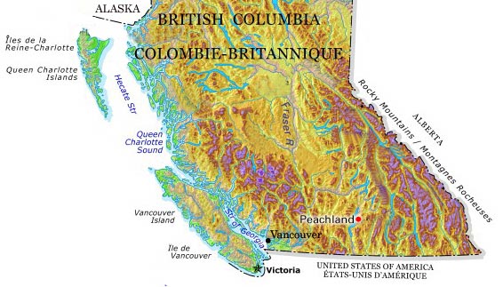
-
Article
Pelham
The rural-agricultural environment includes the Short Hills, vineyards, orchards and Canada's oldest sugar maple tree. There are sand quarries on the Fonthill Kame.
"https://development.thecanadianencyclopedia.ca/images/tce_placeholder.jpg?v=e9dca980c9bdb3aa11e832e7ea94f5d9" // resources/views/front/categories/view.blade.php
https://development.thecanadianencyclopedia.ca/images/tce_placeholder.jpg?v=e9dca980c9bdb3aa11e832e7ea94f5d9
-
Article
Pelly Crossing
Pelly Crossing, Yukon, settlement, population 353 (2016 census), 336 (2011 census). Pelly Crossing is located 254 km southeast of Dawson City and 273 km north of Whitehorse, on the Pelly River.
"https://development.thecanadianencyclopedia.ca/images/tce_placeholder.jpg?v=e9dca980c9bdb3aa11e832e7ea94f5d9" // resources/views/front/categories/view.blade.php
https://development.thecanadianencyclopedia.ca/images/tce_placeholder.jpg?v=e9dca980c9bdb3aa11e832e7ea94f5d9
-
Article
Pembroke
Long associated with the lumber trade, the city currently produces wood and paper products in addition to other light manufacturing. The seat of Renfrew County, it is also the commercial and service centre of the region.
"https://development.thecanadianencyclopedia.ca/images/tce_placeholder.jpg?v=e9dca980c9bdb3aa11e832e7ea94f5d9" // resources/views/front/categories/view.blade.php
https://development.thecanadianencyclopedia.ca/images/tce_placeholder.jpg?v=e9dca980c9bdb3aa11e832e7ea94f5d9