Browse "Cities & Populated Places"
-
Article
Pine Point
Pine Point, Northwest Territories, was a town located 10 km inland from the south shore of GREAT SLAVE LAKE , 87 km east of Hay River.
"https://development.thecanadianencyclopedia.ca/images/tce_placeholder.jpg?v=e9dca980c9bdb3aa11e832e7ea94f5d9" // resources/views/front/categories/view.blade.php
https://development.thecanadianencyclopedia.ca/images/tce_placeholder.jpg?v=e9dca980c9bdb3aa11e832e7ea94f5d9
-
Article
Pintendre
Pintendre, Quebec, population 7,171 (2019), 6,209 (2001 census). Originally incorporated in 1901, Pintendre is now part of Lévis since 2002. The area is located on the south bank of the St. Lawrence River. Pintendre is situated on the agricultural plain next to the Appalachian mountains. (See Mountain Range.) Three rivers flow through the area’s boundaries: Etchemin, la Scie and des Couture.
"https://d2ttikhf7xbzbs.cloudfront.net/media/media/fe50872c-9b16-4ab6-9cf3-8634facdf226.jpg" // resources/views/front/categories/view.blade.php
https://d2ttikhf7xbzbs.cloudfront.net/media/media/fe50872c-9b16-4ab6-9cf3-8634facdf226.jpg
-
Article
Pitt Meadows
Pitt Meadows, BC, incorporated as a city in 2007, population 17 736 (2011c), 15 623 (2006c). The City of Pitt Meadows is an agricultural community located in the lower Fraser Valley east of VANCOUVER on the north side of the FRASER RIVER at its junction with the Pitt River.
"https://development.thecanadianencyclopedia.ca/images/tce_placeholder.jpg?v=e9dca980c9bdb3aa11e832e7ea94f5d9" // resources/views/front/categories/view.blade.php
https://development.thecanadianencyclopedia.ca/images/tce_placeholder.jpg?v=e9dca980c9bdb3aa11e832e7ea94f5d9
-
Article
Place Royale
By bringing a bust of the king to Québec in 1686, Champigny was acquiescing to the request Louis XIV made of his intendants the previous year to create "places royales" in his honour in the various provinces of his kingdom.
"https://d2ttikhf7xbzbs.cloudfront.net/media/media/4f37bed7-b7b9-44eb-abca-05fffb732fb5.jpg" // resources/views/front/categories/view.blade.php
https://d2ttikhf7xbzbs.cloudfront.net/media/media/4f37bed7-b7b9-44eb-abca-05fffb732fb5.jpg
-
Article
Placentia
Placentia, NL, incorporated as a town in 1945, population 3643 (2011c), 3898 (2006c). The Town of Placentia is located on PLACENTIA BAY on the west coast of the AVALON PENINSULA.
"https://development.thecanadianencyclopedia.ca/images/tce_placeholder.jpg?v=e9dca980c9bdb3aa11e832e7ea94f5d9" // resources/views/front/categories/view.blade.php
https://development.thecanadianencyclopedia.ca/images/tce_placeholder.jpg?v=e9dca980c9bdb3aa11e832e7ea94f5d9
-
Article
Plessisville
Plessisville is named after Joseph-Octave Plessis, the eleventh bishop of Québec City. Plessisville was the first municipality developed in the Bois-Francs area. It had a rich, fertile soil ideal for agricultural development.
"https://d2ttikhf7xbzbs.cloudfront.net/media/media/396a361d-24d6-424a-b51f-b128a3b48bbd.jpg" // resources/views/front/categories/view.blade.php
https://d2ttikhf7xbzbs.cloudfront.net/media/media/396a361d-24d6-424a-b51f-b128a3b48bbd.jpg
-
Article
Pointe-au-Père
In 1663, the Jesuit priest Henri Nouvel landed on the south bank of the St Lawrence River and conducted the first mass. In 1696 this territory was the seigneurie de Lessard, granted to Pierre Lessard and Barbe Fortin, his wife.
"https://d2ttikhf7xbzbs.cloudfront.net/media/media/25f421c1-f50d-4f6f-9522-f72cc073a715.jpg" // resources/views/front/categories/view.blade.php
https://d2ttikhf7xbzbs.cloudfront.net/media/media/25f421c1-f50d-4f6f-9522-f72cc073a715.jpg
-
Article
Pointe-Claire
Pointe-Claire was first set up as a village municipality under the name of Saint-Joachim-de-la-Pointe-Claire in 1854. Its name was shortened when it was incorporated.
"https://development.thecanadianencyclopedia.ca/images/tce_placeholder.jpg?v=e9dca980c9bdb3aa11e832e7ea94f5d9" // resources/views/front/categories/view.blade.php
https://development.thecanadianencyclopedia.ca/images/tce_placeholder.jpg?v=e9dca980c9bdb3aa11e832e7ea94f5d9
-
Article
Ponoka
Ponoka, Alta, incorporated as a town in 1904, population 6773 (2011c), 6576 (2006c). The Town of Ponoka is located approximately 100 km south of Edmonton in rolling, rich parkbelt land. The Methodists established a mission to the Stoney at the nearby Samson Reserve in the late 1870s.
"https://development.thecanadianencyclopedia.ca/images/tce_placeholder.jpg?v=e9dca980c9bdb3aa11e832e7ea94f5d9" // resources/views/front/categories/view.blade.php
https://development.thecanadianencyclopedia.ca/images/tce_placeholder.jpg?v=e9dca980c9bdb3aa11e832e7ea94f5d9
-
Article
Port Alberni
Port Alberni, BC, incorporated as a city in 1967, population 17,678 (2016 c), 17,743 (2011 c). The present-day City of Port Alberni is the result of the 1967 amalgamation of two cities, Port Alberni (incorporated in 1912) and Alberni (incorporated in 1913). Port Alberni is located on central Vancouver Island, 195 km north of Victoria, at the head of Alberni Inlet, a deep fjord-like inlet that almost divides the island in two. The inlet was named after Don Pedro de Alberni, the Spanish officer in command of the Nootka garrison in 1791 during the Spanish occupation. In 1964, a tsunami caused by the Good Friday earthquake in Alaska moved up the inlet and hit the twin cities. About 375 houses were damaged, 55 of which were washed away, but there were no casualties.
"https://d2ttikhf7xbzbs.cloudfront.net/media/media/a4a66b07-c602-42f7-a156-77ed5d1334ff.jpg" // resources/views/front/categories/view.blade.php
https://d2ttikhf7xbzbs.cloudfront.net/media/media/a4a66b07-c602-42f7-a156-77ed5d1334ff.jpg
-
Article
Port au Choix
Port au Choix, NL, incorporated as a town in 1966, population 839 (2011c), 893 (2006c). The Town of Port au Choix is located on the west side of the Northern Peninsula.
"https://d2ttikhf7xbzbs.cloudfront.net/media/media/e18c8b0a-0307-4e37-b091-5665412f4aa5.jpg" // resources/views/front/categories/view.blade.php
https://d2ttikhf7xbzbs.cloudfront.net/media/media/e18c8b0a-0307-4e37-b091-5665412f4aa5.jpg
-
Article
Port Colborne
Port Colborne, Ontario, incorporated as a city in 1966, population 18,306 (2016 census), 18,424 (2011 census). The city of Port Colborne is located on Lake Erie and serves as the south port of entry to the Welland Canal. It was named for Sir John Colborne, a lieutenant-governor of Upper Canada.
"https://development.thecanadianencyclopedia.ca/images/tce_placeholder.jpg?v=e9dca980c9bdb3aa11e832e7ea94f5d9" // resources/views/front/categories/view.blade.php
https://development.thecanadianencyclopedia.ca/images/tce_placeholder.jpg?v=e9dca980c9bdb3aa11e832e7ea94f5d9
-
Article
Port Coquitlam
Port Coquitlam, British Columbia, incorporated as a city in 1913, population 61,498 (2021 census), 58,612 (2016 census). The City of Port Coquitlam is located on the Pitt and Fraser rivers, 27 km east of Vancouver. It is bounded on the north and west by the City of Coquitlam. It is a member of the Metro Vancouver Regional District and part of the Tri-Cities with Coquitlam and Port Moody.
"https://development.thecanadianencyclopedia.ca/images/tce_placeholder.jpg?v=e9dca980c9bdb3aa11e832e7ea94f5d9" // resources/views/front/categories/view.blade.php
https://development.thecanadianencyclopedia.ca/images/tce_placeholder.jpg?v=e9dca980c9bdb3aa11e832e7ea94f5d9
-
Article
Port Edward
Port Edward, BC, incorporated as a district municipality in 1991, population 544 (2011c), 577 (2006c). The District of Port Edward is located near PRINCE RUPERT on British Columbia's northern mainland coast, on Inverness Passage near the mouth of the SKEENA RIVER.
"https://development.thecanadianencyclopedia.ca/images/tce_placeholder.jpg?v=e9dca980c9bdb3aa11e832e7ea94f5d9" // resources/views/front/categories/view.blade.php
https://development.thecanadianencyclopedia.ca/images/tce_placeholder.jpg?v=e9dca980c9bdb3aa11e832e7ea94f5d9
-
Article
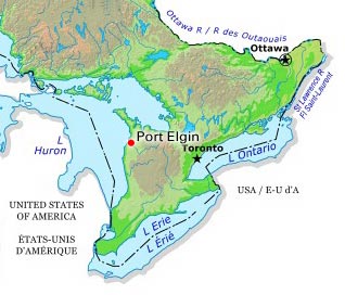
Port Elgin
Port Elgin, Ont, urban area, population 9,619 (2021 census), 8,297 (2016 census). Port Elgin is located on the shores of Lake Huron in Bruce County at the mouth of the Saugeen River, 48 km southwest of Owen Sound. A town from 1949 to 1999, it is now the administrative centre of the town of Saugeen Shores, which resulted from the amalgamation of Port Elgin with the town of Southampton and Saugeen Township.
"https://d2ttikhf7xbzbs.cloudfront.net/media/media/c954a74f-0922-4f98-9f82-90a754c95720.jpg" // resources/views/front/categories/view.blade.php
https://d2ttikhf7xbzbs.cloudfront.net/media/media/c954a74f-0922-4f98-9f82-90a754c95720.jpg