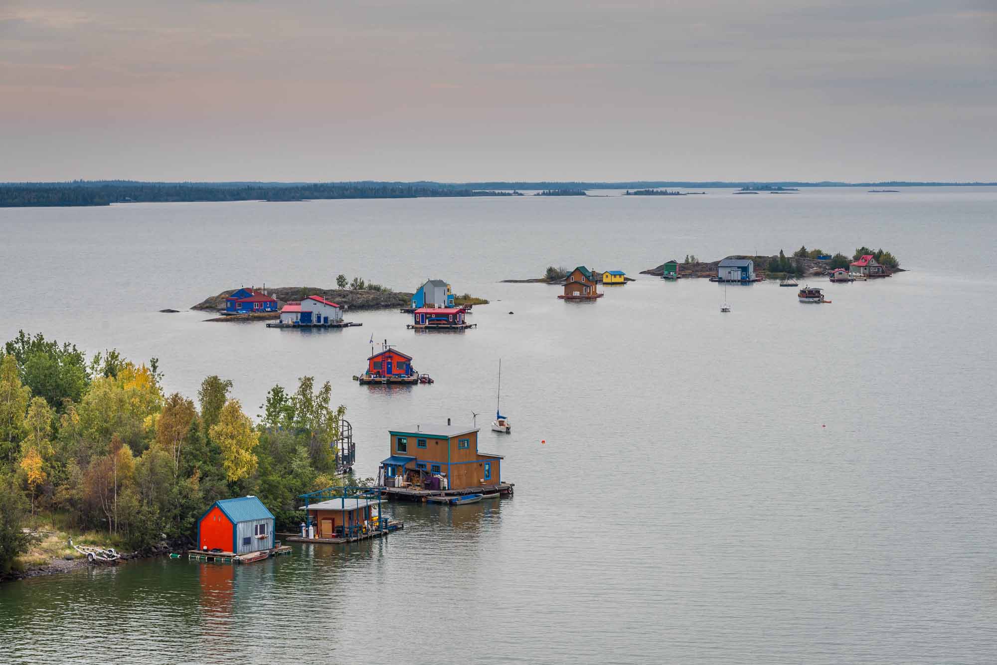
Great Bear Lake is located in the Northwest Territories. With a surface area of 31,328 km2, Great Bear Lake is the largest lake located entirely inside Canadian borders. It is also the fourth largest in North America and the eighth largest in the world. Water flows out of the lake into the Great Bear River, then into the Mackenzie River. Other rivers connected to the lake include the Dease, Camsell and Johnny Hoe. Great Bear Lake is made up of five separate arms, each with their own names: Dease, McTavish, McVicar, Keith and Smith. (See also Largest Lakes in Canada.)
Geography

The Dease Arm lies north of the Arctic Circle allowing for 24-hour daylight in summer. Great Bear Lake straddles the boundary between the Canadian Shield and the Interior Platform, as well as the northern boreal forest and tundra (see also Geological Regions; Forest Regions). The northeast shores of the lake feature sharp cliffs, numerous islands and fjord-like bays. By contrast, the southwest shores of the lake are flatter, with rich stands of spruce and large swaths of muskeg. The main elevation on this side of the lake is created by the Scented Grass Hills and Grizzly Bear Mountain.
Ecology
The rivers surrounding Great Bear Lake drain nutrient-poor lands, which, combined with a small watershed, colder temperatures and considerable depth (at its deepest point, Great Bear Lake reaches 452 metres), mean the lake supports relatively few plant and fish species. Of Canada’s large lakes, Great Bear Lake has the fewest number of different fish species (only 16). Because the fish do not migrate much within the lake, its five arms are home to unique populations.
History

Great Bear Lake is a part of the Yamoria legends — ancient Dene stories about giant heroes, animals, and living landscapes. In 1996, Grizzly Bear Mountain and the Scented Grass Hills (called Saoyú and Æehdacho in Slavey) were designated a national historic site. Saoyú and Æehdacho is Canada’s largest national historic site and serves to acknowledge and protect the importance of these landscapes to Dene narratives, culture and history.
Ancient and historic land use was by no means confined to this protected area, however. The north shore, for instance, connects Great Bear Lake to important areas for hunting caribou and muskoxen, and oral histories about this area detailed interactions between Dene and Inuvialuit.
Important fisheries were located where rivers meet the lake. The Johnny Hoe River flows into the McTavish Arm and was historically the site for a significant spring fishery. As with the north shore, the south shore and this fishery in particular encouraged contact between different Indigenous peoples. Tłı̨chǫ (Dogrib) and T’atsaot’ine (Yellowknives), fished here and sometimes came into conflict. Elsewhere, fast running waters at the meeting of Great Bear Lake and Great Bear River kept the surface from freezing, enabling year-round fishing for cisco — a practice that dates back at least 6,000 years. The value of the fisheries at this site, known as Délįne (“where the water flows”), made it highly attractive to traders and explorers who arrived in the region at the beginning of the 19th century. The North West Company established its Great Bear Lake post at Délįne in 1799 and explorer Sir John Franklin chose it as the location of Fort Franklin (his winter headquarters during his expedition in 1825–27). Franklin’s men amused themselves by skating and playing hockey on the ice of Great Bear Lake, one of the earliest recorded instances of the game being played in Canada.
Most of the current English names for Great Bear Lake and the surrounding area date from the fur trade period. The name of the lake itself likely originated from Alexander Mackenzie translating the Slavey words for “grizzly bear lake” as “great bear lake.” The five arms of the lake are named after members of the Hudson’s Bay Company who helped Franklin on his northern journeys.
During the fur trade period, most of the Indigenous peoples who lived around Great Bear Lake continued to move from place to place. The Idaà Trail, a portage route, connected Great Bear Lake with Great Slave Lake, and there were villages as well as hunting and fishing sites all along the way. Only after 1900 did more Dene settle at Délįne. Among them was Ehtseo (Grandfather) Ayah, an important Dene prophet, born in 1857. In 1921, Sahtu Dene signed Treaty 11 at Tulita (Fort Norman), where they often visited for trade. The entire lake was included within the treaty’s boundaries.

Significant change came to Great Bear Lake in 1930 when prospectors, drawn to the brightly coloured rocks on the lake’s eastern shore, identified a deposit rich in pitchblende and silver. Pitchblende is a dark, heavy radioactive mineral and the principal source of radium and uranium. The medical applications of radium, used to treat cancers in the early 20th century, made this a highly valuable find. A prospecting rush followed soon thereafter. By 1934, three mines had opened on Great Bear Lake. The largest — the Eldorado mine — was located at Cameron Bay (later Port Radium), the site of the original find.
Radium and silver were mined from Great Bear Lake until the Second World War, when labour shortages and decreased demand forced the mines to close by 1940. In 1942, the Canadian government secretly reopened the principal Eldorado mine in order to extract uranium (which had previously been disposed of as waste). Some of the uranium went to the Manhattan Project — an American research program that aimed to create nuclear weapons during the Second World War. Uranium mining continued on Great Bear Lake until the Eldorado mine closed again in 1960, while post-war silver mining took place between 1964 and 1982.
Most of the mine workers came to Great Bear Lake from southern Canada or farther afield. Mining companies hired Sahtu Dene as prospectors to find new ore deposits. Dene also sold meat and fish to people living and working at Port Radium, although many of the newcomers liked to fish and hunt for sport. Indeed, fishing by people at Port Radium, combined with the low biological productivity of the lake, meant that it did not take long for the fish stocks nearest to the mining operations to become depleted.
A federal government fisheries survey of Great Bear Lake, completed in 1944–45, described the lake as a “biological desert” and declared it permanently closed to commercial fishing operations. Domestic fishing by local Dene and sport fishing were permitted, however, and the lodges on the lake remain important tourism destinations for anglers.
Délįne expanded alongside Port Radium in the 1940s and 1950s, and more Dene settled in the community, particularly after the uranium mining operations ceased in 1960. As awareness of the hazards of radium and uranium mining increased in the later 20th century, the legacy of the mine operations on Great Bear Lake served as an important catalyst for political activism on the part of the Dene people living in Délįne (also known as Sahtúot’ine). In 1998, a group travelled to Hiroshima to express their great sadness that uranium taken from the shores of Great Bear Lake had been used as a weapon against distant people. Closer to home, Sahtúot’ine were leaders in advocating for protection and preservation of culturally significant landscapes on Great Bear Lake, pursuing research to study the health and environmental effects of the uranium mine, and negotiating for self-government. These negotiations culminated in the Sahtu Dene and Métis Comprehensive Land Claim Agreement, finalized in 1993 and incorporating Great Bear Lake, which resolved outstanding concerns about aboriginal and treaty rights that the Dene and Métis successfully argued had not been settled by Treaty 11 in 1921.
Environmental Concerns
The toxic legacy of historical mining operations on Great Bear Lake remains an environmental concern. Although uranium-rich tailings originally dumped on the lake bed were mostly removed as part of the 1950s mining operations, radioactive materials and heavy metals persist both in the lake and in surface ponds on the eastern shore. Recent research has demonstrated that heavy metals are accumulating in fish found near Port Radium in higher concentrations than elsewhere on the lake. Natural sources of mercury have contaminated fish from the Johnny Hoe River at high enough levels to be a health concern and, as a result, the formerly important domestic fishery at the site has been largely abandoned.

 Share on Facebook
 Share on X
 Share by Email
 Share on Google Classroom


