Browse "Districts and municipalities"
-
Article
Pinawa
Pinawa, Manitoba, incorporated as a local government district in 1963, population 1444 (2011c), 1450 (2006c). The Local Government District of Pinawa is located 110 km northeast of Winnipeg on the Winnipeg River at the entrance of the Pinawa Channel.
"https://development.thecanadianencyclopedia.ca/images/tce_placeholder.jpg?v=e9dca980c9bdb3aa11e832e7ea94f5d9" // resources/views/front/categories/view.blade.php
https://development.thecanadianencyclopedia.ca/images/tce_placeholder.jpg?v=e9dca980c9bdb3aa11e832e7ea94f5d9
-
Article
Pintendre
Pintendre, Quebec, population 7,171 (2019), 6,209 (2001 census). Originally incorporated in 1901, Pintendre is now part of Lévis since 2002. The area is located on the south bank of the St. Lawrence River. Pintendre is situated on the agricultural plain next to the Appalachian mountains. (See Mountain Range.) Three rivers flow through the area’s boundaries: Etchemin, la Scie and des Couture.
"https://d2ttikhf7xbzbs.cloudfront.net/media/media/fe50872c-9b16-4ab6-9cf3-8634facdf226.jpg" // resources/views/front/categories/view.blade.php
https://d2ttikhf7xbzbs.cloudfront.net/media/media/fe50872c-9b16-4ab6-9cf3-8634facdf226.jpg
-
Article
Pointe-au-Père
In 1663, the Jesuit priest Henri Nouvel landed on the south bank of the St Lawrence River and conducted the first mass. In 1696 this territory was the seigneurie de Lessard, granted to Pierre Lessard and Barbe Fortin, his wife.
"https://d2ttikhf7xbzbs.cloudfront.net/media/media/25f421c1-f50d-4f6f-9522-f72cc073a715.jpg" // resources/views/front/categories/view.blade.php
https://d2ttikhf7xbzbs.cloudfront.net/media/media/25f421c1-f50d-4f6f-9522-f72cc073a715.jpg
-
Article
Port Edward
Port Edward, BC, incorporated as a district municipality in 1991, population 544 (2011c), 577 (2006c). The District of Port Edward is located near PRINCE RUPERT on British Columbia's northern mainland coast, on Inverness Passage near the mouth of the SKEENA RIVER.
"https://development.thecanadianencyclopedia.ca/images/tce_placeholder.jpg?v=e9dca980c9bdb3aa11e832e7ea94f5d9" // resources/views/front/categories/view.blade.php
https://development.thecanadianencyclopedia.ca/images/tce_placeholder.jpg?v=e9dca980c9bdb3aa11e832e7ea94f5d9
-
Article
Port Hardy
Port Hardy, BC, incorporated as a district municipality in 1966, population 4008 (2011c), 3822 (2006c). The District of Port Hardy is located on the northeast coast of VANCOUVER ISLAND, 391 km by road north of NANAIMO.
"https://development.thecanadianencyclopedia.ca/images/tce_placeholder.jpg?v=e9dca980c9bdb3aa11e832e7ea94f5d9" // resources/views/front/categories/view.blade.php
https://development.thecanadianencyclopedia.ca/images/tce_placeholder.jpg?v=e9dca980c9bdb3aa11e832e7ea94f5d9
-
Article
Port Hope
Long a manufacturing and regional commercial centre, Port Hope's main street is one of the best preserved from late 19th-century Ontario. It is now a centre for uranium refining and the manufacture of machinery, tools, plastics and rubber.
"https://development.thecanadianencyclopedia.ca/images/tce_placeholder.jpg?v=e9dca980c9bdb3aa11e832e7ea94f5d9" // resources/views/front/categories/view.blade.php
https://development.thecanadianencyclopedia.ca/images/tce_placeholder.jpg?v=e9dca980c9bdb3aa11e832e7ea94f5d9
-
Article
Queens
Queens, NS, incorporated as a regional municipality in 1996, population 10 917 (2011c), 11 177 (2006c). The Region of Queens Municipality is located approximately 150 km southwest of Halifax.
"https://d2ttikhf7xbzbs.cloudfront.net/media/media/22724662-cbf7-461d-9649-5a5c6a3a3b7f.jpg" // resources/views/front/categories/view.blade.php
https://d2ttikhf7xbzbs.cloudfront.net/media/media/22724662-cbf7-461d-9649-5a5c6a3a3b7f.jpg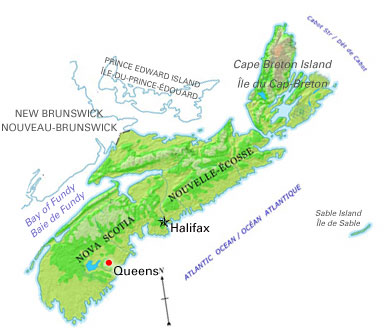
-
Article
Rockwood
Rockwood, Manitoba, incorporated as a rural municipality in 1880, population 7964 (2011c), 7692 (2006c). The Rural Municipality of Rockwood is located north of Winnipeg; it includes the communities of Stony Mountain, Grosse Isle, Argyle, Balmoral, Gunton and Komarno.
"https://development.thecanadianencyclopedia.ca/images/tce_placeholder.jpg?v=e9dca980c9bdb3aa11e832e7ea94f5d9" // resources/views/front/categories/view.blade.php
https://development.thecanadianencyclopedia.ca/images/tce_placeholder.jpg?v=e9dca980c9bdb3aa11e832e7ea94f5d9
-
Article
Russell (Ont)
Russell, Ontario, incorporated as a township in 1854, population 16,520 (2016 census), 15,247 (2011 census). The Township of Russell is located 33 km southeast of Ottawa. It was named after Peter Russell, an official in the government of Upper Canada.
"https://development.thecanadianencyclopedia.ca/images/tce_placeholder.jpg?v=e9dca980c9bdb3aa11e832e7ea94f5d9" // resources/views/front/categories/view.blade.php
https://development.thecanadianencyclopedia.ca/images/tce_placeholder.jpg?v=e9dca980c9bdb3aa11e832e7ea94f5d9
-
Article
Saanich
Saanich, BC, incorporated as a district municipality in 1906, population 109 752 (2011c), 108 265 (2006c). The District of Saanich is located immediately northwest of the city of VICTORIA, and is an integral part of the Greater Victoria area.
"https://d2ttikhf7xbzbs.cloudfront.net/media/media/8eb263da-d26b-4197-b26c-936471f19fe6.jpg" // resources/views/front/categories/view.blade.php
https://d2ttikhf7xbzbs.cloudfront.net/media/media/8eb263da-d26b-4197-b26c-936471f19fe6.jpg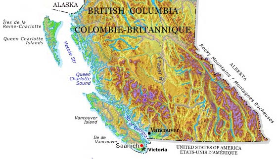
-
Article
Saint-Benoît-du-Lac
The community was founded by Dom Paul Vannier in 1912 when he acquired a farm at Point Gibraltar, a peninsula sloping down towards the lake. He and 3 other monks began farming and providing religious services.
"https://d2ttikhf7xbzbs.cloudfront.net/media/media/31ddf4eb-2a59-4969-932c-cea873fe5f25.jpg" // resources/views/front/categories/view.blade.php
https://d2ttikhf7xbzbs.cloudfront.net/media/media/31ddf4eb-2a59-4969-932c-cea873fe5f25.jpg
-
Article
Saint-Charles-Borromée
Saint-Charles-Borromée was at one time an agricultural village but is now almost totally residential. It is a suburb of Montréal and Joliette. There is no industrial zone, so economic activity is almost exclusively commercial. The hospital is the largest employer.
"https://d2ttikhf7xbzbs.cloudfront.net/media/media/658ad4b0-7b40-456f-a582-61e2305fc015.jpg" // resources/views/front/categories/view.blade.php
https://d2ttikhf7xbzbs.cloudfront.net/media/media/658ad4b0-7b40-456f-a582-61e2305fc015.jpg
-
Article
Saint-Charles-sur-Richelieu
Like many places in the lower Richelieu region, Saint-Charles experienced a decline in the second half of the 19th century. Towards the end of the century, one of the village's activities was the transportation of oats to New York City for use as feed for tramway horses.
"https://development.thecanadianencyclopedia.ca/images/tce_placeholder.jpg?v=e9dca980c9bdb3aa11e832e7ea94f5d9" // resources/views/front/categories/view.blade.php
https://development.thecanadianencyclopedia.ca/images/tce_placeholder.jpg?v=e9dca980c9bdb3aa11e832e7ea94f5d9
-
Article
Saint-Denis-sur-Richelieu
During the REBELLIONS OF 1837 it became a centre for the PATRIOTES who fought against and forced the retreat of Colonel Charles Gore's troops. In retaliation, the village was burned (see ST-DENIS, BATTLE OF).
"https://development.thecanadianencyclopedia.ca/images/tce_placeholder.jpg?v=e9dca980c9bdb3aa11e832e7ea94f5d9" // resources/views/front/categories/view.blade.php
https://development.thecanadianencyclopedia.ca/images/tce_placeholder.jpg?v=e9dca980c9bdb3aa11e832e7ea94f5d9
-
Article
Saint-Honoré
Saint-Honoré, still rural in character, is best known for its flying school, Centre québécois deformation aéronautique of the CÉGEP de Chicoutimi, and for Niobec Inc, one of the world's main producers of COLUMBIUM, a mineral used in the manufacture of steel alloys.
"https://d2ttikhf7xbzbs.cloudfront.net/media/media/42288766-f783-4af8-a15d-2b97aef5f655.jpg" // resources/views/front/categories/view.blade.php
https://d2ttikhf7xbzbs.cloudfront.net/media/media/42288766-f783-4af8-a15d-2b97aef5f655.jpg