Browse "Towns"
-
Article
Hampton
Hampton, NB, incorporated as a town in 1991, population 4292 (2011c), 4004 (2006c). The Town of Hampton is situated 37 km northeast of SAINT JOHN on the Kennebecasis River.
"https://development.thecanadianencyclopedia.ca/images/tce_placeholder.jpg?v=e9dca980c9bdb3aa11e832e7ea94f5d9" // resources/views/front/categories/view.blade.php
https://development.thecanadianencyclopedia.ca/images/tce_placeholder.jpg?v=e9dca980c9bdb3aa11e832e7ea94f5d9
-
Article
Hanna
Hanna, Alta, incorporated as a town in 1914, population 2673 (2011c), 2847 (2006c). The Town of Hanna is situated 219 km northeast of Calgary and was named after David B. HANNA, 3rd vice-president of the Canadian Northern Railway, and was first settled in 1912.
"https://development.thecanadianencyclopedia.ca/images/tce_placeholder.jpg?v=e9dca980c9bdb3aa11e832e7ea94f5d9" // resources/views/front/categories/view.blade.php
https://development.thecanadianencyclopedia.ca/images/tce_placeholder.jpg?v=e9dca980c9bdb3aa11e832e7ea94f5d9
-
Article
Hanover (Ont)
Hanover, Ont, incorporated as a town in 1904, population 7490 (2011c), 7147 (2006c). The Town of Hanover is located 70 km southwest of OWEN SOUND on the Saugeen River.
"https://d2ttikhf7xbzbs.cloudfront.net/media/media/0ae492cf-0c8f-489c-9da4-cdd28d818051.jpg" // resources/views/front/categories/view.blade.php
https://d2ttikhf7xbzbs.cloudfront.net/media/media/0ae492cf-0c8f-489c-9da4-cdd28d818051.jpg
-
Article
Happy Valley-Goose Bay
Happy Valley-Goose Bay, Newfoundland and Labrador, incorporated as a town in 1973, population 8,109 (2016 census), 7,552 (2011 census). The town of Happy Valley-Goose Bay is the result of the amalgamation of two towns situated at the western end of Hamilton Inlet, Labrador. The community began with the construction of an air base during the Second World War. It remains home to a Canadian Forces Base and a small civilian population.
"https://d2ttikhf7xbzbs.cloudfront.net/media/media/dcdb9156-1ed7-43df-b8d3-36f7d617cd41.jpg" // resources/views/front/categories/view.blade.php
https://d2ttikhf7xbzbs.cloudfront.net/media/media/dcdb9156-1ed7-43df-b8d3-36f7d617cd41.jpg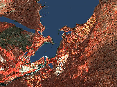
-
Article
Harbour Breton
Harbour Breton, NL, incorporated as a town in 1952, population 1711 (2011c), 1877 (2006c). The Town of Harbour Breton is situated around a protected harbour near the mouth of Fortune Bay on Newfoundland's south coast.
"https://development.thecanadianencyclopedia.ca/images/tce_placeholder.jpg?v=e9dca980c9bdb3aa11e832e7ea94f5d9" // resources/views/front/categories/view.blade.php
https://development.thecanadianencyclopedia.ca/images/tce_placeholder.jpg?v=e9dca980c9bdb3aa11e832e7ea94f5d9
-
Article
Harbour Grace
Harbour Grace, NL, incorporated as a town in 1945, population 3131 (2011c), 3074 (2006c). The Town of Harbour Grace, with its commodious harbour in western Conception Bay, was named for the French Havre de Grâce.
"https://development.thecanadianencyclopedia.ca/images/tce_placeholder.jpg?v=e9dca980c9bdb3aa11e832e7ea94f5d9" // resources/views/front/categories/view.blade.php
https://development.thecanadianencyclopedia.ca/images/tce_placeholder.jpg?v=e9dca980c9bdb3aa11e832e7ea94f5d9
-
Article
Hartland
Hartland, NB, incorporated as a town in 1918, population 947 (2011c), 947 (2006c). The Town of Hartland is located at the mouth of Becaguimec Stream, 124 km upriver from Fredericton on the SAINT JOHN RIVER.
"https://d2ttikhf7xbzbs.cloudfront.net/media/media/47b24fcb-cb02-4988-ac93-8d8199dd5a7f.jpg" // resources/views/front/categories/view.blade.php
https://d2ttikhf7xbzbs.cloudfront.net/media/media/47b24fcb-cb02-4988-ac93-8d8199dd5a7f.jpg
-
Article
Hawkesbury
Hawkesbury, Ontario, incorporated as a town in 1896, population 10,263 (2016 census), 10,551 (2011 census). The town of Hawkesbury is located on the Ottawa River, 95 km east of Ottawa.
"https://development.thecanadianencyclopedia.ca/images/tce_placeholder.jpg?v=e9dca980c9bdb3aa11e832e7ea94f5d9" // resources/views/front/categories/view.blade.php
https://development.thecanadianencyclopedia.ca/images/tce_placeholder.jpg?v=e9dca980c9bdb3aa11e832e7ea94f5d9
-
Article
Hearst
Hearst, Ont, incorporated as a town in 1922, population 5090 (2011c), 5620 (2006c). The Town of Hearst is situated in the Cochrane District of northeastern Ontario on the Mattawishkwia River, 260 km northwest of TIMMINS.
"https://development.thecanadianencyclopedia.ca/images/tce_placeholder.jpg?v=e9dca980c9bdb3aa11e832e7ea94f5d9" // resources/views/front/categories/view.blade.php
https://development.thecanadianencyclopedia.ca/images/tce_placeholder.jpg?v=e9dca980c9bdb3aa11e832e7ea94f5d9
-
Article
Heart's Content
Heart's Content, NL, incorporated as a town in 1967, population 418 (2011c), 418 (2006c). The Town of Heart's Content is a fishing community on a protected, urn-shaped harbour in eastern Trinity Bay.
"https://development.thecanadianencyclopedia.ca/images/tce_placeholder.jpg?v=e9dca980c9bdb3aa11e832e7ea94f5d9" // resources/views/front/categories/view.blade.php
https://development.thecanadianencyclopedia.ca/images/tce_placeholder.jpg?v=e9dca980c9bdb3aa11e832e7ea94f5d9
-
Article
High Level
High Level, Alta, incorporated as a town in 1983, population 3641 (2011c), 3887 (2006c). The Town of High Level is located 250 km north of the town of PEACE RIVER and was named for a high expanse of land separating the Hay and PEACE river systems.
"https://development.thecanadianencyclopedia.ca/images/tce_placeholder.jpg?v=e9dca980c9bdb3aa11e832e7ea94f5d9" // resources/views/front/categories/view.blade.php
https://development.thecanadianencyclopedia.ca/images/tce_placeholder.jpg?v=e9dca980c9bdb3aa11e832e7ea94f5d9
-
"https://development.thecanadianencyclopedia.ca/images/tce_placeholder.jpg?v=e9dca980c9bdb3aa11e832e7ea94f5d9" // resources/views/front/categories/view.blade.php
https://development.thecanadianencyclopedia.ca/images/tce_placeholder.jpg?v=e9dca980c9bdb3aa11e832e7ea94f5d9
-
Article
Holyrood
Holyrood, NL, incorporated as a town in 1969, population 1995 (2011c), 2005 (2006c). The Town of Holyrood is located at the head of Conception Bay on the Avalon Peninsula about 50 km west of St John's.
"https://development.thecanadianencyclopedia.ca/images/tce_placeholder.jpg?v=e9dca980c9bdb3aa11e832e7ea94f5d9" // resources/views/front/categories/view.blade.php
https://development.thecanadianencyclopedia.ca/images/tce_placeholder.jpg?v=e9dca980c9bdb3aa11e832e7ea94f5d9
-
Article
Hudson Bay (Sask)
By the end of WWII the community had grown sufficiently to obtain town status, a fact emphasized by dropping "Junction" from its name (1947). Since then, while growth has continued, the economy has been modified.
"https://development.thecanadianencyclopedia.ca/images/tce_placeholder.jpg?v=e9dca980c9bdb3aa11e832e7ea94f5d9" // resources/views/front/categories/view.blade.php
https://development.thecanadianencyclopedia.ca/images/tce_placeholder.jpg?v=e9dca980c9bdb3aa11e832e7ea94f5d9
-
Article
Humboldt
Its designation as a railway divisional point fostered growth, as did the establishment of St Peters Colony (50 townships) by the Roman Catholic Order of St Benedict (1903).
"https://development.thecanadianencyclopedia.ca/images/tce_placeholder.jpg?v=e9dca980c9bdb3aa11e832e7ea94f5d9" // resources/views/front/categories/view.blade.php
https://development.thecanadianencyclopedia.ca/images/tce_placeholder.jpg?v=e9dca980c9bdb3aa11e832e7ea94f5d9