Browse "Towns"
-
Article
Saint Andrews (NB)
Saint Andrews, NB, incorporated as a town in 1903, population 1889 (2011c), 1798 (2006c). The Town of Saint Andrews is located at the mouth of the ST CROIX RIVER in the southwest corner of New Brunswick.
"https://development.thecanadianencyclopedia.ca/images/tce_placeholder.jpg?v=e9dca980c9bdb3aa11e832e7ea94f5d9" // resources/views/front/categories/view.blade.php
https://development.thecanadianencyclopedia.ca/images/tce_placeholder.jpg?v=e9dca980c9bdb3aa11e832e7ea94f5d9
-
Article
Saint-Basile-le-Grand
Saint-Basile-le-Grand, Qué, Town, pop 15 605 (2006c), 12 385 (2001c), inc 1969. Saint-Basile-le-Grand is located between Mont Saint-Bruno and the Rivière RICHELIEU about 35 km east of MONTRÉAL.
"https://development.thecanadianencyclopedia.ca/images/tce_placeholder.jpg?v=e9dca980c9bdb3aa11e832e7ea94f5d9" // resources/views/front/categories/view.blade.php
https://development.thecanadianencyclopedia.ca/images/tce_placeholder.jpg?v=e9dca980c9bdb3aa11e832e7ea94f5d9
-
Article
Saint-Jean-Chrysostome
Saint-Jean-Chrysostome, Quebec, population 18,352 (2019), 17,089 (2001 census). Saint-Jean-Chrysostome is located on the south bank of the St. Lawrence River. It is some 20 km south of Quebec City in the Chaudière-Appalaches Region. This region is characterized by fertile agricultural plains, plateaus and the majestic Appalachian mountains. (See Mountain Range.) Originally incorporated in 1965, Saint-Jean-Chrysostome became part of .
"https://d2ttikhf7xbzbs.cloudfront.net/media/media/fff2605f-e1c7-4789-b999-075715b3149b.jpg" // resources/views/front/categories/view.blade.php
https://d2ttikhf7xbzbs.cloudfront.net/media/media/fff2605f-e1c7-4789-b999-075715b3149b.jpg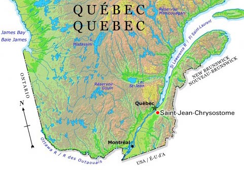
-
Article
Saint-Léonard (NB)
Saint-Léonard, NB, incorporated as a town in 1920, population 1343 (2011c), 1352 (2006c).
"https://development.thecanadianencyclopedia.ca/images/tce_placeholder.jpg?v=e9dca980c9bdb3aa11e832e7ea94f5d9" // resources/views/front/categories/view.blade.php
https://development.thecanadianencyclopedia.ca/images/tce_placeholder.jpg?v=e9dca980c9bdb3aa11e832e7ea94f5d9
-
Article
Saint-Quentin
Saint-Quentin, NB, incorporated as a town in 1992, population 2095 (2011c), 2250 (2006c). The Town of Saint-Quentin is located in northern New Brunswick in the Appalachian Highlands between the RESTIGOUCHE and MIRAMICHI rivers and tributaries of the SAINT JOHN RIVER.
"https://development.thecanadianencyclopedia.ca/images/tce_placeholder.jpg?v=e9dca980c9bdb3aa11e832e7ea94f5d9" // resources/views/front/categories/view.blade.php
https://development.thecanadianencyclopedia.ca/images/tce_placeholder.jpg?v=e9dca980c9bdb3aa11e832e7ea94f5d9
-
Article
Saint-Raymond
Saint-Raymond's industrial activity has always been closely linked to the forest industry. Sawmilling, pulp and paper, wood products, house and cottage manufacturing as well as charcoal production, are still key economic activities.
"https://d2ttikhf7xbzbs.cloudfront.net/media/media/eafda8a7-b679-46ed-bcc0-bd5a00bdc540.jpg" // resources/views/front/categories/view.blade.php
https://d2ttikhf7xbzbs.cloudfront.net/media/media/eafda8a7-b679-46ed-bcc0-bd5a00bdc540.jpg
-
Article
Sainte-Adèle
Sainte-Adèle, Qué, Town, pop 10 634 (2006c), 9215 (2001c), inc 1965. Sainte-Adèle is situated in the Laurentides region about 60 km north of Montréal. The Laurentides and Mont-Tremblant provincial parks are found to the north. In 1997 Sainte-Adèle annexed the village of Mont-Rolland (pop 2882, 1996c).
"https://d2ttikhf7xbzbs.cloudfront.net/media/media/b5046a48-3bfb-4a94-acd7-52ad59bde3da.jpg" // resources/views/front/categories/view.blade.php
https://d2ttikhf7xbzbs.cloudfront.net/media/media/b5046a48-3bfb-4a94-acd7-52ad59bde3da.jpg
-
Article
Sainte-Agathe-des-Monts
In the 19th century, Sainte-Agathe had only a few sawmills, but the construction of the Montreal and Occidental Railway in 1892 (replaced by the CPR in 1900) encouraged tourism and the development of the hotels that have become the region's economic mainstay.
"https://development.thecanadianencyclopedia.ca/images/tce_placeholder.jpg?v=e9dca980c9bdb3aa11e832e7ea94f5d9" // resources/views/front/categories/view.blade.php
https://development.thecanadianencyclopedia.ca/images/tce_placeholder.jpg?v=e9dca980c9bdb3aa11e832e7ea94f5d9
-
Article
Sainte-Anne-de-Bellevue
Sainte-Anne-de-Bellevue, Qué, Town, pop 5197 (2006c), 5062 (2001c), inc 1895. Sainte-Anne-de-Bellevue is located on the western tip of Île de Montréal, about 35 km west of MONTRÉAL.
"https://development.thecanadianencyclopedia.ca/images/tce_placeholder.jpg?v=e9dca980c9bdb3aa11e832e7ea94f5d9" // resources/views/front/categories/view.blade.php
https://development.thecanadianencyclopedia.ca/images/tce_placeholder.jpg?v=e9dca980c9bdb3aa11e832e7ea94f5d9
-
Article
Sainte-Anne-des-Monts
In 1863 the area became known as the Parish of Sainte-Anne-des-Monts. The first settlers named it in memory of their native parish of Sainte-Anne-de-la-Pocatière in France. In 1968, it became the city of Sainte-Anne-des-Monts.
"https://d2ttikhf7xbzbs.cloudfront.net/media/media/ad9f83cd-9898-46fb-a508-c0f481a5a549.jpg" // resources/views/front/categories/view.blade.php
https://d2ttikhf7xbzbs.cloudfront.net/media/media/ad9f83cd-9898-46fb-a508-c0f481a5a549.jpg
-
Article
Sault Ste Marie
Sault Ste Marie, Ontario, incorporated as a town in 1887 and as a city in 1912, population 72,051 (2021 census), 73,368 (2016 census). The city of Sault Ste Marie is located adjacent to the rapids of the St Marys River between lakes Superior and Huron. Across the river is the American city of the same name. Sault Ste Marie sits on the traditional territory of the Ojibwe, who called the site Bawating (“place of the rapids”) and valued it for its access to the upper Great Lakes and as a source of abundant whitefish and maple sugar. It is popularly called “the Sault,” or “Soo.”
"https://d2ttikhf7xbzbs.cloudfront.net/media/media/a1557c26-bfa4-48ad-aef1-724137f63990.jpg" // resources/views/front/categories/view.blade.php
https://d2ttikhf7xbzbs.cloudfront.net/media/media/a1557c26-bfa4-48ad-aef1-724137f63990.jpg
-
Article
Schefferville
Schefferville, Quebec, incorporated as a town in 1955, population 155 (2016 census), 213 (2011 census). Schefferville is located between Knob and Pearce Lakes, on Quebec’s border with Labrador, 510 km north of Sept-Îles.
"https://d2ttikhf7xbzbs.cloudfront.net/media/new_article_images/Schefferville/Schefferville_2013.jpg" // resources/views/front/categories/view.blade.php
https://d2ttikhf7xbzbs.cloudfront.net/media/new_article_images/Schefferville/Schefferville_2013.jpg
-
Article
Selkirk
Selkirk, Manitoba, incorporated as a town in 1882 and as a city in 1998, population 10,504 (2021 census), 10,278 (2016 census). The City of Selkirk is located on the west bank of the Red River, 29 km north of Winnipeg. The city was named after Thomas Douglas, Fifth Earl of Selkirk.
"https://development.thecanadianencyclopedia.ca/images/tce_placeholder.jpg?v=e9dca980c9bdb3aa11e832e7ea94f5d9" // resources/views/front/categories/view.blade.php
https://development.thecanadianencyclopedia.ca/images/tce_placeholder.jpg?v=e9dca980c9bdb3aa11e832e7ea94f5d9
-
Article
Senneterre
Senneterre, Qué, Town, pop 2993 (2006c), 3275 (2001c), inc 1956. Senneterre is located 130 km east of ROUYN-NORANDA along the banks of the Rivière Bell in Québec's Abitibi-Témiscamingue region. It was
"https://development.thecanadianencyclopedia.ca/images/tce_placeholder.jpg?v=e9dca980c9bdb3aa11e832e7ea94f5d9" // resources/views/front/categories/view.blade.php
https://development.thecanadianencyclopedia.ca/images/tce_placeholder.jpg?v=e9dca980c9bdb3aa11e832e7ea94f5d9
-
Article
Shaunavon
During the late 19th and early 20th centuries ranching was the primary activity in the area and from 1910 the ranchers were forced to share the land with grain farmers. In 1913 the CPR extended its line into the area and the Shaunavon site developed.
"https://development.thecanadianencyclopedia.ca/images/tce_placeholder.jpg?v=e9dca980c9bdb3aa11e832e7ea94f5d9" // resources/views/front/categories/view.blade.php
https://development.thecanadianencyclopedia.ca/images/tce_placeholder.jpg?v=e9dca980c9bdb3aa11e832e7ea94f5d9