Browse "Towns"
-
Article
Stettler
Stettler, Alta, incorporated as a town in 1906, population 5748 (2011c), 5445 (2006c). The Town of Stettler, the county seat for County of Stettler, is located on the rolling prairie of south-central Alberta 203 km southeast of Edmonton on a creek flowing north to the Battle River.
"https://development.thecanadianencyclopedia.ca/images/tce_placeholder.jpg?v=e9dca980c9bdb3aa11e832e7ea94f5d9" // resources/views/front/categories/view.blade.php
https://development.thecanadianencyclopedia.ca/images/tce_placeholder.jpg?v=e9dca980c9bdb3aa11e832e7ea94f5d9
-
Article
Stonewall
Stonewall, Manitoba, incorporated as a town in 1908, population 4536 (2011c), 4376 (2006c). The Town of Stonewall is located 24 km northwest of Winnipeg on a limestone outcrop in the southern Interlake.
"https://development.thecanadianencyclopedia.ca/images/tce_placeholder.jpg?v=e9dca980c9bdb3aa11e832e7ea94f5d9" // resources/views/front/categories/view.blade.php
https://development.thecanadianencyclopedia.ca/images/tce_placeholder.jpg?v=e9dca980c9bdb3aa11e832e7ea94f5d9
-
Article
Stony Plain
Stony Plain, Alta, incorporated as a town in 1908, population 15 051 (2011c), 12 363 (2006c). The Town of Stony Plain is located about 25 km west of EDMONTON. Settlement began in 1881 about 3 km south of the present town. This settlement was called Dogrump Creek but in 1892 was renamed Stony Plain.
"https://development.thecanadianencyclopedia.ca/images/tce_placeholder.jpg?v=e9dca980c9bdb3aa11e832e7ea94f5d9" // resources/views/front/categories/view.blade.php
https://development.thecanadianencyclopedia.ca/images/tce_placeholder.jpg?v=e9dca980c9bdb3aa11e832e7ea94f5d9
-
Article
Strathmore
Strathmore, Alta, incorporated as a town in 1911, population 12 305 (2011c), 10 280 (2006c). The Town of Strathmore is located 40 km east of CALGARY. Strathmore was named after Charles Bowes-Lyon, 13th earl of Strathmore (1824-1904), a forefather of Queen Elizabeth II.
"https://d2ttikhf7xbzbs.cloudfront.net/media/media/210a4861-11eb-4238-97ad-3bdd221a3b60.jpg" // resources/views/front/categories/view.blade.php
https://d2ttikhf7xbzbs.cloudfront.net/media/media/210a4861-11eb-4238-97ad-3bdd221a3b60.jpg
-
Article
Strathroy-Caradoc
During its early history Strathroy suffered a number of devastating fires. In 1868 a blaze wiped out a considerable portion of Strathroy's business section. Several fires in manufacturing plants in the late 1890s and an agricultural depression caused a period of economic downturn for the town.
"https://d2ttikhf7xbzbs.cloudfront.net/media/media/997b9858-a7a8-4f8a-8880-76bd7d7f9b96.jpg" // resources/views/front/categories/view.blade.php
https://d2ttikhf7xbzbs.cloudfront.net/media/media/997b9858-a7a8-4f8a-8880-76bd7d7f9b96.jpg
-
Article
Summerside
Beginning around 1910, the town experienced renewed prosperity as a fur-trading centre, stimulated by Sir Charles Dalton and Robert T. Oulton's successful breeding of silver foxes in captivity. In 1920 Summerside was established as the headquarters of the Canadian National Silver Fox Breeders' Assn.
"https://d2ttikhf7xbzbs.cloudfront.net/media/media/c92b22e5-2797-46d3-bd33-d318ecb6cc64.jpg" // resources/views/front/categories/view.blade.php
https://d2ttikhf7xbzbs.cloudfront.net/media/media/c92b22e5-2797-46d3-bd33-d318ecb6cc64.jpg
-
"https://d2ttikhf7xbzbs.cloudfront.net/media/media/a75c407d-aa04-450d-9516-94bdc0f4f3f3.jpg" // resources/views/front/categories/view.blade.php
https://d2ttikhf7xbzbs.cloudfront.net/media/media/a75c407d-aa04-450d-9516-94bdc0f4f3f3.jpg
-
Article
Sussex
Sussex, New Brunswick, incorporated as a town in 1904, population 4,440 (2021 census), 4,282 (2016 census). The Town of Sussex is located in south-central New Brunswick in a rich agricultural area, 73 km from Saint John on the Kennebecasis River.
"https://development.thecanadianencyclopedia.ca/images/tce_placeholder.jpg?v=e9dca980c9bdb3aa11e832e7ea94f5d9" // resources/views/front/categories/view.blade.php
https://development.thecanadianencyclopedia.ca/images/tce_placeholder.jpg?v=e9dca980c9bdb3aa11e832e7ea94f5d9
-
Article
Swan Hills
Swan Hills, Alta, incorporated as a town in 1967, population 1465 (2011c), 1645 (2006c). The Town of Swan Hills is located in the Swan Hills, 209 km northwest of Edmonton. The Swan Hills were named by the Cree for legendary giant swans whose thundering wings would fill the air.
"https://d2ttikhf7xbzbs.cloudfront.net/media/media/c832dba4-b8a8-4794-a903-4d960dbe55b2.jpg" // resources/views/front/categories/view.blade.php
https://d2ttikhf7xbzbs.cloudfront.net/media/media/c832dba4-b8a8-4794-a903-4d960dbe55b2.jpg
-
Article
Taber
Taber, Alberta, incorporated as a town in 1907, population 8,428 (2016 census), 8,104 (2011 census). The town of Taber is located 50 km east of Lethbridge.
"https://development.thecanadianencyclopedia.ca/images/tce_placeholder.jpg?v=e9dca980c9bdb3aa11e832e7ea94f5d9" // resources/views/front/categories/view.blade.php
https://development.thecanadianencyclopedia.ca/images/tce_placeholder.jpg?v=e9dca980c9bdb3aa11e832e7ea94f5d9
-
Article
Tecumseh (Ont)
Tecumseh, Ont, incorporated as a town in 1921, population 23 610 (2011c), 24 224 (2006c). The Town of Tecumseh is located in southeastern Ontario east of the city of Windsor on Lake St Clair.
"https://d2ttikhf7xbzbs.cloudfront.net/media/media/384b1ecf-7db5-462b-8215-1931165f09c7.jpg" // resources/views/front/categories/view.blade.php
https://d2ttikhf7xbzbs.cloudfront.net/media/media/384b1ecf-7db5-462b-8215-1931165f09c7.jpg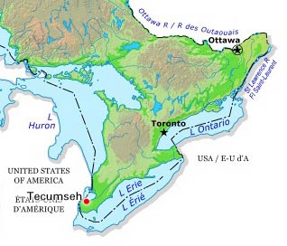
-
Article
Témiscaming
Témiscaming, Quebec, incorporated as a town in 1988, population 2,368 (2021 census), 2,431 (2016 census). Témiscaming is located at the southern end of Lac Témiscamingue (spelled Timiskaming in Ontario) near the rapids that link the lake with the Ottawa River. In 1888, a sawmill was built nearby.
"https://development.thecanadianencyclopedia.ca/images/tce_placeholder.jpg?v=e9dca980c9bdb3aa11e832e7ea94f5d9" // resources/views/front/categories/view.blade.php
https://development.thecanadianencyclopedia.ca/images/tce_placeholder.jpg?v=e9dca980c9bdb3aa11e832e7ea94f5d9
-
Article
The Pas
The Pas, Manitoba, incorporated as a town in 1912, population 5,639 (2021 census), 5,369 (2016 census). The town of The Pas is located on the south bank of the Saskatchewan River, about 60 km northwest of where the river enters Cedar Lake.
"https://development.thecanadianencyclopedia.ca/images/tce_placeholder.jpg?v=e9dca980c9bdb3aa11e832e7ea94f5d9" // resources/views/front/categories/view.blade.php
https://development.thecanadianencyclopedia.ca/images/tce_placeholder.jpg?v=e9dca980c9bdb3aa11e832e7ea94f5d9
-
Article
Three Hills
Three Hills, Alta, incorporated as a town in 1929, population 3198 (2011c), 3089 (2006c). The Town of Three Hills is located 128 km northeast of Calgary. Three Hills takes its name from 3 prominent hills to the north of the town.
"https://d2ttikhf7xbzbs.cloudfront.net/media/media/5ecb9aa6-e6d7-420b-a068-c8a30e4d9c1c.jpg" // resources/views/front/categories/view.blade.php
https://d2ttikhf7xbzbs.cloudfront.net/media/media/5ecb9aa6-e6d7-420b-a068-c8a30e4d9c1c.jpg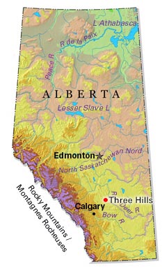
-
Article
Tillsonburg
Tillsonburg, Ont, incorporated as a town in 1872, population 15 301 (2011c), 14 822 (2006c). The Town of Tillsonburg is located in Oxford County, 40 km east of ST THOMAS. Founder George Tillson arrived in 1825 and opened a forge
"https://development.thecanadianencyclopedia.ca/images/tce_placeholder.jpg?v=e9dca980c9bdb3aa11e832e7ea94f5d9" // resources/views/front/categories/view.blade.php
https://development.thecanadianencyclopedia.ca/images/tce_placeholder.jpg?v=e9dca980c9bdb3aa11e832e7ea94f5d9