Browse "Villages"
-
Article
Fort Steele
From 1892 to the present, mining (gold, lead, zinc and silver) has been an important part of the economic development of the immediate region. The construction of the BC Southern Railway to Cranbrook in 1898 sealed the fate of Fort Steele, which quickly faded.
"https://d2ttikhf7xbzbs.cloudfront.net/media/media/a64c2753-6c2c-4abe-a75b-d9e9202495e4.jpg" // resources/views/front/categories/view.blade.php
https://d2ttikhf7xbzbs.cloudfront.net/media/media/a64c2753-6c2c-4abe-a75b-d9e9202495e4.jpg
-
Article
Fort Vermilion
Fort Vermilion, Alta, Unincorporated Place, population 727 (2011c), 714 (2006c). Fort Vermilion is located about 70 km east of HIGH LEVEL and is one of the communities of Mackenzie County. The name Fort Vermilion refers to the red ochre found in the area.
"https://d2ttikhf7xbzbs.cloudfront.net/media/media/7b54f899-613a-4dce-8a8b-8e0971b7f4fa.jpg" // resources/views/front/categories/view.blade.php
https://d2ttikhf7xbzbs.cloudfront.net/media/media/7b54f899-613a-4dce-8a8b-8e0971b7f4fa.jpg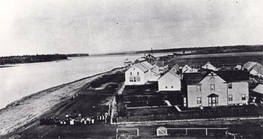
-
Article
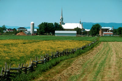
Fruitvale
Fruitvale, BC, incorporated as a village in 1952, population 2016 (2011c), 1952 (2006c). The Village of Fruitvale is located in the southern interior of BC close to the US border, 11 km east of TRAIL, 645 km east of Vancouver.
"https://d2ttikhf7xbzbs.cloudfront.net/media/media/0f6874e9-2706-4ff6-a872-f66d45e622f8.jpg" // resources/views/front/categories/view.blade.php
https://d2ttikhf7xbzbs.cloudfront.net/media/media/0f6874e9-2706-4ff6-a872-f66d45e622f8.jpg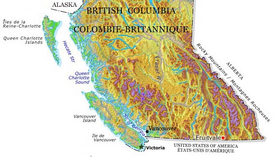
-
Article
Gagetown
Gagetown, NB, incorporated as a village in 1966, population 698 (2011c), 719 (2006c). The Village of Gagetown is situated on Gagetown Creek, adjacent to the SAINT JOHN RIVER and opposite the mouth of the Jemseg River.
"https://development.thecanadianencyclopedia.ca/images/tce_placeholder.jpg?v=e9dca980c9bdb3aa11e832e7ea94f5d9" // resources/views/front/categories/view.blade.php
https://development.thecanadianencyclopedia.ca/images/tce_placeholder.jpg?v=e9dca980c9bdb3aa11e832e7ea94f5d9
-
"https://d2ttikhf7xbzbs.cloudfront.net/1200px-Old_Post_Office_Galt_Cambridge_Ontario.jpg" // resources/views/front/categories/view.blade.php
https://d2ttikhf7xbzbs.cloudfront.net/1200px-Old_Post_Office_Galt_Cambridge_Ontario.jpg
-
Article
Garson
Garson, Manitoba, unincorporated village, population 483 (2011c), 324 (2006c). Garson was incorporated as the Village of Lyall in 1915 and amalgamated into the Rural Municipality of Brokenhead in 2003. The community is located 37 km northeast of Winnipeg.
"https://development.thecanadianencyclopedia.ca/images/tce_placeholder.jpg?v=e9dca980c9bdb3aa11e832e7ea94f5d9" // resources/views/front/categories/view.blade.php
https://development.thecanadianencyclopedia.ca/images/tce_placeholder.jpg?v=e9dca980c9bdb3aa11e832e7ea94f5d9
-
Article
Grandview
Grandview, Manitoba, incorporated as a village in 1906 and as a town in 1909, population 859 (2011c), 839 (2006c). The Town of Grandview nestles between Riding and Duck mountains on the Valley River, 360 km northwest of Winnipeg.
"https://development.thecanadianencyclopedia.ca/images/tce_placeholder.jpg?v=e9dca980c9bdb3aa11e832e7ea94f5d9" // resources/views/front/categories/view.blade.php
https://development.thecanadianencyclopedia.ca/images/tce_placeholder.jpg?v=e9dca980c9bdb3aa11e832e7ea94f5d9
-
Article
Granisle
Granisle, BC, incorporated as a village in 1971, population 303 (2011c), 364 (2006c). The Village of Granisle is located in central British Columbia on the west shore of Babine Lake, the longest natural lake in the province (at 177 km).
"https://development.thecanadianencyclopedia.ca/images/tce_placeholder.jpg?v=e9dca980c9bdb3aa11e832e7ea94f5d9" // resources/views/front/categories/view.blade.php
https://development.thecanadianencyclopedia.ca/images/tce_placeholder.jpg?v=e9dca980c9bdb3aa11e832e7ea94f5d9
-
Article
Grise Fiord
Grise Fiord, Nunavut, incorporated as a hamlet in 1987, population 130 (2011c), 141 (2006c). The Hamlet of Grise Fiord is located on the south coast of ELLESMERE ISLAND.
"https://d2ttikhf7xbzbs.cloudfront.net/media/media/81bcc22e-e2e4-4910-bb40-41c34dc9ce59.jpg" // resources/views/front/categories/view.blade.php
https://d2ttikhf7xbzbs.cloudfront.net/media/media/81bcc22e-e2e4-4910-bb40-41c34dc9ce59.jpg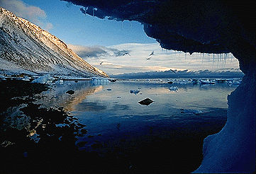
-
Article
Haines Junction
Haines Junction, Yukon, incorporated as a village in 1984, population 688 (2021 census), 613 (2016 census). The Village of Haines Junction is located in the Shakwak Valley of southwestern Yukon at the junction of the Haines and Alaska highways. With Kluane National Park and Reserve lying to the west, the village is the park's headquarters and offers a range of recreational activities, including trail riding and guided tours.
"https://d2ttikhf7xbzbs.cloudfront.net/hainesjunction/haines-junction-sunrise.jpg" // resources/views/front/categories/view.blade.php
https://d2ttikhf7xbzbs.cloudfront.net/hainesjunction/haines-junction-sunrise.jpg
-
Article
Sanirajak
Sanirajak, Nunavut, incorporated as a hamlet in 1978, population 891 (2021 census), 848 (2016 census). Sanirajak, previously known as Hall Beach, is located on the east shore of the Melville Peninsula.
"https://development.thecanadianencyclopedia.ca/images/tce_placeholder.jpg?v=e9dca980c9bdb3aa11e832e7ea94f5d9" // resources/views/front/categories/view.blade.php
https://development.thecanadianencyclopedia.ca/images/tce_placeholder.jpg?v=e9dca980c9bdb3aa11e832e7ea94f5d9
-
Article
Hazelton
Hazelton, British Columbia, incorporated as a village in 1956, population 270 (2011c), 293 (2006c). The Village of Hazelton is situated at the confluence of the Skeena and Bulkley rivers. The townsite was laid out by Edgar DEWDNEY in 1871 next to the GITKSAN village of Gitanmaax.
"https://development.thecanadianencyclopedia.ca/images/tce_placeholder.jpg?v=e9dca980c9bdb3aa11e832e7ea94f5d9" // resources/views/front/categories/view.blade.php
https://development.thecanadianencyclopedia.ca/images/tce_placeholder.jpg?v=e9dca980c9bdb3aa11e832e7ea94f5d9
-
Article
High Prairie
High Prairie, Alta, incorporated as a village in 1945 and as a town in 1950, population 2600 (2011c), 2785 (2006c). Located on the south edge of the Peace River region, the Town of High Prairie is 365 km northwest of Edmonton and 200 km northeast of Grande Prairie.
"https://d2ttikhf7xbzbs.cloudfront.net/media/media/430178ab-66e7-4f64-a004-dcce0b8ac820.jpg" // resources/views/front/categories/view.blade.php
https://d2ttikhf7xbzbs.cloudfront.net/media/media/430178ab-66e7-4f64-a004-dcce0b8ac820.jpg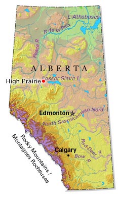
-
Article
Igloolik
Igloolik, Nunavut, incorporated as a hamlet in 1976, population 1454 (2011c), 1538 (2006c). The Hamlet of Igloolik is located on an island of the same name at the eastern entrance to FURY AND HECLA STRAIT, off the coast of the MELVILLE PENINSULA.
"https://d2ttikhf7xbzbs.cloudfront.net/media/media/75e593e0-0331-436c-92db-8ff4782a8e02.jpg" // resources/views/front/categories/view.blade.php
https://d2ttikhf7xbzbs.cloudfront.net/media/media/75e593e0-0331-436c-92db-8ff4782a8e02.jpg
-
Article
Kamouraska (Qué)
In 1849 the first superior court outside Québec City was established here. Incorporated as a village in 1858, Kamouraska was an important tourist area in the 19th and early 20th centuries. People came to admire the countryside, breathe the salt air and bathe in the sea.
"https://d2ttikhf7xbzbs.cloudfront.net/media/media/807c11be-1891-494f-a926-99f1c1ccd160.jpg" // resources/views/front/categories/view.blade.php
https://d2ttikhf7xbzbs.cloudfront.net/media/media/807c11be-1891-494f-a926-99f1c1ccd160.jpg