Browse "Cities & Populated Places"
-
Article
Témiscaming
Témiscaming, Quebec, incorporated as a town in 1988, population 2,368 (2021 census), 2,431 (2016 census). Témiscaming is located at the southern end of Lac Témiscamingue (spelled Timiskaming in Ontario) near the rapids that link the lake with the Ottawa River. In 1888, a sawmill was built nearby.
"https://development.thecanadianencyclopedia.ca/images/tce_placeholder.jpg?v=e9dca980c9bdb3aa11e832e7ea94f5d9" // resources/views/front/categories/view.blade.php
https://development.thecanadianencyclopedia.ca/images/tce_placeholder.jpg?v=e9dca980c9bdb3aa11e832e7ea94f5d9
-
Article
Terrace
Terrace, BC, incorporated as a city in 1987, population 11 486 (2011c), 11 320 (2006c).
"https://development.thecanadianencyclopedia.ca/images/tce_placeholder.jpg?v=e9dca980c9bdb3aa11e832e7ea94f5d9" // resources/views/front/categories/view.blade.php
https://development.thecanadianencyclopedia.ca/images/tce_placeholder.jpg?v=e9dca980c9bdb3aa11e832e7ea94f5d9
-
Article
Terrebonne
Vieux Terrebonne is a veritable heritage storehouse. The historic buildings and landmarks of the old village centre recall the role played by the NORTH WEST COMPANY in the history of Terrebonne.
"https://development.thecanadianencyclopedia.ca/images/tce_placeholder.jpg?v=e9dca980c9bdb3aa11e832e7ea94f5d9" // resources/views/front/categories/view.blade.php
https://development.thecanadianencyclopedia.ca/images/tce_placeholder.jpg?v=e9dca980c9bdb3aa11e832e7ea94f5d9
-
Article
Teslin
Teslin, Yukon, incorporated as a village in 1984, population 124 (2016 census), 122 (2011 census). The village of Teslin is located on Teslin Lake at the mouth of the Nisutlin River. It is on the Alaska Highway, 183 km by road southeast of Whitehorse.
"https://development.thecanadianencyclopedia.ca/images/tce_placeholder.jpg?v=e9dca980c9bdb3aa11e832e7ea94f5d9" // resources/views/front/categories/view.blade.php
https://development.thecanadianencyclopedia.ca/images/tce_placeholder.jpg?v=e9dca980c9bdb3aa11e832e7ea94f5d9
-
Article
The Forks
The Forks is a public space where the Red and Assiniboine rivers meet in the heart of what is now the city of Winnipeg, Manitoba. It occupies the waterfront zone east of Main Street and south of the CN mainline rail bridge. The Forks has played a complex role in the history of the region and of Canada as a whole. It has been a traditional gathering place for thousands of years and was an important hub of the fur trade in the 18th and 19th centuries. In the late 19th and early 20th centuries, many immigrants stopped at the Forks on their journey west. It was designated a National Historic Site of Canada in 1974 and is home to other sites of historical and archeological significance, as well as museums, monuments, parks and theatres.
"https://d2ttikhf7xbzbs.cloudfront.net/media/media/f41c3a13-720f-45c4-ac85-d43341093acf.jpg" // resources/views/front/categories/view.blade.php
https://d2ttikhf7xbzbs.cloudfront.net/media/media/f41c3a13-720f-45c4-ac85-d43341093acf.jpg
-
Article
The Pas
The Pas, Manitoba, incorporated as a town in 1912, population 5,639 (2021 census), 5,369 (2016 census). The town of The Pas is located on the south bank of the Saskatchewan River, about 60 km northwest of where the river enters Cedar Lake.
"https://development.thecanadianencyclopedia.ca/images/tce_placeholder.jpg?v=e9dca980c9bdb3aa11e832e7ea94f5d9" // resources/views/front/categories/view.blade.php
https://development.thecanadianencyclopedia.ca/images/tce_placeholder.jpg?v=e9dca980c9bdb3aa11e832e7ea94f5d9
-
Article
Thetford Mines
Thetford Mines, Quebec, incorporated as a city in 1905, population 26,072 (2021 census), population 25,403 (2016 census). The city of Thetford Mines is located on the Bécancour River in the Appalachian Mountains, 107 km south of Quebec City. It was named after the town of Thetford in Norfolk, England. During the 20th century, it was one of the world’s largest asbestos mining and production centres.
"https://d2ttikhf7xbzbs.cloudfront.net/media/new_article_images/ThetfordMines/ThetfordMines.jpg" // resources/views/front/categories/view.blade.php
https://d2ttikhf7xbzbs.cloudfront.net/media/new_article_images/ThetfordMines/ThetfordMines.jpg
-
Article
Thompson
Thompson, Manitoba, incorporated as a city in 1970, population 12 829 (2011c), 13 446 (2006c). The City of Thompson is located on the south side of the Burntwood River, 740 km north of Winnipeg.
"https://d2ttikhf7xbzbs.cloudfront.net/media/media/47481ba8-856b-414e-a45d-175e7b331f81.jpg" // resources/views/front/categories/view.blade.php
https://d2ttikhf7xbzbs.cloudfront.net/media/media/47481ba8-856b-414e-a45d-175e7b331f81.jpg
-
Article
Thorold
Thorold, Ont, incorporated as a city in 1975, population 17 931 (2011c), 18 224 (2006c). The City of Thorold is situated on the NIAGARA PENINSULA. Though physically linked to ST CATHARINES, its large neighbour directly to the
"https://development.thecanadianencyclopedia.ca/images/tce_placeholder.jpg?v=e9dca980c9bdb3aa11e832e7ea94f5d9" // resources/views/front/categories/view.blade.php
https://development.thecanadianencyclopedia.ca/images/tce_placeholder.jpg?v=e9dca980c9bdb3aa11e832e7ea94f5d9
-
Article
Three Hills
Three Hills, Alta, incorporated as a town in 1929, population 3198 (2011c), 3089 (2006c). The Town of Three Hills is located 128 km northeast of Calgary. Three Hills takes its name from 3 prominent hills to the north of the town.
"https://d2ttikhf7xbzbs.cloudfront.net/media/media/5ecb9aa6-e6d7-420b-a068-c8a30e4d9c1c.jpg" // resources/views/front/categories/view.blade.php
https://d2ttikhf7xbzbs.cloudfront.net/media/media/5ecb9aa6-e6d7-420b-a068-c8a30e4d9c1c.jpg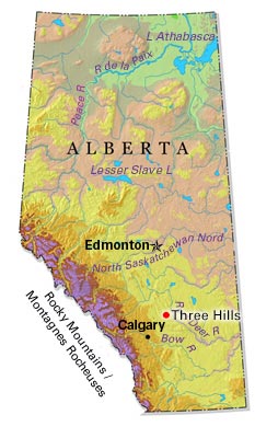
-
Article
Thunder Bay
Thunder Bay, ON, incorporated as a city in 1970, population 108,843 (2021 census), 107,909 (2016 census). The City of Thunder Bay was created by the amalgamation of the cities of Fort William and Port Arthur and the townships of Neebing and McIntyre. It is located in northwestern Ontario on the west shore of the Lake Superior bay of the same name. Thunder Bay is situated on the traditional territory of the Anishinaabeg, and the land is covered by the Robinson-Superior Treaty. The Port of Thunder Bay is a western stop along the Great Lakes-St Lawrence Seaway. The region’s geography is dominated by the rocks, lakes and forests of the Canadian Shield. Surrounding communities depend on tourism or resource extraction and look to Thunder Bay for a wide variety of services.
"https://d2ttikhf7xbzbs.cloudfront.net/media/new_article_images/ThunderBay/12171019064_8ca50f0bb8_z.jpg" // resources/views/front/categories/view.blade.php
https://d2ttikhf7xbzbs.cloudfront.net/media/new_article_images/ThunderBay/12171019064_8ca50f0bb8_z.jpg
-
Article
Tignish
Today, Tignish is 93% Roman Catholic and more than 20% of the population can speak both French and English. The co-operative movement has been one of the community's most distinctive features.
"https://development.thecanadianencyclopedia.ca/images/tce_placeholder.jpg?v=e9dca980c9bdb3aa11e832e7ea94f5d9" // resources/views/front/categories/view.blade.php
https://development.thecanadianencyclopedia.ca/images/tce_placeholder.jpg?v=e9dca980c9bdb3aa11e832e7ea94f5d9
-
Article
Tilbury
Tilbury, Ont, urban area, population 4700 (2011c), 4809 (2006c). Tilbury is located 56 km east of WINDSOR. It was a town from 1910 to 1998, when it was amalgamated with the new municipality of CHATHAM-KENT.
"https://development.thecanadianencyclopedia.ca/images/tce_placeholder.jpg?v=e9dca980c9bdb3aa11e832e7ea94f5d9" // resources/views/front/categories/view.blade.php
https://development.thecanadianencyclopedia.ca/images/tce_placeholder.jpg?v=e9dca980c9bdb3aa11e832e7ea94f5d9
-
Article
Tillsonburg
Tillsonburg, Ont, incorporated as a town in 1872, population 15 301 (2011c), 14 822 (2006c). The Town of Tillsonburg is located in Oxford County, 40 km east of ST THOMAS. Founder George Tillson arrived in 1825 and opened a forge
"https://development.thecanadianencyclopedia.ca/images/tce_placeholder.jpg?v=e9dca980c9bdb3aa11e832e7ea94f5d9" // resources/views/front/categories/view.blade.php
https://development.thecanadianencyclopedia.ca/images/tce_placeholder.jpg?v=e9dca980c9bdb3aa11e832e7ea94f5d9
-
Article
Timmins
Timmins, Ontario, incorporated as a city in 1973, population 41,145 (2021 census), 41,788 (2016 census). The city of Timmins is located 290 km northwest of Greater Sudbury.
"https://d2ttikhf7xbzbs.cloudfront.net/media/media/77a2b646-1dd7-44c2-8094-136b666d627e.jpg" // resources/views/front/categories/view.blade.php
https://d2ttikhf7xbzbs.cloudfront.net/media/media/77a2b646-1dd7-44c2-8094-136b666d627e.jpg