Browse "Regions"
-
Article
James Bay
James Bay is the southern appendage of Hudson Bay. It is about 160 km wide between Pointe Louis-XIV on the east coast and Cape Henrietta Marie on the west.
"https://development.thecanadianencyclopedia.ca/images/tce_placeholder.jpg?v=e9dca980c9bdb3aa11e832e7ea94f5d9" // resources/views/front/categories/view.blade.php
https://development.thecanadianencyclopedia.ca/images/tce_placeholder.jpg?v=e9dca980c9bdb3aa11e832e7ea94f5d9
-
Article
Labrador Highlands
Formed of ancient Precambrian rocks and heavily glaciated during the Quaternary (1.65 million to 10 000 years ago), the mountains support more than 70 small glaciers, the southernmost in eastern North America.
"https://development.thecanadianencyclopedia.ca/images/tce_placeholder.jpg?v=e9dca980c9bdb3aa11e832e7ea94f5d9" // resources/views/front/categories/view.blade.php
https://development.thecanadianencyclopedia.ca/images/tce_placeholder.jpg?v=e9dca980c9bdb3aa11e832e7ea94f5d9
-
"https://development.thecanadianencyclopedia.ca/images/tce_placeholder.jpg?v=e9dca980c9bdb3aa11e832e7ea94f5d9" // resources/views/front/categories/view.blade.php
https://development.thecanadianencyclopedia.ca/images/tce_placeholder.jpg?v=e9dca980c9bdb3aa11e832e7ea94f5d9
-
Article
Laurentian Highlands
Although the other limits are less well defined, the highlands may be considered to extend 100-200 km northward from the scarps and to stretch from the Gatineau River in the west (mean elevation 400 m) some 550 km to the SAGUENAY RIVER in the northeast.
"https://d2ttikhf7xbzbs.cloudfront.net/media/media/081947b9-bef7-47f0-b7c2-f8dbb47f7f9a.jpg" // resources/views/front/categories/view.blade.php
https://d2ttikhf7xbzbs.cloudfront.net/media/media/081947b9-bef7-47f0-b7c2-f8dbb47f7f9a.jpg
-
Article
Moon
The dark grey lunar surface reflects only 7% of the sunlight it receives (comparable to the reflectivity of black soil). The moon is dominated by thousands of craters, ranging from microscopic pits to gigantic Clavius, diameter 230 km.
"https://d2ttikhf7xbzbs.cloudfront.net/media/media/4bc37824-aa84-4a84-9b3c-b620f26bc350.jpg" // resources/views/front/categories/view.blade.php
https://d2ttikhf7xbzbs.cloudfront.net/media/media/4bc37824-aa84-4a84-9b3c-b620f26bc350.jpg
-
Article
Muskeg
Muskeg (from Cree maskek and Ojibwe mashkiig, meaning “grassy bog”) is a type of northern landscape characterized by a wet environment, vegetation and peat deposits. Chiefly used in North America, the term muskeg escapes precise scientific definition. It encompasses various types of wetlands found in the boreal zone, including bogs, fens, swamps and mires. In Canada, muskeg and other peatlands cover up to 1.2 million km2, or 12 per cent of the country’s surface.
"https://d2ttikhf7xbzbs.cloudfront.net/media/new_article_images/Muskeg/Muskeg 1.jpg" // resources/views/front/categories/view.blade.php
https://d2ttikhf7xbzbs.cloudfront.net/media/new_article_images/Muskeg/Muskeg 1.jpg
-
Article
New Caledonia
New Caledonia ("New Scotland"), was a name given in 1806 to the central and highland plateau area of BRITISH COLUMBIA by Simon FRASER, a partner, trader and explorer in the NORTH WEST CO.
"https://development.thecanadianencyclopedia.ca/images/tce_placeholder.jpg?v=e9dca980c9bdb3aa11e832e7ea94f5d9" // resources/views/front/categories/view.blade.php
https://development.thecanadianencyclopedia.ca/images/tce_placeholder.jpg?v=e9dca980c9bdb3aa11e832e7ea94f5d9
-
Article
North
In strictly geographic terms, the North refers to the immense hinterland of Canada that lies beyond the narrow strip of the country in which most Canadians live and work, but generally refers to the Northwest Territories, the Yukon and Nunavut.
"https://d2ttikhf7xbzbs.cloudfront.net/media/media/02e4d1f2-17fa-4305-8972-b3b6b9d152fb.jpg" // resources/views/front/categories/view.blade.php
https://d2ttikhf7xbzbs.cloudfront.net/media/media/02e4d1f2-17fa-4305-8972-b3b6b9d152fb.jpg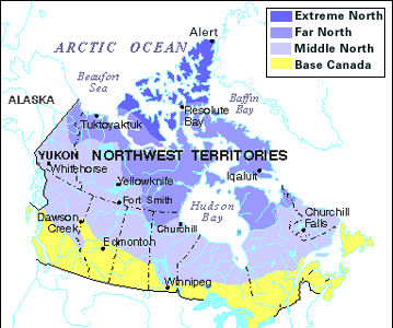
-
Article
Okanagan Valley
The Okanagan Valley is in south-central British Columbia, extending about 200 km north from the American border.
"https://d2ttikhf7xbzbs.cloudfront.net/media/media/4c55a3e5-810a-4ea3-b81d-24da77ff3b7c.jpg" // resources/views/front/categories/view.blade.php
https://d2ttikhf7xbzbs.cloudfront.net/media/media/4c55a3e5-810a-4ea3-b81d-24da77ff3b7c.jpg
-
Article
Old Crow Basin
Old Crow Basin is an important geographic feature in the natural history and human history of Canada
"https://d2ttikhf7xbzbs.cloudfront.net/media/media/3372115f-2e5f-492c-a1d9-de73d4668939.jpg" // resources/views/front/categories/view.blade.php
https://d2ttikhf7xbzbs.cloudfront.net/media/media/3372115f-2e5f-492c-a1d9-de73d4668939.jpg
-
Article
Old Crow Plain
The vegetation is of the tundra type, with outliers of the boreal spruce forest; willow thickets line the course of the Old Crow River.
"https://d2ttikhf7xbzbs.cloudfront.net/media/media/3372115f-2e5f-492c-a1d9-de73d4668939.jpg" // resources/views/front/categories/view.blade.php
https://d2ttikhf7xbzbs.cloudfront.net/media/media/3372115f-2e5f-492c-a1d9-de73d4668939.jpg
-
Article
Peace River Lowland
The Peace River Lowland is a gently rolling lowland without clearly defined outer boundaries, extending east of the Rocky Mountains on both sides of the Peace River, sloping downward to the north and east.
"https://d2ttikhf7xbzbs.cloudfront.net/media/media/13c13382-db21-45b1-a110-45d06d282f6e.jpg" // resources/views/front/categories/view.blade.php
https://d2ttikhf7xbzbs.cloudfront.net/media/media/13c13382-db21-45b1-a110-45d06d282f6e.jpg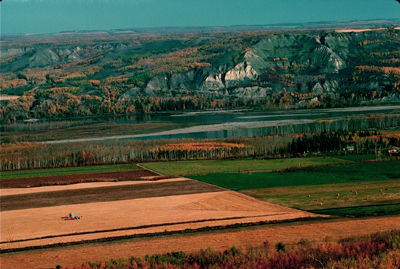
-
Article
Rocky Mountain Trench
The Rocky Mountain Trench is a long and deep valley extending approximately 1,500 km from the Bitterroot Valley in northwest Montana through British Columbia to the Liard Plain just south of the Yukon Territory. Its predominantly flat floor is 3–20 km wide and ranges in elevation between 600 m and 1,000 m above sea level. With walls made of sedimentary, volcanic and igneous rock, the Trench is sometimes referred to as the “Valley of a Thousand Peaks” because of the towering mountain ranges on either side: the Rocky Mountains to the east and the Columbia, Omineca and Cassiar mountains to the west. Humans have relied on the rich resources provided by this distinctive landscape from pre-colonial times to the present.
"https://d2ttikhf7xbzbs.cloudfront.net/media/media/061fe992-a3bf-45bc-906d-216d1bef45c7.jpg" // resources/views/front/categories/view.blade.php
https://d2ttikhf7xbzbs.cloudfront.net/media/media/061fe992-a3bf-45bc-906d-216d1bef45c7.jpg
-
Article
St. Lawrence Lowland
St. Lawrence Lowland is a plain along the St. Lawrence River between Québec City in the east and Brockville, Ontario, in the west, including the Ottawa River valley west to Renfrew, Ontario.
"https://development.thecanadianencyclopedia.ca/images/tce_placeholder.jpg?v=e9dca980c9bdb3aa11e832e7ea94f5d9" // resources/views/front/categories/view.blade.php
https://development.thecanadianencyclopedia.ca/images/tce_placeholder.jpg?v=e9dca980c9bdb3aa11e832e7ea94f5d9
-
Article
Thousand Islands
Thousand Islands (Ontario part), an 80 km long section of the St Lawrence River, extending downstream from Lake Ontario between Kingston and Brockville and containing over 1000 rocky, wooded islands which range from several square kilometres to barely emergent rocks and shoals.
"https://development.thecanadianencyclopedia.ca/images/tce_placeholder.jpg?v=e9dca980c9bdb3aa11e832e7ea94f5d9" // resources/views/front/categories/view.blade.php
https://development.thecanadianencyclopedia.ca/images/tce_placeholder.jpg?v=e9dca980c9bdb3aa11e832e7ea94f5d9