Browse "Rivers"
-
Article
Rivière Eastmain
The Rivière Eastmain, 756 km long, rises in the central part of Québec on the side of a low drainage divide from which streams flow west to James Bay.
"https://development.thecanadianencyclopedia.ca/images/tce_placeholder.jpg?v=e9dca980c9bdb3aa11e832e7ea94f5d9" // resources/views/front/categories/view.blade.php
https://development.thecanadianencyclopedia.ca/images/tce_placeholder.jpg?v=e9dca980c9bdb3aa11e832e7ea94f5d9
-
Article
Rivière Koksoak
Koksoak, Rivière, 874 km long (to head of Caniapiscau River), final leg of a river system that drains a vast area (133 000 km2) of northern Québec.
"https://development.thecanadianencyclopedia.ca/images/tce_placeholder.jpg?v=e9dca980c9bdb3aa11e832e7ea94f5d9" // resources/views/front/categories/view.blade.php
https://development.thecanadianencyclopedia.ca/images/tce_placeholder.jpg?v=e9dca980c9bdb3aa11e832e7ea94f5d9
-
Article
Rivière Manicouagan
The Rivière Manicouagan, 560 km long, rises in east-central Québec near the Labrador border and flows south through the Réservoir Manicouagan to the St Lawrence River near Baie-Comeau.
"https://d2ttikhf7xbzbs.cloudfront.net/media/media/6be9c93a-1849-439f-b16a-f87c91691760.jpg" // resources/views/front/categories/view.blade.php
https://d2ttikhf7xbzbs.cloudfront.net/media/media/6be9c93a-1849-439f-b16a-f87c91691760.jpg
-
Article
Rivière Moisie
Rivière Moisie, 410 km long, rises in eastern Québec from Lac Opocopa and flows south to the St. Lawrence River. With a drainage basin of 19,200 km2 and a mean discharge of 490 m3/s, it is the river of greatest volume along the middle north Shore of the St. Lawrence.
"https://development.thecanadianencyclopedia.ca/images/tce_placeholder.jpg?v=e9dca980c9bdb3aa11e832e7ea94f5d9" // resources/views/front/categories/view.blade.php
https://development.thecanadianencyclopedia.ca/images/tce_placeholder.jpg?v=e9dca980c9bdb3aa11e832e7ea94f5d9
-
Article
Rivière Nottaway
Rivière Nottaway, 776 km (via Rivière Bell to head of Rivière Mégiscane), rises in west-central Québec and flows north via Lacs Parent and Quévillon into Lac Matagami. Here it is joined by its chief headstream, Rivière Waswanipi, and then drains northwest through Lac Soscumica.
"https://development.thecanadianencyclopedia.ca/images/tce_placeholder.jpg?v=e9dca980c9bdb3aa11e832e7ea94f5d9" // resources/views/front/categories/view.blade.php
https://development.thecanadianencyclopedia.ca/images/tce_placeholder.jpg?v=e9dca980c9bdb3aa11e832e7ea94f5d9
-
Article
Rivière Richelieu
The Richelieu River has played a prominent role in the historical development of Québec. Originally inhabited by Iroquois, Huron and Algonquin, Samuel de CHAMPLAIN navigated its waters shortly after his arrival in 1608.
"https://d2ttikhf7xbzbs.cloudfront.net/media/media/eb8d4d81-eea3-4fe3-b07d-149f6170ebbf.jpg" // resources/views/front/categories/view.blade.php
https://d2ttikhf7xbzbs.cloudfront.net/media/media/eb8d4d81-eea3-4fe3-b07d-149f6170ebbf.jpg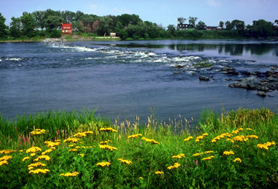
-
Article
Rivière Romaine
Rivière Romaine, 496 km long with a 14 350 km2 basin, rises (elev 760 m) in the Québec-Labrador lacustrine plateau, 45 km southwest of the CHURCHILL RIVER, and forms part of the Québec-Labrador boundary north of the 52nd parallel.
"https://development.thecanadianencyclopedia.ca/images/tce_placeholder.jpg?v=e9dca980c9bdb3aa11e832e7ea94f5d9" // resources/views/front/categories/view.blade.php
https://development.thecanadianencyclopedia.ca/images/tce_placeholder.jpg?v=e9dca980c9bdb3aa11e832e7ea94f5d9
-
Article
Rouge River (Québec)
The Rouge River is a tributary of the Ottawa River. Its source is Lac de la Fougère, in the northeast part of Rouge-Matawin Wildlife Reserve in Québec.
"https://d2ttikhf7xbzbs.cloudfront.net/media/media/6953ea93-69d2-40dd-a80d-f44f0be8c655.JPG" // resources/views/front/categories/view.blade.php
https://d2ttikhf7xbzbs.cloudfront.net/media/media/6953ea93-69d2-40dd-a80d-f44f0be8c655.JPG
-
Article
Rivière Saint-François
Rivière Saint-François, 280 km long, drainage basin 10 230 km2, is located in southern Québec.
"https://development.thecanadianencyclopedia.ca/images/tce_placeholder.jpg?v=e9dca980c9bdb3aa11e832e7ea94f5d9" // resources/views/front/categories/view.blade.php
https://development.thecanadianencyclopedia.ca/images/tce_placeholder.jpg?v=e9dca980c9bdb3aa11e832e7ea94f5d9
-
Article
Rivière Saint-Maurice
Rivière Saint-Maurice, 563 km long, rises upstream from Réservoir Gouin, 200 km west of Lac Saint-Jean, Québec. It drains a basin of 43 300 km2. After its confluence with Rivière Manouane, it feeds Réservoir Blanc and then takes in the Vermillon, Trenche, Croche, Mattawin and Mékinac rivers.
"https://d2ttikhf7xbzbs.cloudfront.net/media/media/26ddf9e4-78b9-4850-b1ab-94971048ce2e.jpg" // resources/views/front/categories/view.blade.php
https://d2ttikhf7xbzbs.cloudfront.net/media/media/26ddf9e4-78b9-4850-b1ab-94971048ce2e.jpg
-
Article
Saguenay River
The Saguenay River, approximately 170 km long, issues from Lac Saint-Jean in the Laurentian Highlands of Quebec. It has a drainage basin of 88,000 km2 and a mean discharge of 1,750 m3/s. It discharges from the lake through two channels, which join some 10 km from the lake near Alma.
"https://d2ttikhf7xbzbs.cloudfront.net/media/media/a2c21ed3-15d9-49da-a892-5c898eeba2d4.jpg" // resources/views/front/categories/view.blade.php
https://d2ttikhf7xbzbs.cloudfront.net/media/media/a2c21ed3-15d9-49da-a892-5c898eeba2d4.jpg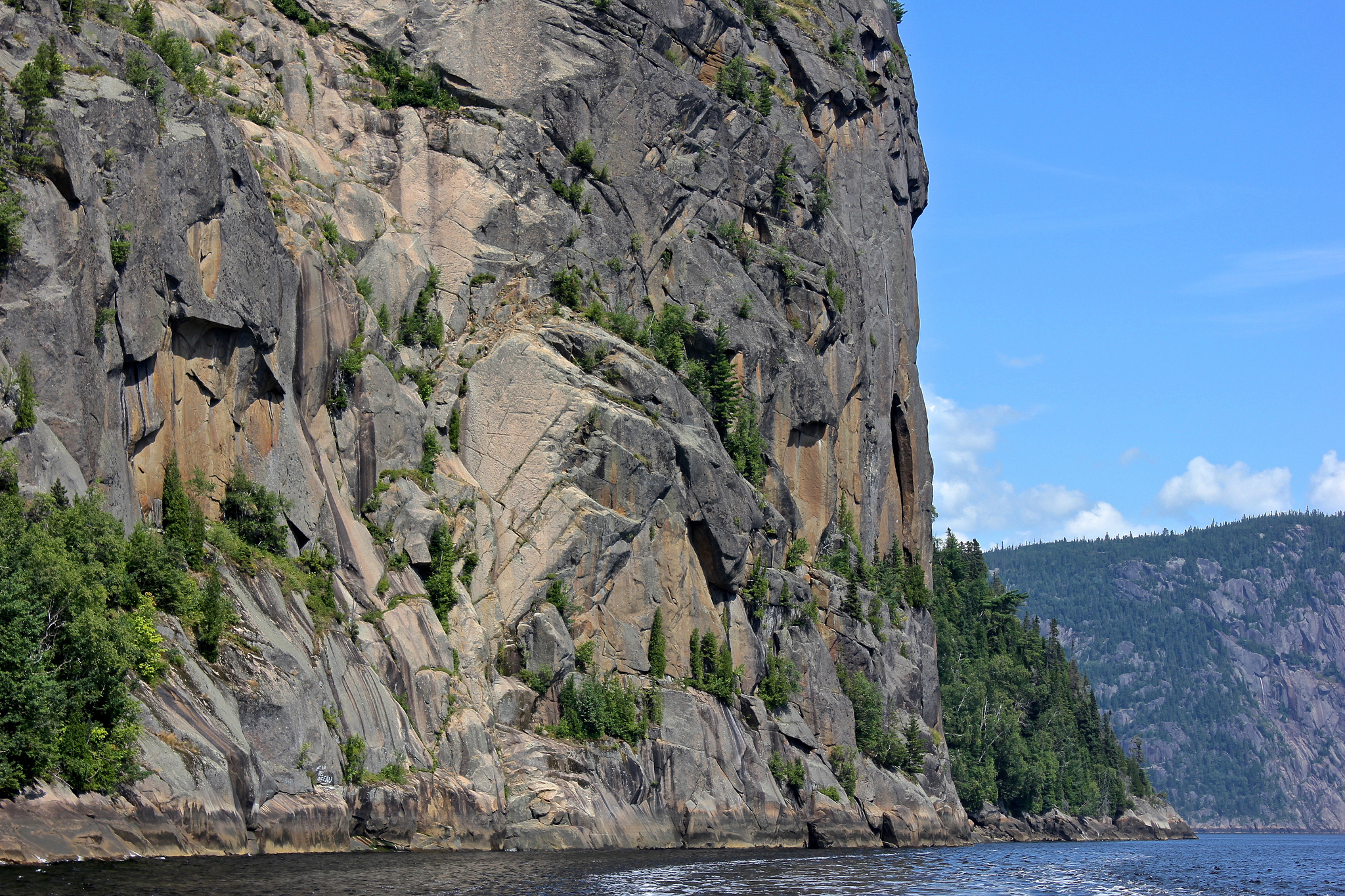
-
Article
Saint John River
Saint John River, 673 km long, rises in northern Maine and flows northeast into the forests of Madawaska County to Edmundston, where it is joined by the Madawaska River and turns southeast, forming much of the border between Maine and New Brunswick. Saint John River is known as the Wolastoq by the Wolastoqiyik people, which means “beautiful river” in their language.
"https://d2ttikhf7xbzbs.cloudfront.net/media/media/150b0699-4963-43be-ada6-fe736bf4d819.jpg" // resources/views/front/categories/view.blade.php
https://d2ttikhf7xbzbs.cloudfront.net/media/media/150b0699-4963-43be-ada6-fe736bf4d819.jpg
-
Article
Saskatchewan River
The Saskatchewan River is 1,939 km long from the Rocky Mountains headwaters to Cedar Lake in central Manitoba. When including its longest tributary, the South Saskatchewan River, the Saskatchewan River is the fourth-longest river in Canada. It’s a major tributary to the Nelson River, ultimately draining into Hudson Bay. Its name is derived from the Cree word kisiskâciwanisîpiy meaning swift-flowing river. The Saskatchewan River was a major transportation route for First Nations for thousands of years and was an instrumental transportation and resource corridor during the fur trade and early European exploration.
"https://d2ttikhf7xbzbs.cloudfront.net/media/media/93fd98fe-c2c2-469c-8d71-3bd19c6e7b52.png" // resources/views/front/categories/view.blade.php
https://d2ttikhf7xbzbs.cloudfront.net/media/media/93fd98fe-c2c2-469c-8d71-3bd19c6e7b52.png
-
Article
Seal River
Named for the harbour seals (normally marine creatures) that are found up to 200 km upstream from Hudson Bay, Manitoba's Seal River is formed by the confluence of the North Seal (about 200 km long) and the South Seal (about 240 km long) rivers at Shethanei Lake.
"https://development.thecanadianencyclopedia.ca/images/tce_placeholder.jpg?v=e9dca980c9bdb3aa11e832e7ea94f5d9" // resources/views/front/categories/view.blade.php
https://development.thecanadianencyclopedia.ca/images/tce_placeholder.jpg?v=e9dca980c9bdb3aa11e832e7ea94f5d9
-
Article
Severn River
Severn River, 982 km long, rises in the wooded Shield country of northwestern Ontario and flows northeast through Severn Lake to Hudson Bay.
"https://development.thecanadianencyclopedia.ca/images/tce_placeholder.jpg?v=e9dca980c9bdb3aa11e832e7ea94f5d9" // resources/views/front/categories/view.blade.php
https://development.thecanadianencyclopedia.ca/images/tce_placeholder.jpg?v=e9dca980c9bdb3aa11e832e7ea94f5d9