Browse "Geographical features"
-
Article
Niagara Peninsula
The Niagara Peninsula lies between Lake Ontario, Lake Erie and the Niagara River in southwestern Ontario. As the river is on the international boundary between Canada and the United States, the peninsula has played a frontier role since 1783.
"https://d2ttikhf7xbzbs.cloudfront.net/media/media/11b0547f-e280-4329-9558-48e0948dc5cc.jpg" // resources/views/front/categories/view.blade.php
https://d2ttikhf7xbzbs.cloudfront.net/media/media/11b0547f-e280-4329-9558-48e0948dc5cc.jpg
-
Article
Niagara River
The Niagara River, 58 km long, issues from Lake Erie and flows north over Niagara Falls to Lake Ontario. The river’s drainage area is about 684,000 km2, and its average flow at Queenston is 5,885 m3/s. The Niagara River forms part of the border between Canada and the United States.
"https://d2ttikhf7xbzbs.cloudfront.net/media/media/c9fad2bb-2972-411a-8527-e908fa8254b6.jpg" // resources/views/front/categories/view.blade.php
https://d2ttikhf7xbzbs.cloudfront.net/media/media/c9fad2bb-2972-411a-8527-e908fa8254b6.jpg
-
Article
Nootka Sound
Nootka Sound, British Columbia, is an inlet on Vancouver Island's western coast, 270 km northwest of Victoria. This area is known for its natural beauty.
"https://d2ttikhf7xbzbs.cloudfront.net/nootkasound/Bligh-Island-Nootka-Sound.jpg" // resources/views/front/categories/view.blade.php
https://d2ttikhf7xbzbs.cloudfront.net/nootkasound/Bligh-Island-Nootka-Sound.jpg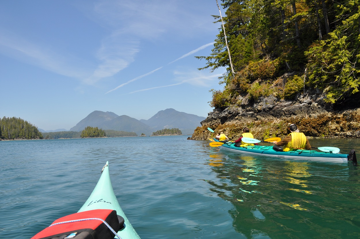
-
Article
North
In strictly geographic terms, the North refers to the immense hinterland of Canada that lies beyond the narrow strip of the country in which most Canadians live and work, but generally refers to the Northwest Territories, the Yukon and Nunavut.
"https://d2ttikhf7xbzbs.cloudfront.net/media/media/02e4d1f2-17fa-4305-8972-b3b6b9d152fb.jpg" // resources/views/front/categories/view.blade.php
https://d2ttikhf7xbzbs.cloudfront.net/media/media/02e4d1f2-17fa-4305-8972-b3b6b9d152fb.jpg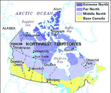
-
Article
North Cape
North Cape, also called North Port, is the northern extremity of Prince Edward Island, dividing Northumberland Strait from the Gulf of St Lawrence proper.
"https://development.thecanadianencyclopedia.ca/images/tce_placeholder.jpg?v=e9dca980c9bdb3aa11e832e7ea94f5d9" // resources/views/front/categories/view.blade.php
https://development.thecanadianencyclopedia.ca/images/tce_placeholder.jpg?v=e9dca980c9bdb3aa11e832e7ea94f5d9
-
Article
North Pole
The North Pole did not become a goal of ARCTIC EXPLORATION until fairly late; the few early expeditions that tried to reach it were looking for a polar route to the East rather than for the pole itself. W.E.
"https://d2ttikhf7xbzbs.cloudfront.net/media/media/e4d25cae-f84e-48cc-b6b7-c2b601b47f47.jpg" // resources/views/front/categories/view.blade.php
https://d2ttikhf7xbzbs.cloudfront.net/media/media/e4d25cae-f84e-48cc-b6b7-c2b601b47f47.jpg
-
Article
North Saskatchewan River
The North Saskatchewan River (1,287 km long, the first 48.5 km of which is designated as a Canadian Heritage River) is a major tributary to the Saskatchewan River, which ultimately flows into Hudson Bay. The mean annual flow is 241 m3/s; however, flow varies between the peak in July and minimum in February. It served as a major transportation route from the end of the last Ice Age through the mid-20th century.
"https://d2ttikhf7xbzbs.cloudfront.net/media/media/98d61a99-4200-4393-92c7-61a42587d6cf.jpg" // resources/views/front/categories/view.blade.php
https://d2ttikhf7xbzbs.cloudfront.net/media/media/98d61a99-4200-4393-92c7-61a42587d6cf.jpg
-
Article
Northumberland Strait
A generally shallow depth causes strong tidal currents, water turbulence and a high concentration of suspended red silt and clay, which led early French colonists to name the strait "la mer rouge.
"https://d2ttikhf7xbzbs.cloudfront.net/media/media/d2e73a66-567c-4b92-ab82-e34c1cba8a41.jpg" // resources/views/front/categories/view.blade.php
https://d2ttikhf7xbzbs.cloudfront.net/media/media/d2e73a66-567c-4b92-ab82-e34c1cba8a41.jpg
-
Article
Northwest Passage
The Northwest Passage is a sea corridor through Canada's Arctic archipelago and along the northern coast of North America. European explorers searched in vain for the passage for 300 years, intent on finding a commercially viable western sea route between Europe and Asia.
"https://d2ttikhf7xbzbs.cloudfront.net/media/media/acca04c0-f3cc-448d-b29a-0b7dbefd6ade.jpg" // resources/views/front/categories/view.blade.php
https://d2ttikhf7xbzbs.cloudfront.net/media/media/acca04c0-f3cc-448d-b29a-0b7dbefd6ade.jpg
-
Article
Notre Dame Bay
Notre Dame Bay, 6000 km 2 , is a large inlet of the Atlantic Ocean on the northeast coast of Newfoundland. It contains many islands and its shores are indented by numerous coves and smaller embayments. One of Newfoundland's
"https://d2ttikhf7xbzbs.cloudfront.net/media/media/12671f6f-b61d-4d19-a9f7-d6c43ef0496c.jpg" // resources/views/front/categories/view.blade.php
https://d2ttikhf7xbzbs.cloudfront.net/media/media/12671f6f-b61d-4d19-a9f7-d6c43ef0496c.jpg
-
Article
Nueltin Lake
Nueltin Lake, 2279 km2, elev 278 m, max length 144 km, is located on the border of Nunavut and northeastern Manitoba, about 660 km south of the Arctic Circle. An irregularly shaped lake, it has a heavily indented shoreline and contains numerous small islands.
"https://development.thecanadianencyclopedia.ca/images/tce_placeholder.jpg?v=e9dca980c9bdb3aa11e832e7ea94f5d9" // resources/views/front/categories/view.blade.php
https://development.thecanadianencyclopedia.ca/images/tce_placeholder.jpg?v=e9dca980c9bdb3aa11e832e7ea94f5d9
-
"https://development.thecanadianencyclopedia.ca/images/tce_placeholder.jpg?v=e9dca980c9bdb3aa11e832e7ea94f5d9" // resources/views/front/categories/view.blade.php
https://development.thecanadianencyclopedia.ca/images/tce_placeholder.jpg?v=e9dca980c9bdb3aa11e832e7ea94f5d9
-
Article
Oak Island
In 1795, 16-year-old Daniel McGinnis discovered a depression in the ground near a huge oak tree and evidence that a block and tackle had been used there. McGinnis and 2 friends dug at the site, revealing a filled-in shaft with platforms of decayed oak logs at 3 m levels.
"https://d2ttikhf7xbzbs.cloudfront.net/media/media/9479fa1e-5ac5-437b-816f-da794aa5071d.jpg" // resources/views/front/categories/view.blade.php
https://d2ttikhf7xbzbs.cloudfront.net/media/media/9479fa1e-5ac5-437b-816f-da794aa5071d.jpg
-
Article
Ocean
The interplay of these ocean waters with freshwater runoff from land creates the conditions that support large biological production on Canada's continental shelves and embayments (see COASTAL LANDFORM; DRAINAGE BASIN).
"https://d2ttikhf7xbzbs.cloudfront.net/media/media/9d5ea90e-c8e5-4042-9216-34c89d28b374.jpg" // resources/views/front/categories/view.blade.php
https://d2ttikhf7xbzbs.cloudfront.net/media/media/9d5ea90e-c8e5-4042-9216-34c89d28b374.jpg
-
Article
Okanagan Lake
Okanagan Lake is located in the southern interior of British Columbia and is the largest lake in the Okanagan Valley. Approximately 6,188 km2 of land drain into the lake, which has a total surface area of 351 km2. The lake is long and thin, measuring 120 km in length and ranging between 3 and 5 km in width. The depth of the lake is highly variable, with a mean depth of 76 m and a maximum depth of 230 m. Okanagan Lake is heavily used for recreation and is believed by some to be the home of the mythical Ogopogo creature.
"https://d2ttikhf7xbzbs.cloudfront.net/media/media/7683aa12-4190-4aca-ab28-5f9862bdad24.jpg" // resources/views/front/categories/view.blade.php
https://d2ttikhf7xbzbs.cloudfront.net/media/media/7683aa12-4190-4aca-ab28-5f9862bdad24.jpg