Browse "Places"
-
Article
Saint-Charles-sur-Richelieu
Like many places in the lower Richelieu region, Saint-Charles experienced a decline in the second half of the 19th century. Towards the end of the century, one of the village's activities was the transportation of oats to New York City for use as feed for tramway horses.
"https://development.thecanadianencyclopedia.ca/images/tce_placeholder.jpg?v=e9dca980c9bdb3aa11e832e7ea94f5d9" // resources/views/front/categories/view.blade.php
https://development.thecanadianencyclopedia.ca/images/tce_placeholder.jpg?v=e9dca980c9bdb3aa11e832e7ea94f5d9
-
Article
Saint-Constant
The early settlement of Saint-Constant dates back to the mid-18th century, even though the parish of Saint-Constant-de-la-Prairie-de-la-Magdeleine was only officially created in 1841.
"https://development.thecanadianencyclopedia.ca/images/tce_placeholder.jpg?v=e9dca980c9bdb3aa11e832e7ea94f5d9" // resources/views/front/categories/view.blade.php
https://development.thecanadianencyclopedia.ca/images/tce_placeholder.jpg?v=e9dca980c9bdb3aa11e832e7ea94f5d9
-
Article
Saint-Denis-sur-Richelieu
During the REBELLIONS OF 1837 it became a centre for the PATRIOTES who fought against and forced the retreat of Colonel Charles Gore's troops. In retaliation, the village was burned (see ST-DENIS, BATTLE OF).
"https://development.thecanadianencyclopedia.ca/images/tce_placeholder.jpg?v=e9dca980c9bdb3aa11e832e7ea94f5d9" // resources/views/front/categories/view.blade.php
https://development.thecanadianencyclopedia.ca/images/tce_placeholder.jpg?v=e9dca980c9bdb3aa11e832e7ea94f5d9
-
Article
Saint-Émile
Saint-Émile, Quebec, is a former city and a current sector of Quebec City. On 1 January 2002, the city of Saint-Émile was amalgamated into Quebec City alongside several other cities and municipalities in the region. Now, Saint-Émile identifies the sector of Quebec City which corresponds to the old city of Saint-Émile’s territory.
"https://d2ttikhf7xbzbs.cloudfront.net/media/media/2356d51d-54fe-4333-830f-9d6ab470d821.jpg" // resources/views/front/categories/view.blade.php
https://d2ttikhf7xbzbs.cloudfront.net/media/media/2356d51d-54fe-4333-830f-9d6ab470d821.jpg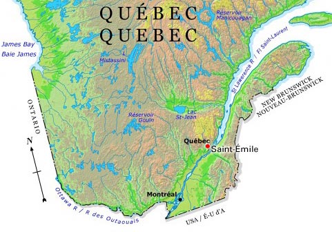
-
Article
Saint-Félicien
The town profited from the Chibougamau-Chapais mining boom of the 1950s, since nearly all the copper extracted from Chibougamau and Chapais (280 km northwest of Lac Saint-Jean) left the region via Saint-Félicien.
"https://development.thecanadianencyclopedia.ca/images/tce_placeholder.jpg?v=e9dca980c9bdb3aa11e832e7ea94f5d9" // resources/views/front/categories/view.blade.php
https://development.thecanadianencyclopedia.ca/images/tce_placeholder.jpg?v=e9dca980c9bdb3aa11e832e7ea94f5d9
-
Article
Saint-Georges
The first colonists came during the French regime to settle on seigneuries ceded to Thérèse Aubert de Lalande Gayon (Aubert-Gallion) and Gabriel Aubin de L'Isle (Aubin-de-l'Isle).
"https://development.thecanadianencyclopedia.ca/images/tce_placeholder.jpg?v=e9dca980c9bdb3aa11e832e7ea94f5d9" // resources/views/front/categories/view.blade.php
https://development.thecanadianencyclopedia.ca/images/tce_placeholder.jpg?v=e9dca980c9bdb3aa11e832e7ea94f5d9
-
Article
Saint-Honoré
Saint-Honoré, still rural in character, is best known for its flying school, Centre québécois deformation aéronautique of the CÉGEP de Chicoutimi, and for Niobec Inc, one of the world's main producers of COLUMBIUM, a mineral used in the manufacture of steel alloys.
"https://d2ttikhf7xbzbs.cloudfront.net/media/media/42288766-f783-4af8-a15d-2b97aef5f655.jpg" // resources/views/front/categories/view.blade.php
https://d2ttikhf7xbzbs.cloudfront.net/media/media/42288766-f783-4af8-a15d-2b97aef5f655.jpg
-
Article
Saint-Hyacinthe
The history of Saint-Hyacinthe began with the granting in 1748 of a seigneury which was purchased in 1753 by Hyacinthe Delorme.
"https://d2ttikhf7xbzbs.cloudfront.net/media/media/ad1f33d3-a924-44ff-90c8-787a593a06fd.jpg" // resources/views/front/categories/view.blade.php
https://d2ttikhf7xbzbs.cloudfront.net/media/media/ad1f33d3-a924-44ff-90c8-787a593a06fd.jpg
-
Article
Music in Saint-Hyacinthe
A city in Quebec on the Yamaska River, some 50 km east of Montreal. Founded in 1748, a municipality in 1849, and a town in 1857, it was named after the patron saint of Jacques-Hyacinthe-Simon Delorme, the local seigneur.
"https://development.thecanadianencyclopedia.ca/images/tce_placeholder.jpg?v=e9dca980c9bdb3aa11e832e7ea94f5d9" // resources/views/front/categories/view.blade.php
https://development.thecanadianencyclopedia.ca/images/tce_placeholder.jpg?v=e9dca980c9bdb3aa11e832e7ea94f5d9
-
Article
Saint-Isidore
Saint-Isidore, NB, incorporated as a village in 1991, population 748 (2011c), 796 (2006c). The Village of Saint-Isidore is located about 10 km inland on the northeastern tip of New Brunswick, 15 km east of TRACADIE-SHEILA.
"https://d2ttikhf7xbzbs.cloudfront.net/media/media/01b36516-3316-4622-9ac7-1426d02b2427.jpg" // resources/views/front/categories/view.blade.php
https://d2ttikhf7xbzbs.cloudfront.net/media/media/01b36516-3316-4622-9ac7-1426d02b2427.jpg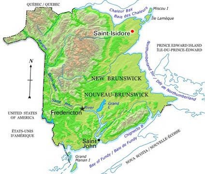
-
Article
Saint-Jean-Chrysostome
Saint-Jean-Chrysostome, Quebec, population 18,352 (2019), 17,089 (2001 census). Saint-Jean-Chrysostome is located on the south bank of the St. Lawrence River. It is some 20 km south of Quebec City in the Chaudière-Appalaches Region. This region is characterized by fertile agricultural plains, plateaus and the majestic Appalachian mountains. (See Mountain Range.) Originally incorporated in 1965, Saint-Jean-Chrysostome became part of .
"https://d2ttikhf7xbzbs.cloudfront.net/media/media/fff2605f-e1c7-4789-b999-075715b3149b.jpg" // resources/views/front/categories/view.blade.php
https://d2ttikhf7xbzbs.cloudfront.net/media/media/fff2605f-e1c7-4789-b999-075715b3149b.jpg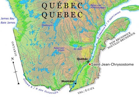
-
Article
Saint-Jean-sur-Richelieu
Saint-Jean-sur-Richelieu, Quebec, incorporated as a city in 1897, population 95,114 (2016 census), 92,394 (2011 census). The city of Saint-Jean-sur-Richelieu is located on the west bank of the upper portion of the Richelieu river, some 40 km southeast of Montreal.Saint-Jean-sur-Richelieu is located on the traditional territories of the Kanyen’kehà:ka and Abenaki. The land remains unceded and is considered Indigenous territory.
"https://d2ttikhf7xbzbs.cloudfront.net/media/single_use_images/sjsr_hôtel_de_ville.png" // resources/views/front/categories/view.blade.php
https://d2ttikhf7xbzbs.cloudfront.net/media/single_use_images/sjsr_hôtel_de_ville.png
-
Article
Saint-Jérôme
A regional metropolis situated where Rivière du Nord leaves the Laurentians, Saint-Jérôme dominates the entire Lower Laurentians. The bishopric, courthouse and CEGEP give the town an administrative function as well as industrial and commercial ones.
"https://development.thecanadianencyclopedia.ca/images/tce_placeholder.jpg?v=e9dca980c9bdb3aa11e832e7ea94f5d9" // resources/views/front/categories/view.blade.php
https://development.thecanadianencyclopedia.ca/images/tce_placeholder.jpg?v=e9dca980c9bdb3aa11e832e7ea94f5d9
-
Article
Saint John
Saint John, NB, incorporated as a city in 1785, population 69,895 (2021 census), 67,575 (2016 census). The City of Saint John, the second largest city in New Brunswick, is located at the mouth of the Saint John River on the Bay of Fundy.
"https://d2ttikhf7xbzbs.cloudfront.net/media/new_article_images/SaintJohn/8582097561_2452e069d7_z.jpg" // resources/views/front/categories/view.blade.php
https://d2ttikhf7xbzbs.cloudfront.net/media/new_article_images/SaintJohn/8582097561_2452e069d7_z.jpg
-
Article
Music in Saint John
In early Saint John, music was the special enthusiasm of the educated Loyalists and the British officers.
"https://development.thecanadianencyclopedia.ca/images/tce_placeholder.jpg?v=e9dca980c9bdb3aa11e832e7ea94f5d9" // resources/views/front/categories/view.blade.php
https://development.thecanadianencyclopedia.ca/images/tce_placeholder.jpg?v=e9dca980c9bdb3aa11e832e7ea94f5d9