Browse "Places"
-
Article
Welland
Welland, Ontario, incorporated as a city in 1917, population 52,293 (2016 census), 50,631 (2011 census). The city of Welland is located on the Niagara Peninsula, 24 km south of St. Catharines. It is named after the Welland River.
"https://development.thecanadianencyclopedia.ca/images/tce_placeholder.jpg?v=e9dca980c9bdb3aa11e832e7ea94f5d9" // resources/views/front/categories/view.blade.php
https://development.thecanadianencyclopedia.ca/images/tce_placeholder.jpg?v=e9dca980c9bdb3aa11e832e7ea94f5d9
-
Article
Welland Canal
A lifeline of trade and commerce into the heart of North America, the first Welland Canal opened in 1829, an achievement attributed primarily to a St Catharines businessman, William Hamilton MERRITT.
"https://d2ttikhf7xbzbs.cloudfront.net/media/media/84179d8e-586f-4027-a717-579ae9a9e13a.jpg" // resources/views/front/categories/view.blade.php
https://d2ttikhf7xbzbs.cloudfront.net/media/media/84179d8e-586f-4027-a717-579ae9a9e13a.jpg
-
Editorial
The Evolution of the Welland Canal
The following article is an editorial written by The Canadian Encyclopedia staff. Editorials are not usually updated.
"https://development.thecanadianencyclopedia.ca/images/tce_placeholder.jpg?v=e9dca980c9bdb3aa11e832e7ea94f5d9" // resources/views/front/categories/view.blade.php
https://development.thecanadianencyclopedia.ca/images/tce_placeholder.jpg?v=e9dca980c9bdb3aa11e832e7ea94f5d9
-
Article
Wembley
Wembley, Alta, incorporated as a village in 1928 and as a town in 1980, population 1383 (2011c), 1443 (2006c). The Town of Wembley is 23 km west of GRANDE PRAIRIE on Highway 43.
"https://d2ttikhf7xbzbs.cloudfront.net/media/media/8017676e-74f7-4386-8401-dbc6cd7dddee.jpg" // resources/views/front/categories/view.blade.php
https://d2ttikhf7xbzbs.cloudfront.net/media/media/8017676e-74f7-4386-8401-dbc6cd7dddee.jpg
-
Article
West Coast Trail
West Coast Trail, on W coast of VANCOUVER I, follows the 72 km route of the historic lifesaving trail between the communities of Bamfield and Port Renfrew, BC.
"https://development.thecanadianencyclopedia.ca/images/tce_placeholder.jpg?v=e9dca980c9bdb3aa11e832e7ea94f5d9" // resources/views/front/categories/view.blade.php
https://development.thecanadianencyclopedia.ca/images/tce_placeholder.jpg?v=e9dca980c9bdb3aa11e832e7ea94f5d9
-
Article
West Edmonton Mall
The WEM remains the largest shopping centre in North America. It was among the first shopping centres to offer a wide range of amenities, from water parks to themed streets - attractive at any time of year but particularly during winter.
"https://d2ttikhf7xbzbs.cloudfront.net/media/media/8e1f10ac-8e39-4565-bdbc-70eba80e243a.jpg" // resources/views/front/categories/view.blade.php
https://d2ttikhf7xbzbs.cloudfront.net/media/media/8e1f10ac-8e39-4565-bdbc-70eba80e243a.jpg
-
Article
West Island
The West Island is an informal name that has come to define the largely suburban western third of the Island of Montreal. Through suburbanization, the area shares a common history, culture and identity with the city of Montreal. However, because some of the West Island’s constituent communities developed separately from Montreal and because much of the Anglophone community of Quebec is now concentrated in the West Island, the area is politically, culturally and socially distinct from the rest of Greater Montreal and Quebec in general. The West Island is predominantly composed of bedroom suburbs developed in the middle decades of the 20th century. It also features large industrial sectors, Montreal’s international airport, large nature parks and several unique institutions, including the Macdonald agricultural college of McGill University.
"https://d2ttikhf7xbzbs.cloudfront.net/westisland/Baie-D-urfe.jpg" // resources/views/front/categories/view.blade.php
https://d2ttikhf7xbzbs.cloudfront.net/westisland/Baie-D-urfe.jpg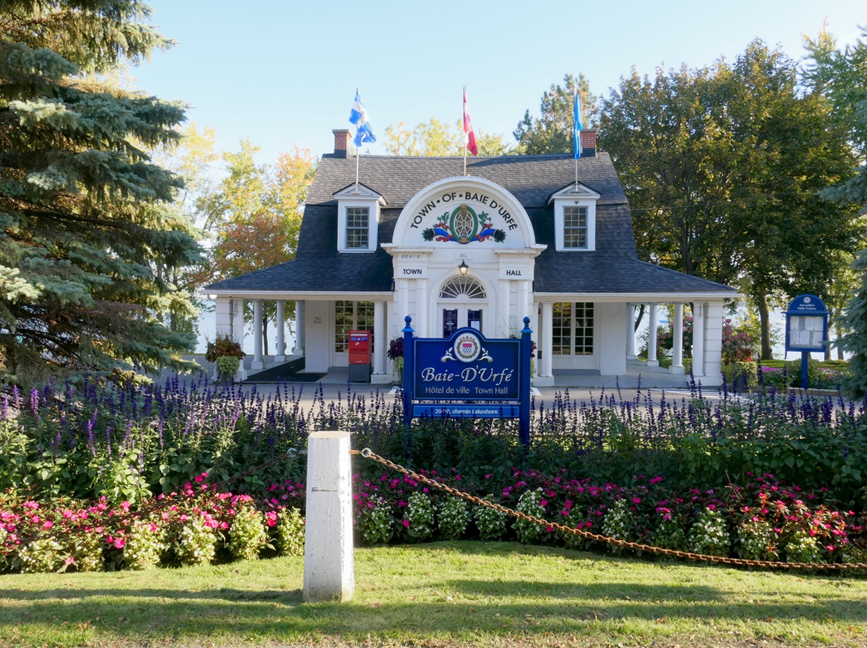
-
Article
West Nipissing
West Nipissing (also Nipissing Ouest), Ontario, incorporated as a municipality in 1999, population 14,364 (2016 census), 14,149 (2011 census). The name West Nipissing reflects the municipality's location on the northwest end of Lake Nipissing, 37 km west of North Bay. The region has a rich francophone history, and approximately 60 per cent of the population (8710 people) speak French as a mother tongue language (see Francophones of Ontario).
"https://d2ttikhf7xbzbs.cloudfront.net/media/media/7d0f9176-e93d-4062-ab04-3ba26a95cbfb.jpg" // resources/views/front/categories/view.blade.php
https://d2ttikhf7xbzbs.cloudfront.net/media/media/7d0f9176-e93d-4062-ab04-3ba26a95cbfb.jpg
-
Article
West Vancouver
West Vancouver, BC, incorporated as a district municipality in 1912, population 42 694 (2011c), 42 131(2006c).
"https://development.thecanadianencyclopedia.ca/images/tce_placeholder.jpg?v=e9dca980c9bdb3aa11e832e7ea94f5d9" // resources/views/front/categories/view.blade.php
https://development.thecanadianencyclopedia.ca/images/tce_placeholder.jpg?v=e9dca980c9bdb3aa11e832e7ea94f5d9
-
Article
Western Interior Seaway
The Western Interior Seaway refers to the ancient inland sea that covered the interior of North America during the Cretaceous. At its greatest extent, the seaway covered a length of about 5,000 km, connecting the present-day Arctic Ocean with the Gulf of Mexico, and divided the North American continent into two land masses, Laramidia and Appalachia. The marine life that inhabited the Western Interior Seaway included plants such as algae, microscopic life such as radiolarians, invertebrates such as ammonites, belemnites, squid, crabs, snails, clams and shrimp, and vertebrates such as fish, sharks, rays, skates, seabirds, turtles, crocodiles and the extinct marine reptiles, mosasaurs and plesiosaurs. Today, many of the natural resources mined in the western interior of North America, such as coal, petroleum products and bentonite clay, are a result of particular environments created by the Western Interior Seaway.
"https://d2ttikhf7xbzbs.cloudfront.net/westerninteriorseaway/Western-Interior-Seaway.jpg" // resources/views/front/categories/view.blade.php
https://d2ttikhf7xbzbs.cloudfront.net/westerninteriorseaway/Western-Interior-Seaway.jpg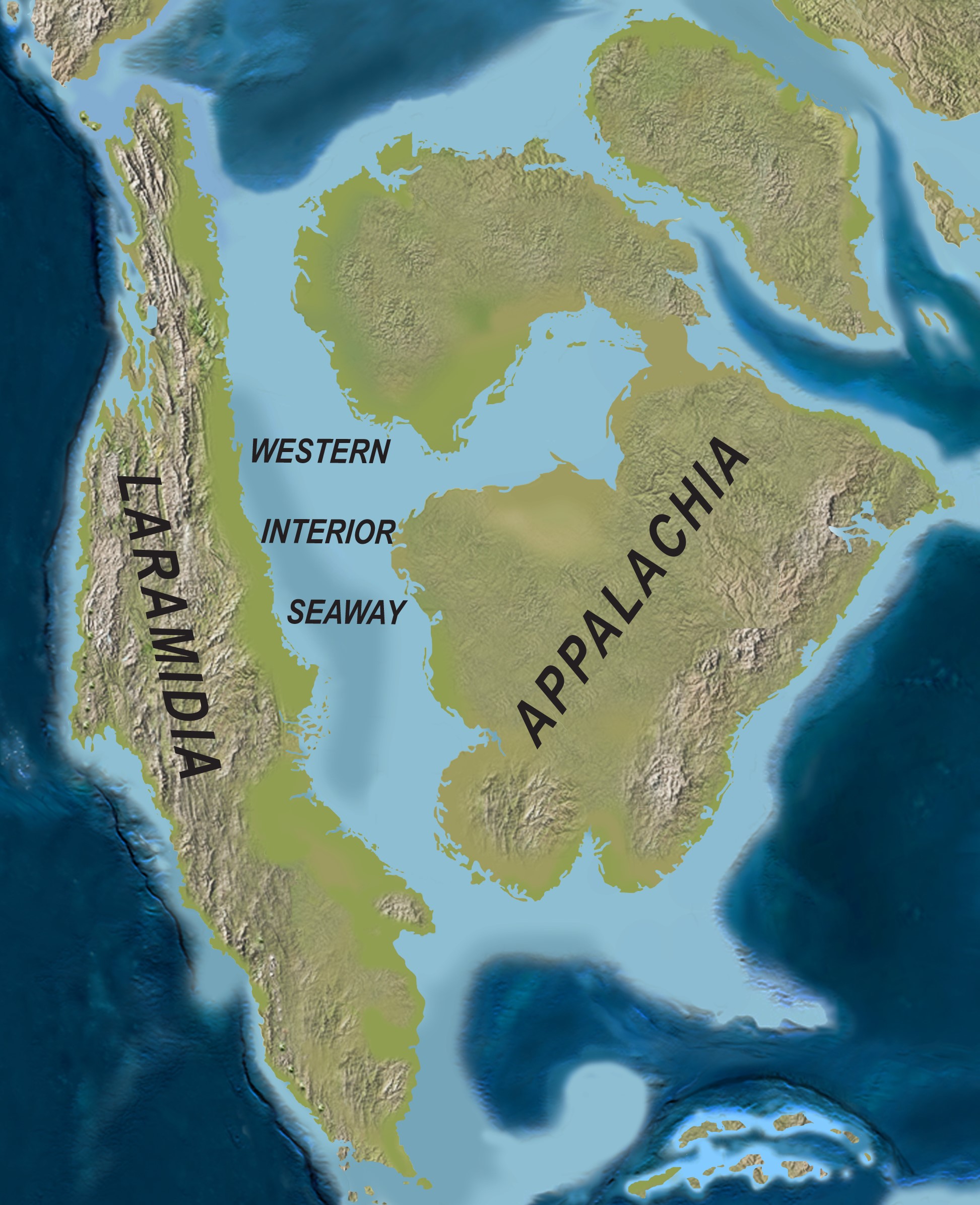
-
Article
Western Manitoba Centennial Auditorium
Western Manitoba Centennial Auditorium. Multi-purpose auditorium located next to the Queen Elizabeth II Music Building of Brandon University. The facility is operated by an incorporated board of governors appointed by the municipal and provincial governments.
"https://development.thecanadianencyclopedia.ca/images/tce_placeholder.jpg?v=e9dca980c9bdb3aa11e832e7ea94f5d9" // resources/views/front/categories/view.blade.php
https://development.thecanadianencyclopedia.ca/images/tce_placeholder.jpg?v=e9dca980c9bdb3aa11e832e7ea94f5d9
-
Article
Western Ontario Conservatory of Music
Western Ontario Conservatory of Music (WOCM). Teaching and examining body operated under the auspices of the University of Western Ontario 1934-97.
"https://development.thecanadianencyclopedia.ca/images/tce_placeholder.jpg?v=e9dca980c9bdb3aa11e832e7ea94f5d9" // resources/views/front/categories/view.blade.php
https://development.thecanadianencyclopedia.ca/images/tce_placeholder.jpg?v=e9dca980c9bdb3aa11e832e7ea94f5d9
-
Article
Westlock
Westlock, Alta, incorporated as a town in 1916, population 4823 (2011c), 5008 (2006c). The Town of Westlock is located 80 km northwest of Edmonton.
"https://development.thecanadianencyclopedia.ca/images/tce_placeholder.jpg?v=e9dca980c9bdb3aa11e832e7ea94f5d9" // resources/views/front/categories/view.blade.php
https://development.thecanadianencyclopedia.ca/images/tce_placeholder.jpg?v=e9dca980c9bdb3aa11e832e7ea94f5d9
-
Article
Westmount
Westmount's location on the slopes of Mont Royal attracted well-to-do residents, and it quickly became one of Canada's most fashionable communities. Long considered an English-speaking enclave in Montréal, it is now a bilingual community with a varied population.
"https://d2ttikhf7xbzbs.cloudfront.net/media/media/cf92a9ab-23d8-46fd-a222-55134cd53cb5.jpg" // resources/views/front/categories/view.blade.php
https://d2ttikhf7xbzbs.cloudfront.net/media/media/cf92a9ab-23d8-46fd-a222-55134cd53cb5.jpg
-
Article
Westport
Westport, NS, incorporated as a village in 1946, population 234 (2011c), 249 (2006c). The Village of Westport is located at the southern tip of Digby Neck, on the eastern side of Brier Island.
"https://development.thecanadianencyclopedia.ca/images/tce_placeholder.jpg?v=e9dca980c9bdb3aa11e832e7ea94f5d9" // resources/views/front/categories/view.blade.php
https://development.thecanadianencyclopedia.ca/images/tce_placeholder.jpg?v=e9dca980c9bdb3aa11e832e7ea94f5d9