Browse "Places"
-
Article
Foxe Basin
Foxe Basin is bordered on its eastern and northern sides by the coast of Baffin Island and in the west by the Melville Peninsula.
"https://development.thecanadianencyclopedia.ca/images/tce_placeholder.jpg?v=e9dca980c9bdb3aa11e832e7ea94f5d9" // resources/views/front/categories/view.blade.php
https://development.thecanadianencyclopedia.ca/images/tce_placeholder.jpg?v=e9dca980c9bdb3aa11e832e7ea94f5d9
-
Article
Francis Winspear Centre for Music
The tall, rectangular "performance chamber" is shaped in the traditional "shoebox" design found in some of the most renowned 19th-century European halls, such as the Tonhalle in Zurich, the Concertgebouw in Amsterdam and the Musikvereinsaal in Vienna.
"https://d2ttikhf7xbzbs.cloudfront.net/media/media/c5a96f65-d243-4149-8e5f-fe841e9d28ce.jpg" // resources/views/front/categories/view.blade.php
https://d2ttikhf7xbzbs.cloudfront.net/media/media/c5a96f65-d243-4149-8e5f-fe841e9d28ce.jpg
-
Article
Francis Winspear Centre for Music
Funding and DevelopmentIn 1983 a feasibility committee confirmed the need for a new concert hall for the Edmonton Symphony Orchestra, and the same year the Edmonton Concert Hall Foundation was formed under president David Norwood.
"https://d2ttikhf7xbzbs.cloudfront.net/media/media/c5a96f65-d243-4149-8e5f-fe841e9d28ce.jpg" // resources/views/front/categories/view.blade.php
https://d2ttikhf7xbzbs.cloudfront.net/media/media/c5a96f65-d243-4149-8e5f-fe841e9d28ce.jpg
-
Article
Francophones of Saskatchewan (Fransaskois)
The Fransaskois are francophones living in Saskatchewan. According to recent Canadian statistics, 1.5 per cent of the population (16,373 inhabitants) have French as their mother tongue and 1.3 per cent of the population (14,440 inhabitants) have French as their first official language (see French language in Canada).
"https://d2ttikhf7xbzbs.cloudfront.net/media/new_article_images/Fransaskois/Flag_Francophones_Saskatchewan_Fransaskois.png" // resources/views/front/categories/view.blade.php
https://d2ttikhf7xbzbs.cloudfront.net/media/new_article_images/Fransaskois/Flag_Francophones_Saskatchewan_Fransaskois.png
-
Article
Frank Slide Interpretive Centre
The Frank Slide Interpretive Centre is located on the site of the FRANK SLIDE, in the municipality of CROWSNEST PASS, Alta. On 29 April 1903 part of Turtle Mountain broke away and slid through part of the mining community of Frank. There is still considerable controversy over the cause of the slide.
"https://development.thecanadianencyclopedia.ca/images/tce_placeholder.jpg?v=e9dca980c9bdb3aa11e832e7ea94f5d9" // resources/views/front/categories/view.blade.php
https://development.thecanadianencyclopedia.ca/images/tce_placeholder.jpg?v=e9dca980c9bdb3aa11e832e7ea94f5d9
-
Article
Fraser River
The Fraser River is the longest river in British Columbia, stretching 1,375 km. It begins on the western side of the Rocky Mountains at Mount Robson Provincial Park, and ends in the Strait of Georgia at Vancouver. Named for explorer Simon Fraser, the river was a transportation route and source of food for the Indigenous people of the region long before Fraser travelled its waters. In 1858, gold was discovered on sandbars south of Yale, setting off the Fraser River Gold rush.
"https://d2ttikhf7xbzbs.cloudfront.net/media/media/3a0bfcc6-c4db-40cb-9d96-e5db248cc7e2.jpg" // resources/views/front/categories/view.blade.php
https://d2ttikhf7xbzbs.cloudfront.net/media/media/3a0bfcc6-c4db-40cb-9d96-e5db248cc7e2.jpg
-
Article
Fraser River Canyon
The Fraser River Canyon was formed during the Miocene period (22.9-5.33 million years ago) when the river cut down into the uplifting southern part of the Interior Plateau of British Columbia. The canyon characteristics of this
"https://d2ttikhf7xbzbs.cloudfront.net/media/media/49e5b82d-d0a2-4ca6-aa37-99ecf1243a3d.jpg" // resources/views/front/categories/view.blade.php
https://d2ttikhf7xbzbs.cloudfront.net/media/media/49e5b82d-d0a2-4ca6-aa37-99ecf1243a3d.jpg
-
Article
Fraser River Gold Rush
In 1858, around 30,000 gold seekers flooded the banks of the Fraser River from Hope to just north of Lillooet in British Columbia’s first significant gold rush. Although it dissipated by the mid-1860s, the Fraser River Gold Rush had a significant impact on the area’s Indigenous peoples and resulted in the Fraser Canyon War. Fears that the massive influx of American miners would lead the United States to annex the non-sovereign British territory known as New Caledonia also resulted in the founding of British Columbia as a colony on 2 August 1858 (see The Fraser River Gold Rush and the Founding of British Columbia). By the mid-1860s, the Fraser Rush collapsed, and British Columbia sank into a recession.
"https://d2ttikhf7xbzbs.cloudfront.net/media/new_article_images/FraserCanyonWar/Fraser Canyon near Chapmans Bar, Daniel Marshall(1).jpg" // resources/views/front/categories/view.blade.php
https://d2ttikhf7xbzbs.cloudfront.net/media/new_article_images/FraserCanyonWar/Fraser Canyon near Chapmans Bar, Daniel Marshall(1).jpg.jpg)
-
Article
Fraser River Lowland
The Fraser River Lowland is a triangular area in southwestern British Columbia. The eastern apex of the triangle is at Hope, about 160 km inland from the Strait of Georgia. From here, the lowland broadens to the west to a width of about 50 km. The international boundary between British Columbia and Washington State crosses the southwestern part of the lowland. The Coast Mountains form the northern boundary of the delta-lowland. The Fraser River Lowland is the largest area of level land with suitable agricultural soils in coastal British Columbia.
"https://d2ttikhf7xbzbs.cloudfront.net/media/new_article_images/FraserRiverLowland/FraserRiverLowlandMap.png" // resources/views/front/categories/view.blade.php
https://d2ttikhf7xbzbs.cloudfront.net/media/new_article_images/FraserRiverLowland/FraserRiverLowlandMap.png
-
Article
Fredericton
Fredericton, NB, incorporated as a city in 1848, population 58,220 (2016 c), 56,224 (2011 c). The city of Fredericton is the provincial capital and is located in central New Brunswick, just below the head of tide on the Saint John River, 135 km inland from the Bay of Fundy.
"https://d2ttikhf7xbzbs.cloudfront.net/media/media/61e2af78-c031-49ab-b8d2-9e86e8377475.jpg" // resources/views/front/categories/view.blade.php
https://d2ttikhf7xbzbs.cloudfront.net/media/media/61e2af78-c031-49ab-b8d2-9e86e8377475.jpg
-
Article
Music in Fredericton
Fredericton, NB. New Brunswick's capital city, located on the Saint John River on the site of a 1732 Acadian, and later Loyalist English, settlement at St Anne's Point. The name Fredericton was adopted in 1785. Incorporation as a city was accomplished in 1848.
"https://development.thecanadianencyclopedia.ca/images/tce_placeholder.jpg?v=e9dca980c9bdb3aa11e832e7ea94f5d9" // resources/views/front/categories/view.blade.php
https://development.thecanadianencyclopedia.ca/images/tce_placeholder.jpg?v=e9dca980c9bdb3aa11e832e7ea94f5d9
-
Article
French River
The French River, 290 km long (to head of Sturgeon River), rises from Lake Nipissing in northeastern Ontario and flows 110 km west towards Georgian Bay.
"https://development.thecanadianencyclopedia.ca/images/tce_placeholder.jpg?v=e9dca980c9bdb3aa11e832e7ea94f5d9" // resources/views/front/categories/view.blade.php
https://development.thecanadianencyclopedia.ca/images/tce_placeholder.jpg?v=e9dca980c9bdb3aa11e832e7ea94f5d9
-
Article
French Shore
The French Shore was an area of coastal Newfoundland where French fishermen enjoyed treaty rights granted by the British from 1713 to 1904.
"https://development.thecanadianencyclopedia.ca/images/tce_placeholder.jpg?v=e9dca980c9bdb3aa11e832e7ea94f5d9" // resources/views/front/categories/view.blade.php
https://development.thecanadianencyclopedia.ca/images/tce_placeholder.jpg?v=e9dca980c9bdb3aa11e832e7ea94f5d9
-
Article
Frobisher Bay
Iqaluit is near a traditional South Baffin Inuit fishing camp, where a summer camp was established each year to fish (photo by Barbara Brundege and Eugene Fisher).\r\n Frobisher Bay is a deep indentation in the extreme southeast coastline of BAFFIN ISLAND, over 230 km long and 40 km wide at the mouth, narrowing to 20 km towards its head. The configuration of the bay has a funnelling effect, so that the harbour of the city...
"https://d2ttikhf7xbzbs.cloudfront.net/media/media/66fc9616-fe99-4ef4-a49a-d7528ad2566e.jpg" // resources/views/front/categories/view.blade.php
https://d2ttikhf7xbzbs.cloudfront.net/media/media/66fc9616-fe99-4ef4-a49a-d7528ad2566e.jpg
-
Article
Fruitvale
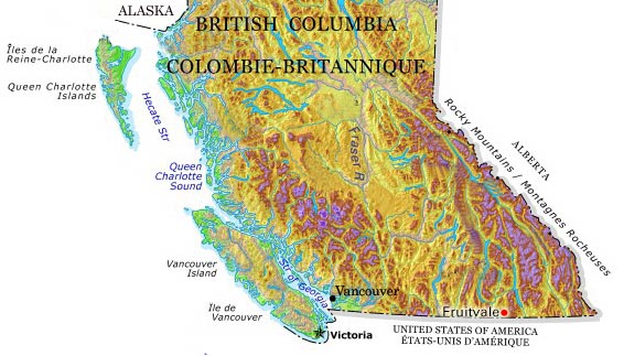
Fruitvale, BC, incorporated as a village in 1952, population 2016 (2011c), 1952 (2006c). The Village of Fruitvale is located in the southern interior of BC close to the US border, 11 km east of TRAIL, 645 km east of Vancouver.
"https://d2ttikhf7xbzbs.cloudfront.net/media/media/0f6874e9-2706-4ff6-a872-f66d45e622f8.jpg" // resources/views/front/categories/view.blade.php
https://d2ttikhf7xbzbs.cloudfront.net/media/media/0f6874e9-2706-4ff6-a872-f66d45e622f8.jpg
