Browse "Places"
-
Article
Lumsden
Lumsden, Sask, incorporated as a town in 1905, population 1631 (2011c), 1523 (2006c). The Town of Lumsden is located 26 km northeast of REGINA, nestled in the rolling terrain of the QU'APPELLE RIVER valley. The first settlers arrived in 1881 and named their community Happy Hollow.
"https://development.thecanadianencyclopedia.ca/images/tce_placeholder.jpg?v=e9dca980c9bdb3aa11e832e7ea94f5d9" // resources/views/front/categories/view.blade.php
https://development.thecanadianencyclopedia.ca/images/tce_placeholder.jpg?v=e9dca980c9bdb3aa11e832e7ea94f5d9
-
Article
Lunenburg
Lunenburg, Nova Scotia, incorporated as a town in 1888, population 2,405 (2021 census), 2,262 (2016 census). The town of Lunenburg, the seat of Lunenburg County, is located on Lunenburg Bay, 90 km southwest of Halifax.
"https://d2ttikhf7xbzbs.cloudfront.net/media/media/814a3eda-73fc-4887-bc3d-07de96548d81.jpg" // resources/views/front/categories/view.blade.php
https://d2ttikhf7xbzbs.cloudfront.net/media/media/814a3eda-73fc-4887-bc3d-07de96548d81.jpg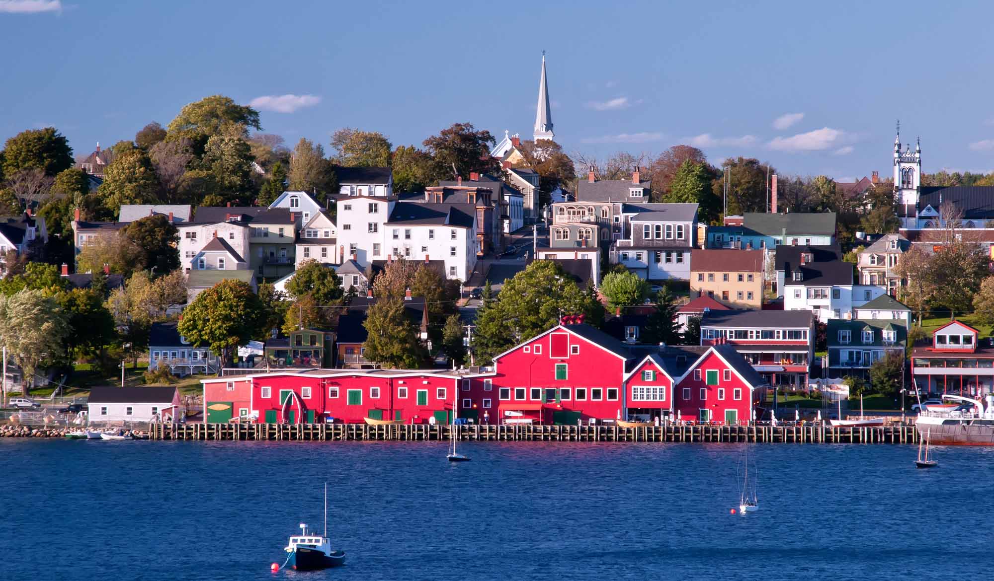
-
Article
Music in Lunenburg
Seaport community founded in 1753 on the south shore of Nova Scotia by German, Swiss, Huguenot, and British settlers at a site known previously as Malagash. In 1986 its population was 2972.
"https://development.thecanadianencyclopedia.ca/images/tce_placeholder.jpg?v=e9dca980c9bdb3aa11e832e7ea94f5d9" // resources/views/front/categories/view.blade.php
https://development.thecanadianencyclopedia.ca/images/tce_placeholder.jpg?v=e9dca980c9bdb3aa11e832e7ea94f5d9
-
Article
Lynn Lake
Lynn Lake, Manitoba, incorporated as a town in 1997, population 482 (2011c), 714 (2006c). The Town of Lynn Lake is a community located 1066 km by road northwest of Winnipeg on the Canadian SHIELD.
"https://development.thecanadianencyclopedia.ca/images/tce_placeholder.jpg?v=e9dca980c9bdb3aa11e832e7ea94f5d9" // resources/views/front/categories/view.blade.php
https://development.thecanadianencyclopedia.ca/images/tce_placeholder.jpg?v=e9dca980c9bdb3aa11e832e7ea94f5d9
-
Article
Lytton
Lytton, British Columbia, incorporated as a village in 1945, population 249 (2016 census), 228 (2011 census). The village of Lytton is located on the Trans-Canada Highway, 260 km northeast of Vancouver, at the junction of the Thompson and Fraser rivers. This is one of the driest and warmest spots in Canada.
"https://d2ttikhf7xbzbs.cloudfront.net/media/media/597fe6e1-a416-4a06-8227-f84345c5562b.jpg" // resources/views/front/categories/view.blade.php
https://d2ttikhf7xbzbs.cloudfront.net/media/media/597fe6e1-a416-4a06-8227-f84345c5562b.jpg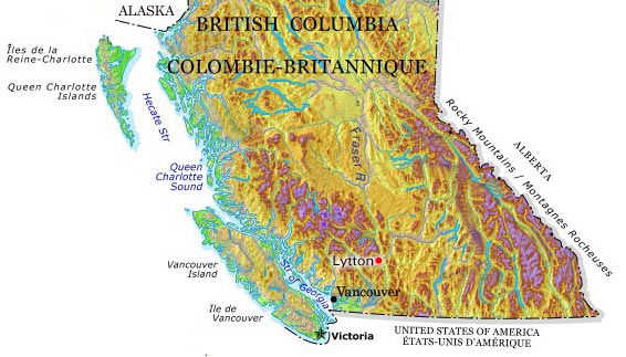
-
Article
MacDonald Farm Historic Site
This provincial farm is a HISTORIC SITE located in the MIRAMICHI region of New Brunswick near Bartibog. The farm was founded by Alexander MacDonald, a Scot who had come to North America as a soldier during the AMERICAN REVOLUTION.
"https://development.thecanadianencyclopedia.ca/images/tce_placeholder.jpg?v=e9dca980c9bdb3aa11e832e7ea94f5d9" // resources/views/front/categories/view.blade.php
https://development.thecanadianencyclopedia.ca/images/tce_placeholder.jpg?v=e9dca980c9bdb3aa11e832e7ea94f5d9
-
Article
Mackenzie
Mackenzie, BC, incorporated as a district municipality in 1966, population 3507 (2011c), 4539 (2006c). The District of Mackenzie is situated in northern British Columbia near the south end of Williston Lake in the Rocky Mountain Trench.
"https://development.thecanadianencyclopedia.ca/images/tce_placeholder.jpg?v=e9dca980c9bdb3aa11e832e7ea94f5d9" // resources/views/front/categories/view.blade.php
https://development.thecanadianencyclopedia.ca/images/tce_placeholder.jpg?v=e9dca980c9bdb3aa11e832e7ea94f5d9
-
Article
Mackenzie-Grease Trail
The Mackenzie-Grease Trail represents the final 350 km link which Alexander Mackenzie followed in the first recorded crossing of continental North America in 1793.
"https://development.thecanadianencyclopedia.ca/images/tce_placeholder.jpg?v=e9dca980c9bdb3aa11e832e7ea94f5d9" // resources/views/front/categories/view.blade.php
https://development.thecanadianencyclopedia.ca/images/tce_placeholder.jpg?v=e9dca980c9bdb3aa11e832e7ea94f5d9
-
Article
Mackenzie Highway
Eighty km northwest of Enterprise, a ferry connects with the highway to Yellowknife, and connecting roads to the east serve Fort Resolution and Fort Smith. The section from Enterprise to Hay River is now a separate highway. First built as an all-weather road, some of its length has been paved.
"https://d2ttikhf7xbzbs.cloudfront.net/media/media/2862aeaf-cace-4b85-aac6-6d4f4ad9c96e.jpg" // resources/views/front/categories/view.blade.php
https://d2ttikhf7xbzbs.cloudfront.net/media/media/2862aeaf-cace-4b85-aac6-6d4f4ad9c96e.jpg
-
Article
Mackenzie King Island
Mackenzie King Island, 5048 km2, is one of the central islands in the Queen Elizabeth Islands of the Arctic Archipelago.
"https://development.thecanadianencyclopedia.ca/images/tce_placeholder.jpg?v=e9dca980c9bdb3aa11e832e7ea94f5d9" // resources/views/front/categories/view.blade.php
https://development.thecanadianencyclopedia.ca/images/tce_placeholder.jpg?v=e9dca980c9bdb3aa11e832e7ea94f5d9
-
Article
Mackenzie Mountains
Named after Prime Minister Alexander Mackenzie, they are a northern continuation, 800 km long, of the eastern system of the Rocky Mountains, composed almost entirely of folded sedimentary strata.
"https://d2ttikhf7xbzbs.cloudfront.net/TCEImages/ffb07091-94d9-4b4d-bca4-707831bf46a6.jpg" // resources/views/front/categories/view.blade.php
https://d2ttikhf7xbzbs.cloudfront.net/TCEImages/ffb07091-94d9-4b4d-bca4-707831bf46a6.jpg
-
Article
Mackenzie River
The Mackenzie River’s main stem is 1,738 km long, making it one of the longest rivers in Canada. The Mackenzie River system, which includes tributaries such as the Liard River, is 4,241 km. The Mackenzie River runs northwest through the Northwest Territories, from Great Slave Lake to the Beaufort Sea. Its total drainage basin — 1.8 million km2 — is the largest of any river in Canada and its mean discharge of 9,700 m3/s is second only to that of the St. Lawrence. The river's peak discharge occurs in June, but its flow is generally uniform because of the flat topography east of the river and the many large lakes in the system. The break-up of ice begins at the Liard River in late April, early May. The river is free of ice by early June and stays open until November.
"https://d2ttikhf7xbzbs.cloudfront.net/media/media/b24a9945-1be2-4260-8b49-797cdcb3558e.jpg" // resources/views/front/categories/view.blade.php
https://d2ttikhf7xbzbs.cloudfront.net/media/media/b24a9945-1be2-4260-8b49-797cdcb3558e.jpg
-
Article
Mackinaw Boat
Mackinaw Boat, a strong flat-bottomed boat, pointed at each end and with a hold in the middle, was used by fur traders during the French regime for running downstream. It was later adapted for open water by the addition of 2 sails and a steering oar. By the 1870s a distinctive type, 6.7 m to 8.
"https://development.thecanadianencyclopedia.ca/images/tce_placeholder.jpg?v=e9dca980c9bdb3aa11e832e7ea94f5d9" // resources/views/front/categories/view.blade.php
https://development.thecanadianencyclopedia.ca/images/tce_placeholder.jpg?v=e9dca980c9bdb3aa11e832e7ea94f5d9
-
Article
Madawaska: A Canadian-American Borderland, from Colonization to Division
Madawaska was a borderland that comprised parts of New Brunswick, Lower Canada, and the state of Maine, concentrated along the upper Saint John River valley.
"https://d2ttikhf7xbzbs.cloudfront.net/media/media/0052e055-bf0b-4980-8f10-08f926f15b9b.jpg" // resources/views/front/categories/view.blade.php
https://d2ttikhf7xbzbs.cloudfront.net/media/media/0052e055-bf0b-4980-8f10-08f926f15b9b.jpg
-
Article
Magog
In 1888 the village of Magog separated from the municipality of Magog Township (established 1855) and soon incorporated as a town.
"https://development.thecanadianencyclopedia.ca/images/tce_placeholder.jpg?v=e9dca980c9bdb3aa11e832e7ea94f5d9" // resources/views/front/categories/view.blade.php
https://development.thecanadianencyclopedia.ca/images/tce_placeholder.jpg?v=e9dca980c9bdb3aa11e832e7ea94f5d9