Browse "Places"
-
Article
Mississaugas of the Credit First Nation
The Mississaugas of the Credit are a First Nation based in southwestern Ontario. Their reserve, known as New Credit, occupies just under 6,000 acres (about 24 km2). It straddles Brant and Haldimand Counties and is adjacent to the Six Nations of the Grand River reserve. As of 2022, 957 of the First Nation’s 2,731 members live on reserve (see also Reserves in Ontario).
"https://d2ttikhf7xbzbs.cloudfront.net/MississaugasOfTheCreditFN/ThreeFires31.JPG" // resources/views/front/categories/view.blade.php
https://d2ttikhf7xbzbs.cloudfront.net/MississaugasOfTheCreditFN/ThreeFires31.JPG
-
Article
Mistaken Point
Mistaken Point was designated as Canada’s 18th World Heritage Site by the United Nations Educational, Scientific and Cultural Organization (UNESCO) in 2016. It is located in southeastern Newfoundland. Mistaken Point is the oldest grouping of large, biologically complex fossilized creatures found anywhere in the world. The fossils date from 580 to 560 million years ago, when large, multicellular organisms began to appear. Mistaken Point was the fifth Canadian fossil site to be recognized by UNESCO, following Dinosaur Provincial Park (1979), Canadian Rocky Mountain Parks (1984), Miguasha National Park (1999) and Joggins Fossil Cliffs (2008).
"https://d2ttikhf7xbzbs.cloudfront.net/media/new_article_images/MistakenPoint/7230862706_8985c1c244_o.jpg" // resources/views/front/categories/view.blade.php
https://d2ttikhf7xbzbs.cloudfront.net/media/new_article_images/MistakenPoint/7230862706_8985c1c244_o.jpg
-
Article
Mistassini
Mistassini, Qué, was a separate municipality (inc 1976) until it merged with Dolbeau to form the city of Dolbeau-Mistassini.
"https://development.thecanadianencyclopedia.ca/images/tce_placeholder.jpg?v=e9dca980c9bdb3aa11e832e7ea94f5d9" // resources/views/front/categories/view.blade.php
https://development.thecanadianencyclopedia.ca/images/tce_placeholder.jpg?v=e9dca980c9bdb3aa11e832e7ea94f5d9
-
Article
Monashee Mountains
Monashee Mountains are a 400-km-long range of varied origin in southern BC. To the W they merge with the Okanagan and Shuswap highlands; their eastern boundary is the S-flowing COLUMBIA RIVER. The highest point in the range is 3375 m.
"https://development.thecanadianencyclopedia.ca/images/tce_placeholder.jpg?v=e9dca980c9bdb3aa11e832e7ea94f5d9" // resources/views/front/categories/view.blade.php
https://development.thecanadianencyclopedia.ca/images/tce_placeholder.jpg?v=e9dca980c9bdb3aa11e832e7ea94f5d9
-
Article
Moncton
Moncton, NB, incorporated as a city in 1890, population 71,889 (2016 census),69,074 (2011 census), is the largest city in New Brunswick. The City of Moncton is located in eastern New Brunswick on a bend of the Petitcodiac River. With a population of 144,810 (2016) the Greater Moncton region includes the steadily growing city of Dieppe and the town of Riverview.
"https://development.thecanadianencyclopedia.ca/images/tce_placeholder.jpg?v=e9dca980c9bdb3aa11e832e7ea94f5d9" // resources/views/front/categories/view.blade.php
https://development.thecanadianencyclopedia.ca/images/tce_placeholder.jpg?v=e9dca980c9bdb3aa11e832e7ea94f5d9
-
Article
Music in Moncton
New Brunswick city originally known as LeCoude and first settled in 1750 by Acadians. The Acadians were dispersed in 1758 but returned in sufficient numbers to constitute a fundamental segment of the Moncton community.
"https://development.thecanadianencyclopedia.ca/images/tce_placeholder.jpg?v=e9dca980c9bdb3aa11e832e7ea94f5d9" // resources/views/front/categories/view.blade.php
https://development.thecanadianencyclopedia.ca/images/tce_placeholder.jpg?v=e9dca980c9bdb3aa11e832e7ea94f5d9
-
Article
Mont-Joli
Further growth resulted from the establishment of train repair yards. The headquarters of the Canada and Gulf Terminal Ry (linking Mont-Joli and Matane) located in the village in 1910. These developments led to the opening of a foundry that produced railway equipment.
"https://development.thecanadianencyclopedia.ca/images/tce_placeholder.jpg?v=e9dca980c9bdb3aa11e832e7ea94f5d9" // resources/views/front/categories/view.blade.php
https://development.thecanadianencyclopedia.ca/images/tce_placeholder.jpg?v=e9dca980c9bdb3aa11e832e7ea94f5d9
-
Article
Mont-Saint-Hilaire
This area, part of the seigneury granted to Jean-Baptiste Hertel de Rouville in 1694, was sufficiently settled at the end of the 18th century to warrant the creation of a mission church, Saint-Hilaire.
"https://development.thecanadianencyclopedia.ca/images/tce_placeholder.jpg?v=e9dca980c9bdb3aa11e832e7ea94f5d9" // resources/views/front/categories/view.blade.php
https://development.thecanadianencyclopedia.ca/images/tce_placeholder.jpg?v=e9dca980c9bdb3aa11e832e7ea94f5d9
-
Article
Mont Sainte-Anne
Internationally known for its SKIING facilities, 7 World Cup races have been held there since 1969. The area is superbly equipped; downhill skiers and snowboarders enjoy 51 runs totalling 60 km (15 km are illuminated for night skiing).
"https://d2ttikhf7xbzbs.cloudfront.net/media/media/d7932e1a-76b9-4c9e-bbb5-1ffc418839f7.jpg" // resources/views/front/categories/view.blade.php
https://d2ttikhf7xbzbs.cloudfront.net/media/media/d7932e1a-76b9-4c9e-bbb5-1ffc418839f7.jpg
-
"https://d2ttikhf7xbzbs.cloudfront.net/media/media/081947b9-bef7-47f0-b7c2-f8dbb47f7f9a.jpg" // resources/views/front/categories/view.blade.php
https://d2ttikhf7xbzbs.cloudfront.net/media/media/081947b9-bef7-47f0-b7c2-f8dbb47f7f9a.jpg
-
Article
Montague
While it still lacks an industrial base, the town has experienced renewed prosperity with the agricultural revitalization that began in the 1960s. Out-of-province investment established tobacco farms and rejuvenated the mixed- and dairy-farming industries.
"https://development.thecanadianencyclopedia.ca/images/tce_placeholder.jpg?v=e9dca980c9bdb3aa11e832e7ea94f5d9" // resources/views/front/categories/view.blade.php
https://development.thecanadianencyclopedia.ca/images/tce_placeholder.jpg?v=e9dca980c9bdb3aa11e832e7ea94f5d9
-
Article
Montgomery's Tavern
Montgomery’s Tavern was a focal point in the Rebellion of Upper Canada in 1837. Owner John Montgomery sympathized with the Reform movement but not the actual rebellion. His tavern served as the headquarters for William Lyon Mackenzie — culminating in a skirmish there between local rebels and government militia. The location in Toronto today, at Yonge Street and Montgomery Avenue, is a national historic site.
"https://d2ttikhf7xbzbs.cloudfront.net/media/media/ab6ffbc8-72e2-4fc1-9007-43a1b2c8948d.jpg" // resources/views/front/categories/view.blade.php
https://d2ttikhf7xbzbs.cloudfront.net/media/media/ab6ffbc8-72e2-4fc1-9007-43a1b2c8948d.jpg
-
Article
Montmagny
Jacques CARTIER passed Montmagny and its many offshore islands in 1535 and noted its beautiful surroundings. In 1646 a seigneury containing the area was granted to Huault, although permanent European habitation did not begin until the 1670s.
"https://d2ttikhf7xbzbs.cloudfront.net/media/media/6611985e-9eb7-4000-aa69-69a6aff45685.jpg" // resources/views/front/categories/view.blade.php
https://d2ttikhf7xbzbs.cloudfront.net/media/media/6611985e-9eb7-4000-aa69-69a6aff45685.jpg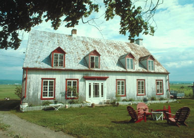
-
Article
Montmorency
The Montmorency Manoir, built in 1781 by Frederick HALDIMAND, governor general in chief of Canada, was inhabited 1791-94 by the duke of Kent, father of Queen Victoria. First known as the "Kent House," it suffered a devastating fire in 1993 but was rebuilt by the following year.
"https://development.thecanadianencyclopedia.ca/images/tce_placeholder.jpg?v=e9dca980c9bdb3aa11e832e7ea94f5d9" // resources/views/front/categories/view.blade.php
https://development.thecanadianencyclopedia.ca/images/tce_placeholder.jpg?v=e9dca980c9bdb3aa11e832e7ea94f5d9
-
Article
Montreal
Montreal, Quebec, incorporated as a city in 1832, population 1,762,949 (2021 census), 1,704,694 (2016 census). Montreal is Canada’s second largest city and is home to nearly a quarter of the province of Quebec’s population. It is the metropolis of the province and was the most populous city in Canada for a century and a half. It is located in southwestern Quebec on Île de Montreal at the confluence of the St. Lawrence and Ottawa rivers. Montreal is a major industrial centre, commercial and financial metropolis, railway and maritime bridgehead, and one of the centres of francophone culture in North America. It is one of the world's great cities and enjoys international acclaim.
"https://d2ttikhf7xbzbs.cloudfront.net/media/media/Downtown_MTL.jpg" // resources/views/front/categories/view.blade.php
https://d2ttikhf7xbzbs.cloudfront.net/media/media/Downtown_MTL.jpg