Browse "Places"
-
Article
Nahanni National Park Reserve
Nahanni National Park Reserve (est 1976, 4765.2 km2) is a wilderness of rugged mountains, wild rivers and luxurious hot springs stretched along the South Nahanni River in the southwest corner of the Northwest Territories. The park was recognized as a United Nations World Heritage Site in 1978.
"https://d2ttikhf7xbzbs.cloudfront.net/media/media/f03ee7f1-6a31-4148-8ca4-a42264dd3a8e.jpg" // resources/views/front/categories/view.blade.php
https://d2ttikhf7xbzbs.cloudfront.net/media/media/f03ee7f1-6a31-4148-8ca4-a42264dd3a8e.jpg
-
Article
Nain
Nain, NL, incorporated as a town in 1970, population 1188 (2011c), 1034 (2006c). The Town of Nain is the most northerly community on the Labrador coast.
"https://development.thecanadianencyclopedia.ca/images/tce_placeholder.jpg?v=e9dca980c9bdb3aa11e832e7ea94f5d9" // resources/views/front/categories/view.blade.php
https://development.thecanadianencyclopedia.ca/images/tce_placeholder.jpg?v=e9dca980c9bdb3aa11e832e7ea94f5d9
-
Article
Nakusp
Nakusp, British Columbia, incorporated as a village in 1964, population 1,605 (2016 census), 1,569 (2011 census). The village of Nakusp is located on the east shore of Upper Arrow Lake at the foot of the Selkirk Mountains. It is in the West Kootenay district of south-eastern British Columbia. Nakusp is located on the traditional territory of the Sinixt, Ktunaxa, Secwepemc and Okanagan peoples. (See also Interior Salish.) The name is derived from a Sinixt word, though its meaning is debated. One interpretation is that the name Nakusp comes from a word meaning “the bay behind the long point,” another is that it means, “closed-in” or “safe.”
"https://development.thecanadianencyclopedia.ca/images/tce_placeholder.jpg?v=e9dca980c9bdb3aa11e832e7ea94f5d9" // resources/views/front/categories/view.blade.php
https://development.thecanadianencyclopedia.ca/images/tce_placeholder.jpg?v=e9dca980c9bdb3aa11e832e7ea94f5d9
-
Article
Nanaimo
Nanaimo, BC, incorporated as a city in 1874, population 83 810 (2011c), 78 692 (2006c).
"https://d2ttikhf7xbzbs.cloudfront.net/media/media/cabaef9d-ff42-41e5-bfd9-1ef1705f926c.jpg" // resources/views/front/categories/view.blade.php
https://d2ttikhf7xbzbs.cloudfront.net/media/media/cabaef9d-ff42-41e5-bfd9-1ef1705f926c.jpg
-
Article
Nancy Island Historic Site
Nancy Island Historic Site is situated about 2 km from the mouth of where the Nottawasaga River flows into southern GEORGIAN BAY, Ont.
"https://development.thecanadianencyclopedia.ca/images/tce_placeholder.jpg?v=e9dca980c9bdb3aa11e832e7ea94f5d9" // resources/views/front/categories/view.blade.php
https://development.thecanadianencyclopedia.ca/images/tce_placeholder.jpg?v=e9dca980c9bdb3aa11e832e7ea94f5d9
-
Article
Nanisivik
Nanisivik, Nunavut, is a settlement located on the south shore of Strathcona Sound on the Borden Peninsula of Baffin Island, 280 km northwest of Iqaluit.
"https://development.thecanadianencyclopedia.ca/images/tce_placeholder.jpg?v=e9dca980c9bdb3aa11e832e7ea94f5d9" // resources/views/front/categories/view.blade.php
https://development.thecanadianencyclopedia.ca/images/tce_placeholder.jpg?v=e9dca980c9bdb3aa11e832e7ea94f5d9
-
Article
Napaktulik Lake
Napaktulik Lake, 1080 km2, elevation 381 m, maximum length 60 km, is located in Nunavut almost on the Arctic Circle, 173 km south of Kugluktuk, NWT. The lake is fed by a tributary of the COPPERMINE RIVER and drains northeast to BATHURST INLET via the Hood River.
"https://development.thecanadianencyclopedia.ca/images/tce_placeholder.jpg?v=e9dca980c9bdb3aa11e832e7ea94f5d9" // resources/views/front/categories/view.blade.php
https://development.thecanadianencyclopedia.ca/images/tce_placeholder.jpg?v=e9dca980c9bdb3aa11e832e7ea94f5d9
-
Article
Nass River
Nass River is 380 km long, rises in the northern interior of BC and flows generally southwest, draining approximately 20 700 km2, to reach the Pacific at Portland Inlet. Its major tributaries are the Bell-Irving, Meziadin and Cranberry rivers.
"https://d2ttikhf7xbzbs.cloudfront.net/media/media/98c7f804-42d2-47dd-a13b-335cd43c959f.jpg" // resources/views/front/categories/view.blade.php
https://d2ttikhf7xbzbs.cloudfront.net/media/media/98c7f804-42d2-47dd-a13b-335cd43c959f.jpg
-
Article
National Assembly
The National Assembly (Assemblée Nationale) is the unicameral provincial legislature of Québec.
"https://d2ttikhf7xbzbs.cloudfront.net/media/media/f2856716-0ae7-436d-8286-d8fc3df5b4ca.jpg" // resources/views/front/categories/view.blade.php
https://d2ttikhf7xbzbs.cloudfront.net/media/media/f2856716-0ae7-436d-8286-d8fc3df5b4ca.jpg
-
Article
National Capital Region
The National Capital Region contains the cities of Ottawa, Ontario, and Gatineau, Quebec, as well as parts of their surrounding municipalities. In total, the region covers approximately 4,715 km2. While Ottawa is the capital of Canada by law, the National Capital Region is recognized as the seat of the federal government. A federal agency called the National Capital Commission represents the government for most planning matters in the region, in cooperation with provincial and municipal governments. The entire region is located within the traditional and unceded territory of the Algonquin people.
"https://d2ttikhf7xbzbs.cloudfront.net/media/new_article_images/NationalCapitalRegion/NCR_smallScale_topo_EN.jpg" // resources/views/front/categories/view.blade.php
https://d2ttikhf7xbzbs.cloudfront.net/media/new_article_images/NationalCapitalRegion/NCR_smallScale_topo_EN.jpg
-
Timelines
National Parks
Canada's national parks are protected areas established under federal legislation to preserve Canada's natural heritage.
"https://d2ttikhf7xbzbs.cloudfront.net/media/media/be7a97e5-19d2-4df5-b348-a549dd5b3fe7.jpg" // resources/views/front/categories/view.blade.php
https://d2ttikhf7xbzbs.cloudfront.net/media/media/be7a97e5-19d2-4df5-b348-a549dd5b3fe7.jpg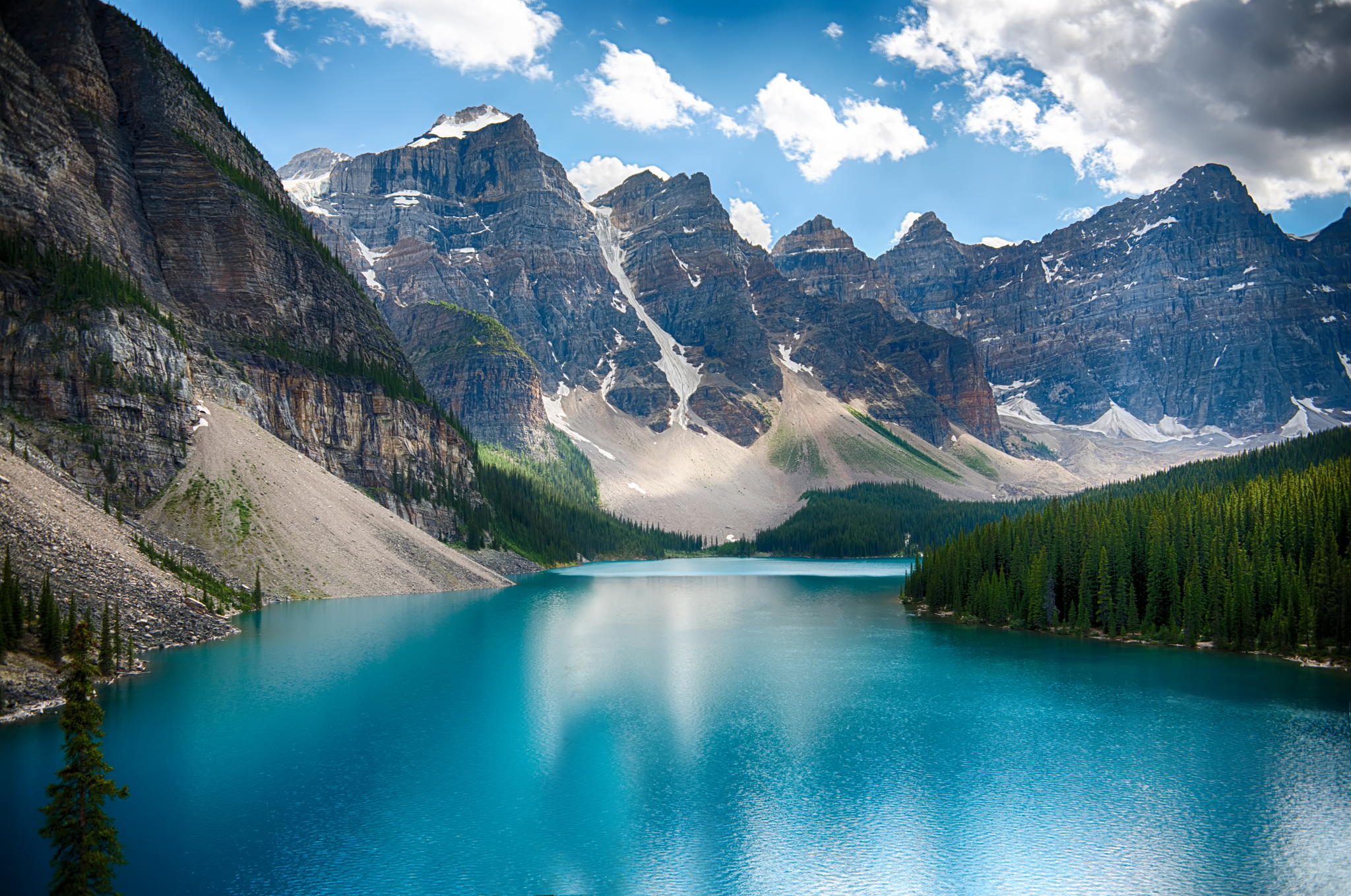
-
Article
National Parks of Canada
Canada’s national parks are protected areas established under federal legislation to preserve Canada’s natural heritage. They are administered by Parks Canada, a government agency that evolved from the world’s first national parks service, the Dominion Parks Branch, established in 1911. The National Parks System Plan, developed in 1970, divided Canada into 39 natural regions and set the goal of representing each region with at least one national park. Canada now has 48 national parks and national park reserves, and one national urban park, in 30 of these regions. In total, the parks cover more than 340,000 km2, which is over 3 per cent of Canada’s landmass. They protect important land and marine habitats, geographical features and sites of cultural significance. National parks also benefit local economies and the tourism industry in Canada. (This is the full-length entry about National Parks of Canada. For a plain-language summary, please see National Parks of Canada (Plain-Language Summary).)
"https://d2ttikhf7xbzbs.cloudfront.net/media/media/27f9bb3e-3454-4b12-9aca-ded0299bfe8c.jpg" // resources/views/front/categories/view.blade.php
https://d2ttikhf7xbzbs.cloudfront.net/media/media/27f9bb3e-3454-4b12-9aca-ded0299bfe8c.jpg
-
search.types.interactivemap
National Parks of Canada Interactive Map
The map below indicates the location of national parks and national park reserves in Canada. Click on individual points to learn a park’s name and the year it was established. Canada’s national parks and national park reserves are protected areas established under federal legislation. They aim to preserve Canada’s natural heritage. There are 48 national parks and national park reserves in Canada, and one national urban park. (See also National Parks of Canada)
"https://d2ttikhf7xbzbs.cloudfront.net/media/new_article_images/NationalParksInteractiveMap/NationalParksofCanadaScreenShot.png" // resources/views/front/categories/view.blade.php
https://d2ttikhf7xbzbs.cloudfront.net/media/new_article_images/NationalParksInteractiveMap/NationalParksofCanadaScreenShot.png
-
Article
National Parks of Canada (Plain-Language Summary)
Canada has 48 national parks and one national urban park. They were created and are run by the federal government. The national parks cover a vast amount of land — about 340,000 km2. This is about 3 per cent of Canada’s landmass. National parks serve two purposes. The first purpose is to preserve and protect nature. The second purpose is to give Canadians the chance to enjoy some of the country’s most beautiful and important natural settings. Millions of Canadians visit national parks every year. (This article is a plain-language summary of National Parks. If you are interested in reading about this topic in more depth, please see our full-length entry, National Parks of Canada.)
"https://d2ttikhf7xbzbs.cloudfront.net/media/media/27f9bb3e-3454-4b12-9aca-ded0299bfe8c.jpg" // resources/views/front/categories/view.blade.php
https://d2ttikhf7xbzbs.cloudfront.net/media/media/27f9bb3e-3454-4b12-9aca-ded0299bfe8c.jpg
-
Article
National Transcontinental Railway
The NTR's development was rooted in the power play between railway entrepreneurs and politicians of the early twentieth century.
"https://d2ttikhf7xbzbs.cloudfront.net/media/media/2975528e-0b6f-4de7-8563-c6cdb226aa1a.jpg" // resources/views/front/categories/view.blade.php
https://d2ttikhf7xbzbs.cloudfront.net/media/media/2975528e-0b6f-4de7-8563-c6cdb226aa1a.jpg