Share on Facebook
 Share on X
 Share by Email
 Share on Google Classroom
The term physiographic refers to physical geography. There are seven physiographic regions in Canada. These regions are the Canadian Shield, the Western Cordillera, the Canadian Arctic, the Appalachian Region, the Interior Plains, the Hudson Bay Lowlands, and the St. Lawrence Lowlands.
This article is a plain-language summary of physiographic regions. If you are interested in reading about this topic more in depth, please see our full-length entry, Physiographic Regions.

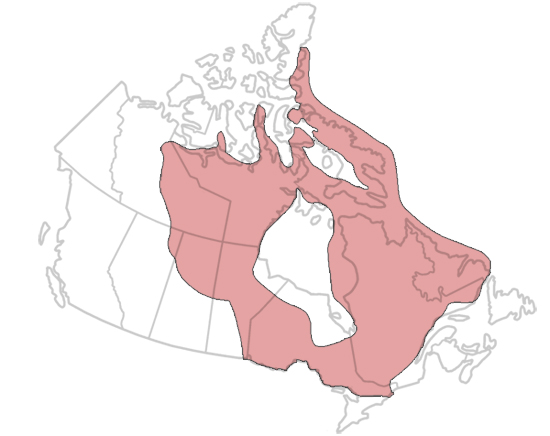
Canadian Shield
The Canadian Shield is Canada’s largest and oldest physiographic region. It covers about 48 per cent of Canada. That's 5 million km2, including freshwater lakes and Arctic islands. Phases of mountain building formed the rocks that make up the Canadian Shield. This process happened between 4 billion and 1 billion years ago. Weathering and erosion have given the Canadian Shield level or gently rolling skylines.
Western Cordillera
The Western Cordillera covers 1.6 million km2, or 16 per cent of Canada. It includes mountains, valleys, plateaus and plains. The region’s most continuous mountain chains are the Coast Mountains and the Rocky Mountains. The Coast Mountains are in the southwestern portion of the region. The Rocky Mountains are in the southeastern portion of the region. Between them is a belt of different types of terrain.
Canadian Arctic
Canada’s Arctic is north of the Arctic Circle. This region is 2.1 million km2, or 21 per cent of the country’s land area. The Canadian Arctic overlaps with other physiographic regions. These regions are the Canadian Shield, the Western Cordillera and the Interior Plains. They can be thought of as subregions of the Canadian Arctic. In addition, there are three other subregions: Innuitia, the Arctic Lowlands and the Arctic Coastal Plain. All of these subregions have continuous permafrost. Permafrost is land that is always frozen. The Canadian Arctic is also characterized by treeless tundra.
Appalachian Region
The Appalachian Region is about 3.6 per cent of Canada’s land surface. That’s about 360,000 km2. The Appalachian Region is a region of mountains. It is characterized by highlands and lowlands. Plate tectonic movements that happened between 480 million and 280 million years ago shaped the land in the region. Since then, weathering and erosion have removed several kilometres of rock.
Interior Plains
The Interior Plains region is 1.8 million km2. This is 18 per cent of Canada’s land surface. The Interior Plains have large areas of sedimentary bedrock. The southern Interior Plains are characterized by grassland vegetation. Further north is mixed-wood forest, then the coniferous boreal forest. At the northern end of the Interior Plains there is treeless tundra and polar deserts.
Hudson Bay Lowlands
The Hudson Bay Lowlands are 320,000 km2. This is about 3.2 per cent of Canada’s land surface. The Hudson Bay Lowlands are a sedimentary basin. Part of this basin (40 per cent) lies in the middle of the Canadian Shield. The remaining 60 per cent of the basin is underneath the waters of Hudson Bay and James Bay. The bedrock terrain is covered by sediment left behind by glaciers during the last Ice Age.
St. Lawrence Lowlands
The St. Lawrence Lowlands cover 1.8 per cent of Canada’s land surface, or 180,000 km2. It is the smallest of Canada’s physiographic regions. However, it is also the most densely populated (see also Human Geography and Canada; Human Settlement in Canada). The St. Lawrence Lowlands has three subregions: the west, central and east lowlands. The West St. Lawrence Lowland is between the Canadian Shield and Lakes Huron, Erie and Ontario. It includes the Niagara Escarpment and rolling fields. The Central St. Lawrence Lowland is in southeastern Ontario and southern Quebec. It has rolling topography and includes the seven Monteregian Hills (e.g. Mount Royal). The East St. Lawrence Lowland widens from the lower St. Lawrence River to the Gulf of St. Lawrence. It narrows again to the northeast of the Strait of Belle Isle. It includes plateaus and plains, and may be dry, forested or boggy.