Browse "Towns"
-
Article
Huntsville
Huntsville, Ont, incorporated as a town in 1900, population 19 056 (2011c), 18 280 (2006c). The Town of Huntsville is located 215 km north of Toronto on a short section of the Muskoka River connecting Vernon and Fairy lakes.
"https://d2ttikhf7xbzbs.cloudfront.net/media/media/d0fdd9f6-db3d-4408-99a3-2c5eb442fbea.jpg" // resources/views/front/categories/view.blade.php
https://d2ttikhf7xbzbs.cloudfront.net/media/media/d0fdd9f6-db3d-4408-99a3-2c5eb442fbea.jpg
-
Article
Iberville
Visitors are attracted by Iberville's impressive Roman Catholic church, local vineyards and picturesque riverside setting. Iberville and the surrounding region were hard hit by the January 1998 ice storm that slashed across eastern Ontario and southern Québec.
"https://d2ttikhf7xbzbs.cloudfront.net/media/media/6ecaaa8b-d704-4641-98f4-e22db45e4668.jpg" // resources/views/front/categories/view.blade.php
https://d2ttikhf7xbzbs.cloudfront.net/media/media/6ecaaa8b-d704-4641-98f4-e22db45e4668.jpg
-
Article
Indian Head
Indian Head, Sask, incorporated as a town in 1902, population 1815 (2011c), 1634 (2006c). The Town of Indian Head is located in the heart of Saskatchewan's richest farming area, south of the Qu'Appelle Valley, 69 km east of
"https://development.thecanadianencyclopedia.ca/images/tce_placeholder.jpg?v=e9dca980c9bdb3aa11e832e7ea94f5d9" // resources/views/front/categories/view.blade.php
https://development.thecanadianencyclopedia.ca/images/tce_placeholder.jpg?v=e9dca980c9bdb3aa11e832e7ea94f5d9
-
Article
Ingersoll
Ingersoll, Ont, incorporated as a town in 1865, population 12 146 (2011c), 11 760 (2006c). The Town of Ingersoll is situated on the THAMES RIVER, 36 km east of London.
"https://development.thecanadianencyclopedia.ca/images/tce_placeholder.jpg?v=e9dca980c9bdb3aa11e832e7ea94f5d9" // resources/views/front/categories/view.blade.php
https://development.thecanadianencyclopedia.ca/images/tce_placeholder.jpg?v=e9dca980c9bdb3aa11e832e7ea94f5d9
-
Article
Innisfail
Innisfail, Alta, incorporated as a town in 1903, population 7876 (2011c), 7331 (2006c). The Town of Innisfail is located on the CP Rail line 121 km north of Calgary.
"https://d2ttikhf7xbzbs.cloudfront.net/media/media/1e459b6f-fe80-4090-8780-016a87e863bd.jpg" // resources/views/front/categories/view.blade.php
https://d2ttikhf7xbzbs.cloudfront.net/media/media/1e459b6f-fe80-4090-8780-016a87e863bd.jpg
-
Article
Innisfil
Innisfil, Ontario, incorporated as a town in 1991, population 43,326 (2021 census), 36,566 (2016 census). The town of Innisfil is located 75 km north of Toronto along the shore of Lake Simcoe.
"https://d2ttikhf7xbzbs.cloudfront.net/media/media/4541da10-f493-4d2b-bf7b-9e1a825d7c64.jpg" // resources/views/front/categories/view.blade.php
https://d2ttikhf7xbzbs.cloudfront.net/media/media/4541da10-f493-4d2b-bf7b-9e1a825d7c64.jpg
-
Article
Inuvik
Inuvik, NWT, incorporated as a town in 1970, population 3463 (2011c), 3484 (2006c). The Town of Inuvik is located on the MACKENZIE RIVER delta, 97 km south of the BEAUFORT SEA and 1086 air km northwest of Yellowknife.
"https://d2ttikhf7xbzbs.cloudfront.net/media/media/e6b68eba-9d02-4243-97c0-eb058faa8ce2.jpg" // resources/views/front/categories/view.blade.php
https://d2ttikhf7xbzbs.cloudfront.net/media/media/e6b68eba-9d02-4243-97c0-eb058faa8ce2.jpg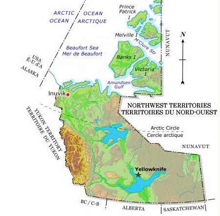
-
Article
Irishtown-Summerside
Irishtown-Summerside, NL, incorporated as a town in 1991, population 1428 (2011c), 1290 (2006c). Irishtown-Summerside is located on Humber Arm in the Bay of Islands near Corner Brook.
"https://development.thecanadianencyclopedia.ca/images/tce_placeholder.jpg?v=e9dca980c9bdb3aa11e832e7ea94f5d9" // resources/views/front/categories/view.blade.php
https://development.thecanadianencyclopedia.ca/images/tce_placeholder.jpg?v=e9dca980c9bdb3aa11e832e7ea94f5d9
-
Article
Iroquois Falls
Iroquois Falls, Ont, Town, incorporated as a town in 1915, population 4595 (2011c), 4729 (2006c). The Town of Iroquois Falls is located 334 km northwest of North Bay.
"https://development.thecanadianencyclopedia.ca/images/tce_placeholder.jpg?v=e9dca980c9bdb3aa11e832e7ea94f5d9" // resources/views/front/categories/view.blade.php
https://development.thecanadianencyclopedia.ca/images/tce_placeholder.jpg?v=e9dca980c9bdb3aa11e832e7ea94f5d9
-
Article
Jaffray Melick
Jaffray Melick, Ont, was a town from 1988 to 2000. Its former territory is now the easternmost section of the city of KENORA.
"https://d2ttikhf7xbzbs.cloudfront.net/media/media/1bf03a7f-ee0f-4f62-bd82-e4196d3f3040.jpg" // resources/views/front/categories/view.blade.php
https://d2ttikhf7xbzbs.cloudfront.net/media/media/1bf03a7f-ee0f-4f62-bd82-e4196d3f3040.jpg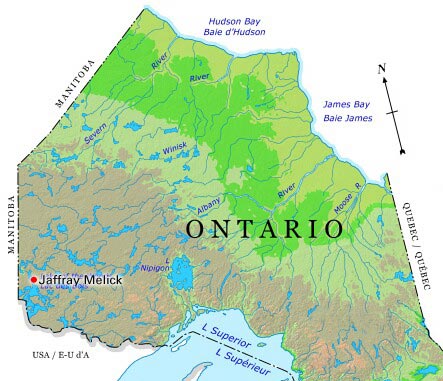
-
Article
Kamsack
Kamsack primarily serves as an agricultural service centre for the surrounding district, which contains both grain and mixed farms.
"https://development.thecanadianencyclopedia.ca/images/tce_placeholder.jpg?v=e9dca980c9bdb3aa11e832e7ea94f5d9" // resources/views/front/categories/view.blade.php
https://development.thecanadianencyclopedia.ca/images/tce_placeholder.jpg?v=e9dca980c9bdb3aa11e832e7ea94f5d9
-
Article
Kapuskasing
Kapuskasing, Ont, incorporated as a town in 1921, population 8196 (2011c), 8509 (2006c). The Town of Kapuskasing is located on the Kapuskasing River, 493 km northwest of North Bay.
"https://development.thecanadianencyclopedia.ca/images/tce_placeholder.jpg?v=e9dca980c9bdb3aa11e832e7ea94f5d9" // resources/views/front/categories/view.blade.php
https://development.thecanadianencyclopedia.ca/images/tce_placeholder.jpg?v=e9dca980c9bdb3aa11e832e7ea94f5d9
-
Article
Kensington
Owing to its crossroads location, the town received a station when the PEI Railway was constructed in 1873. Today Kensington is still a commercial centre, although it competes with the larger port town of Summerside.
"https://development.thecanadianencyclopedia.ca/images/tce_placeholder.jpg?v=e9dca980c9bdb3aa11e832e7ea94f5d9" // resources/views/front/categories/view.blade.php
https://development.thecanadianencyclopedia.ca/images/tce_placeholder.jpg?v=e9dca980c9bdb3aa11e832e7ea94f5d9
-
Article
Kentville
Kentville, NS, incorporated as a town in 1886, population 6094 (2011c), 5815 (2006c). The Town of Kentville is located on the Cornwallis River, 110 km northwest of Halifax.
"https://development.thecanadianencyclopedia.ca/images/tce_placeholder.jpg?v=e9dca980c9bdb3aa11e832e7ea94f5d9" // resources/views/front/categories/view.blade.php
https://development.thecanadianencyclopedia.ca/images/tce_placeholder.jpg?v=e9dca980c9bdb3aa11e832e7ea94f5d9
-
Article
Kindersley
Kindersley, Sask, incorporated as a town in 1911, population 4678 (2011c), 4412 (2006c). The Town of Kindersley is located in west-central Saskatchewan, 200 km southwest of Saskatoon and 65 km east of the Alberta border.
"https://development.thecanadianencyclopedia.ca/images/tce_placeholder.jpg?v=e9dca980c9bdb3aa11e832e7ea94f5d9" // resources/views/front/categories/view.blade.php
https://development.thecanadianencyclopedia.ca/images/tce_placeholder.jpg?v=e9dca980c9bdb3aa11e832e7ea94f5d9