Browse "Towns"
-
Article
Raymond
Raymond, Alberta, incorporated as a town in 1903, population 3,708 (2016 census), 3,743 (2011 census). The town of Raymond is located in southern Alberta, approximately 35 km south of Lethbridge. In the early 1900s the area was settled by Mormons and Japanese labourers (see also Japanese Canadians). The Raymond Stampede, Canada’s first rodeo, has been held in the town since 1902.
"https://d2ttikhf7xbzbs.cloudfront.net/media/media/073c1dc8-391d-4239-808d-814a185846c0.jpg" // resources/views/front/categories/view.blade.php
https://d2ttikhf7xbzbs.cloudfront.net/media/media/073c1dc8-391d-4239-808d-814a185846c0.jpg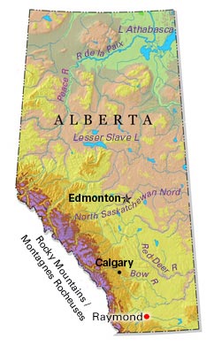
-
Article
Redcliff
Redcliff, Alta, incorporated as a town in 1912, population 5588 (2011c), 5116 (2006c). The Town of Redcliff is located adjacent to MEDICINE HAT and named for the outcroppings of red shale occurring along the banks of the nearby South Saskatchewan River.
"https://development.thecanadianencyclopedia.ca/images/tce_placeholder.jpg?v=e9dca980c9bdb3aa11e832e7ea94f5d9" // resources/views/front/categories/view.blade.php
https://development.thecanadianencyclopedia.ca/images/tce_placeholder.jpg?v=e9dca980c9bdb3aa11e832e7ea94f5d9
-
Article
Redwater
Redwater, Alberta, incorporated as a town in 1950, population 1915 (2011c), 2202 (2006c). The Town of Redwater is located 55 km northeast of Edmonton. The town takes its name from the Redwater River.
"https://d2ttikhf7xbzbs.cloudfront.net/media/media/4b45247f-6c8f-453c-a6fa-06eb8ef9ec7c.jpg" // resources/views/front/categories/view.blade.php
https://d2ttikhf7xbzbs.cloudfront.net/media/media/4b45247f-6c8f-453c-a6fa-06eb8ef9ec7c.jpg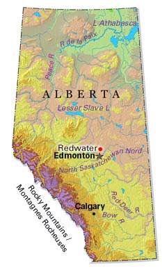
-
Article
Renfrew
Renfrew, Ontario, incorporated as a town in 1895, population 8,223 (2016 census), 8,218 (2011 census). The town of Renfrew is located on the Bonnechere River, 100 km west of Ottawa.
"https://development.thecanadianencyclopedia.ca/images/tce_placeholder.jpg?v=e9dca980c9bdb3aa11e832e7ea94f5d9" // resources/views/front/categories/view.blade.php
https://development.thecanadianencyclopedia.ca/images/tce_placeholder.jpg?v=e9dca980c9bdb3aa11e832e7ea94f5d9
-
Article
Naujaat
Naujaat, Nunavut, incorporated as a hamlet in 1978, population 1,225 (2021 census), 1,082 (2016 census). The hamlet of Naujaat is located on the north shore of Repulse Bay, which is on the south shore of the Rae Isthmus. For a period of time, Naujaat was known as Repulse Bay.
"https://development.thecanadianencyclopedia.ca/images/tce_placeholder.jpg?v=e9dca980c9bdb3aa11e832e7ea94f5d9" // resources/views/front/categories/view.blade.php
https://development.thecanadianencyclopedia.ca/images/tce_placeholder.jpg?v=e9dca980c9bdb3aa11e832e7ea94f5d9
-
Article
Richmond Hill
Richmond Hill, Ontario, is a city 23 km north of Lake Ontario, population 202,022 (2021 census), 195,022 (2016 census). It is one of nine municipalities that make up the Regional Municipality of York. The city is bordered by Aurora to the north, Whitchurch-Stouffville to the east, Markham to the east and south, Vaughan to the west and south, and King Township to the west. Richmond Hill became an incorporated village in 1872, changing status to town in 1957, and city in 2019. The modern borders were established in 1971 from the Town of Richmond Hill, as well as parts of King, Vaughan, Whitchurch and Markham Townships. Throughout history, the Richmond Hill area has been home to different Indigenous groups, namely the Huron Wendat, Haudenosaunee and Anishinaabeg. The land is covered by Treaty 13 and the Williams Treaties.
"https://d2ttikhf7xbzbs.cloudfront.net/media/new_article_images/RichmondHill/DowntownRichmondHill.jpg" // resources/views/front/categories/view.blade.php
https://d2ttikhf7xbzbs.cloudfront.net/media/new_article_images/RichmondHill/DowntownRichmondHill.jpg
-
Article
Riverview
Riverview, incorporated as a town in 1973, population 19 128 (2011c), 17 832 (2006c). The Town of Riverview is situated on the Petitcodiac River opposite MONCTON.
"https://development.thecanadianencyclopedia.ca/images/tce_placeholder.jpg?v=e9dca980c9bdb3aa11e832e7ea94f5d9" // resources/views/front/categories/view.blade.php
https://development.thecanadianencyclopedia.ca/images/tce_placeholder.jpg?v=e9dca980c9bdb3aa11e832e7ea94f5d9
-
Article
Roberval
A navigation centre for the lake and an internationally renowned summer resort until the early 20th century, Roberval also had a few sawmills. The Ursulines built their provincial convent here in 1882. A hospital was added in 1918.
"https://development.thecanadianencyclopedia.ca/images/tce_placeholder.jpg?v=e9dca980c9bdb3aa11e832e7ea94f5d9" // resources/views/front/categories/view.blade.php
https://development.thecanadianencyclopedia.ca/images/tce_placeholder.jpg?v=e9dca980c9bdb3aa11e832e7ea94f5d9
-
Article
Roblin
Roblin, Manitoba, incorporated as a village in 1913 and as a town in 1963, population 1774 (2011c), 1672 (2006c). The Town of Roblin is situated on Goose Lake 400 km northwest of Winnipeg near the Manitoba-Saskatchewan border.
"https://d2ttikhf7xbzbs.cloudfront.net/media/media/4bdc8f29-c5bc-4346-8b69-eacb517ce926.jpg" // resources/views/front/categories/view.blade.php
https://d2ttikhf7xbzbs.cloudfront.net/media/media/4bdc8f29-c5bc-4346-8b69-eacb517ce926.jpg
-
Article
Rocky Mountain House
Rocky Mountain House, Alberta, incorporated as a town in 1939, population 6,635 (2016 census), 6,933 (2011 census). The town of Rocky Mountain House is located on the North Saskatchewan River, 81 km west of Red Deer. It is near the site of the North West Company’s fur trade post of the same name.
"https://d2ttikhf7xbzbs.cloudfront.net/media/new_article_images/RockyMountainHouse/c007376.jpg" // resources/views/front/categories/view.blade.php
https://d2ttikhf7xbzbs.cloudfront.net/media/new_article_images/RockyMountainHouse/c007376.jpg
-
Article
Rosetown
Rosetown, Sask, incorporated as a town in 1911, population 2317 (2011c), 2277 (2006c). The Town of Rosetown is located 115 km southwest of SASKATOON. It is a focal point for the major transportation routes of the region and is
"https://development.thecanadianencyclopedia.ca/images/tce_placeholder.jpg?v=e9dca980c9bdb3aa11e832e7ea94f5d9" // resources/views/front/categories/view.blade.php
https://development.thecanadianencyclopedia.ca/images/tce_placeholder.jpg?v=e9dca980c9bdb3aa11e832e7ea94f5d9
-
Article
Rosthern
In 1891 and 1892 a group of Mennonite farmers, several from the Manitoba settlements, arrived in the area. Dr Seager WHEELER, a pioneer in scientific agriculture, had his farm in the area; it is now a national historic site.
"https://d2ttikhf7xbzbs.cloudfront.net/media/media/3aaaa54e-d3b3-45f2-97e7-ffa1b1d5118d.jpg" // resources/views/front/categories/view.blade.php
https://d2ttikhf7xbzbs.cloudfront.net/media/media/3aaaa54e-d3b3-45f2-97e7-ffa1b1d5118d.jpg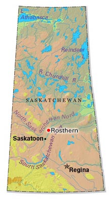
-
Article
Rothesay
Rothesay, NB, incorporated as a town in 1998, population 11 947 (2011c), 11 637 (2006c). It is situated on the eastern side of the Kennebecasis River, 22 km northeast of Saint John.
"https://development.thecanadianencyclopedia.ca/images/tce_placeholder.jpg?v=e9dca980c9bdb3aa11e832e7ea94f5d9" // resources/views/front/categories/view.blade.php
https://development.thecanadianencyclopedia.ca/images/tce_placeholder.jpg?v=e9dca980c9bdb3aa11e832e7ea94f5d9
-
Article
Russell (Man)
Russell, Manitoba, incorporated as a village in 1907 and as a town in 1913, population 1669 (2011c), 1590 (2006c). The Town of Russell is an agricultural service centre 350 km northwest of Winnipeg near the Manitoba-Saskatchewan border.
"https://development.thecanadianencyclopedia.ca/images/tce_placeholder.jpg?v=e9dca980c9bdb3aa11e832e7ea94f5d9" // resources/views/front/categories/view.blade.php
https://development.thecanadianencyclopedia.ca/images/tce_placeholder.jpg?v=e9dca980c9bdb3aa11e832e7ea94f5d9
-
Article
Sackville
Sackville, NB, incorporated as a town in 1903, population 5558 (2011c), 5411 (2006c). Sackville is situated 50 km southeast of Moncton on the Tantramar River, near the Nova Scotia border.
"https://d2ttikhf7xbzbs.cloudfront.net/media/media/5dbfbca9-4ef2-40d8-b045-723f078917dd.jpg" // resources/views/front/categories/view.blade.php
https://d2ttikhf7xbzbs.cloudfront.net/media/media/5dbfbca9-4ef2-40d8-b045-723f078917dd.jpg