Browse "Lakes & Reservoirs"
-
Article
Great Lakes
The Great Lakes are the largest group in a chain of large lakes (including Winnipeg, Athabasca, Great Slave and Great Bear) that lies along the southern boundary of the Canadian Shield. From west to east the Great Lakes comprise lakes Superior, Michigan (entirely in the US), Huron, St. Clair, Erie and Ontario. They have a total area of approximately 244,100 km 2 and drop from 183 m above sea level at Lake Superior to 74 m at Lake Ontario — the most dramatic drop occurring at Niagara Falls. Lake St Clair, while not properly a “great lake,” is considered part of this Laurentian chain.
"https://d2ttikhf7xbzbs.cloudfront.net/media/media/894ac3cf-cd0e-491f-a04f-53e7c18a4b00.jpg" // resources/views/front/categories/view.blade.php
https://d2ttikhf7xbzbs.cloudfront.net/media/media/894ac3cf-cd0e-491f-a04f-53e7c18a4b00.jpg
-
Article
Great Slave Lake
Great Slave Lake is located in the Northwest Territories. It is the second largest lake entirely within Canadian borders, the fifth largest in North America, and the tenth largest in the world.
"https://d2ttikhf7xbzbs.cloudfront.net/media/media/13ae1e1d-36ba-43cf-8b14-a08a9d6d7cfa.jpg" // resources/views/front/categories/view.blade.php
https://d2ttikhf7xbzbs.cloudfront.net/media/media/13ae1e1d-36ba-43cf-8b14-a08a9d6d7cfa.jpg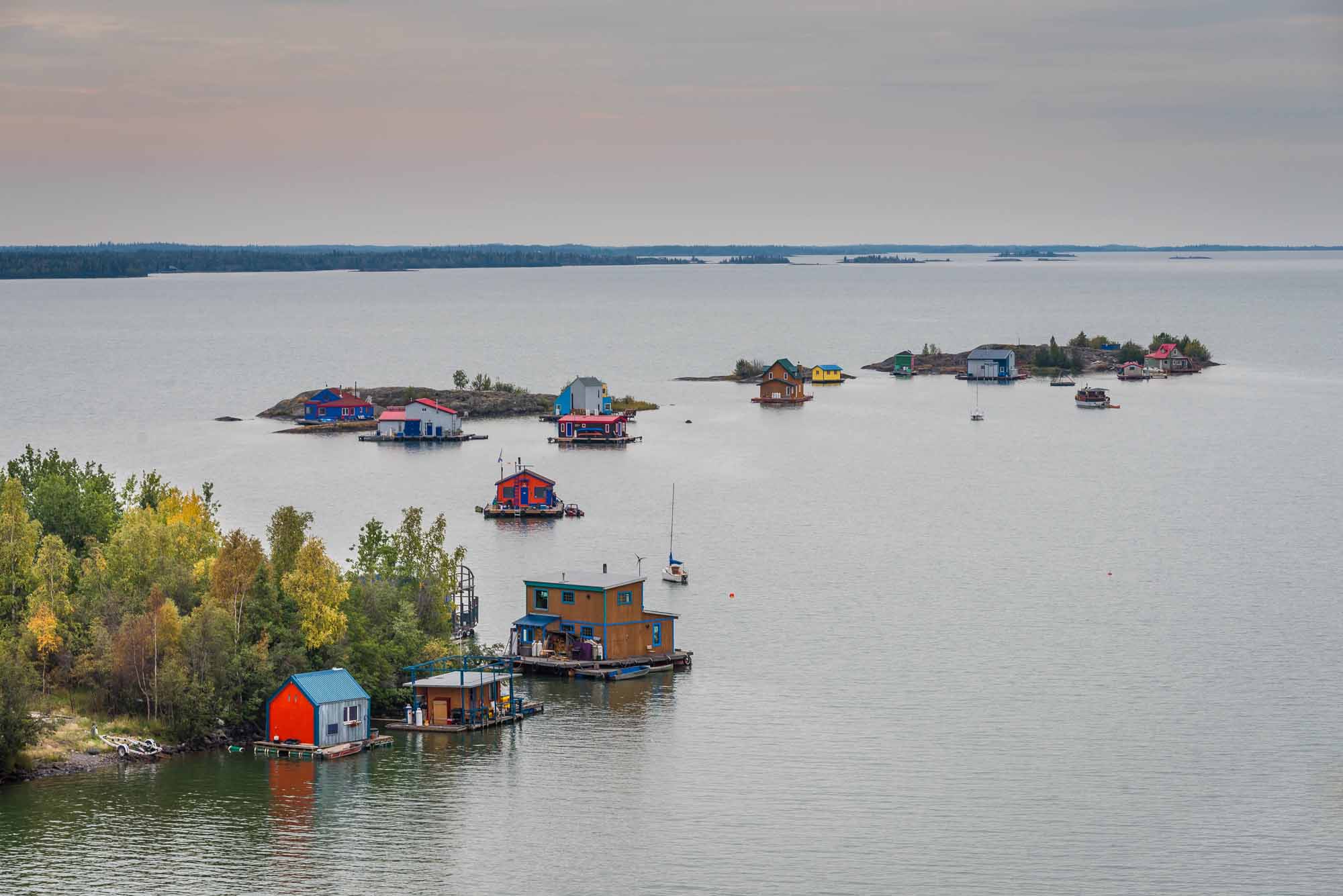
-
List
Indigenous Names of Rivers and Lakes in Canada
The names of many rivers and lakes in Canada have Indigenous origins. These bodies of water are named for Indigenous people, places, and aspects of Indigenous culture. Some of these lakes and rivers still bear the original name given to them by Indigenous people. Others have been renamed using an Indigenous word as a means of recognizing Indigenous history and working toward reconciliation. This list article explores the Indigenous names of five rivers and five lakes in Canada. (See also Longest Rivers in Canada and Largest Lakes in Canada.)
"https://d2ttikhf7xbzbs.cloudfront.net/media/media/19ec5b64-165b-4f1c-b539-c89700680c09.jpg" // resources/views/front/categories/view.blade.php
https://d2ttikhf7xbzbs.cloudfront.net/media/media/19ec5b64-165b-4f1c-b539-c89700680c09.jpg
-
Article
Kawartha Lakes
The Kawartha Lakes are a chain of interconnected lakes in south-central Ontario, forming the Trent River's upper watershed. These lakes range in size from 2 to 83 km2. Most of the lakes are located in the city of Kawartha Lakes and Peterborough County.
"https://d2ttikhf7xbzbs.cloudfront.net/kawarthalakes/Bobcaygeon.jpg" // resources/views/front/categories/view.blade.php
https://d2ttikhf7xbzbs.cloudfront.net/kawarthalakes/Bobcaygeon.jpg
-
Article
Kootenay Lake
Kootenay Lake, 407 km2, elev 532 m, is situated in the mountainous southeastern interior of BC.
"https://d2ttikhf7xbzbs.cloudfront.net/media/media/889433fb-787d-4d50-9c0d-a3cfcfcff6a5.jpg" // resources/views/front/categories/view.blade.php
https://d2ttikhf7xbzbs.cloudfront.net/media/media/889433fb-787d-4d50-9c0d-a3cfcfcff6a5.jpg
-
Article
Lac à l' Eau Claire
Lac à l'Eau Claire, 1383 km2, elevation 241 m, max length 71 km, is located in northwestern Québec about 133 km east of the southeastern shore of Hudson Bay. Probably formed by the impact of a METEORITE, the lake drains west via Rivière à l'Eau Claire into Lac GUILLAUME-DELISLE.
"https://development.thecanadianencyclopedia.ca/images/tce_placeholder.jpg?v=e9dca980c9bdb3aa11e832e7ea94f5d9" // resources/views/front/categories/view.blade.php
https://development.thecanadianencyclopedia.ca/images/tce_placeholder.jpg?v=e9dca980c9bdb3aa11e832e7ea94f5d9
-
Article
Lac Bienville
Lac Bienville, 1249 km2, elevation 426 m, maximum length 89 km, is located in a sparsely populated region of northern Québec. This elongated lake, dotted with numerous islands, is fed by Lacs Louet and Ossant. It drains west, via the Grande Rivière de la Baleine (Great Whale River), into Hudson Bay.
"https://development.thecanadianencyclopedia.ca/images/tce_placeholder.jpg?v=e9dca980c9bdb3aa11e832e7ea94f5d9" // resources/views/front/categories/view.blade.php
https://development.thecanadianencyclopedia.ca/images/tce_placeholder.jpg?v=e9dca980c9bdb3aa11e832e7ea94f5d9
-
Article
Lac Guillaume-Delisle
Lac Guillaume-Delisle, 712 km2, is a large, triangular, saltwater lake in northern Québec, connected to the eastern shore of Hudson Bay by Le Goulet, a 5 km long narrow channel.
"https://development.thecanadianencyclopedia.ca/images/tce_placeholder.jpg?v=e9dca980c9bdb3aa11e832e7ea94f5d9" // resources/views/front/categories/view.blade.php
https://development.thecanadianencyclopedia.ca/images/tce_placeholder.jpg?v=e9dca980c9bdb3aa11e832e7ea94f5d9
-
Article
Lac la Martre
Lac la Martre, 1777 km2, elev 265 m, max length 76 km, is located in the Northwest Territories, 50 km west of Behchokò and 150 km northwest of Yellowknife, and 346 km south of the Arctic Circle. The settlement of WHATÌ is located at the southeastern corner of the lake.
"https://development.thecanadianencyclopedia.ca/images/tce_placeholder.jpg?v=e9dca980c9bdb3aa11e832e7ea94f5d9" // resources/views/front/categories/view.blade.php
https://development.thecanadianencyclopedia.ca/images/tce_placeholder.jpg?v=e9dca980c9bdb3aa11e832e7ea94f5d9
-
Article
Lac La Ronge
Lac La Ronge, 1414 km2, elevation 364 m, is located in the rugged, sparsely populated Canadian Shield country of central Saskatchewan, 235 km north of Prince Albert. About 58 km long and studded with many islands, it drains northeast via the Rapid River into the Churchill River.
"https://development.thecanadianencyclopedia.ca/images/tce_placeholder.jpg?v=e9dca980c9bdb3aa11e832e7ea94f5d9" // resources/views/front/categories/view.blade.php
https://development.thecanadianencyclopedia.ca/images/tce_placeholder.jpg?v=e9dca980c9bdb3aa11e832e7ea94f5d9
-
Article
Lac Mégantic (lake)
Lac Mégantic, 26 km2, elev 395 m, 75 m deep, is located in a depression of the Appalachians in southern Québec, 6 km from the US border. LAC-MÉGANTIC, the only town of the region, is located at its outlet, which is the source of the Rivière CHAUDIÈRE.
"https://development.thecanadianencyclopedia.ca/images/tce_placeholder.jpg?v=e9dca980c9bdb3aa11e832e7ea94f5d9" // resources/views/front/categories/view.blade.php
https://development.thecanadianencyclopedia.ca/images/tce_placeholder.jpg?v=e9dca980c9bdb3aa11e832e7ea94f5d9
-
Article
Lac Mistassini
Lac Mistassini, 2335 km2, elevation 372 m, max length 161 km and width 19 km, is located in central Québec, 360 km east of JAMES BAY and 220 km northwest of Lac SAINT-JEAN.
"https://development.thecanadianencyclopedia.ca/images/tce_placeholder.jpg?v=e9dca980c9bdb3aa11e832e7ea94f5d9" // resources/views/front/categories/view.blade.php
https://development.thecanadianencyclopedia.ca/images/tce_placeholder.jpg?v=e9dca980c9bdb3aa11e832e7ea94f5d9
-
Article
Lac Saint-Jean
The Kakouchaks, the local population of Innu, began trading with the Europeans at TADOUSSAC in the 16th century. Later, Lac Saint-Jean was made part of the King's Domain (1674), land reserved for trapping and farmed out to interested parties; a first trading post was built at Métabetchouane in 1676.
"https://d2ttikhf7xbzbs.cloudfront.net/media/media/70035c01-a62b-498f-ac5e-c845f620a798.jpg" // resources/views/front/categories/view.blade.php
https://d2ttikhf7xbzbs.cloudfront.net/media/media/70035c01-a62b-498f-ac5e-c845f620a798.jpg
-
Article
Lac Seul
Lac Seul, 1658 km2, elev 357 m, 55 m deep, located in northwestern Ontario, 50 km N of Dryden, drains W via the English and Winnipeg rivers to Lk Winnipeg.
"https://development.thecanadianencyclopedia.ca/images/tce_placeholder.jpg?v=e9dca980c9bdb3aa11e832e7ea94f5d9" // resources/views/front/categories/view.blade.php
https://development.thecanadianencyclopedia.ca/images/tce_placeholder.jpg?v=e9dca980c9bdb3aa11e832e7ea94f5d9
-
Article
Lac Shawinigan
Shawinigan, Lac, 3.2 km2, 6.3 km long, 80 m deep, lies on Québec's Laurentian Plateau, 70 km north of Lac Saint-Pierre on the St Lawrence River. This lake of glacial gouging is prolonged to the east by Petit Lac Shawinigan, Lac Bernard and Lac en Croix.
"https://development.thecanadianencyclopedia.ca/images/tce_placeholder.jpg?v=e9dca980c9bdb3aa11e832e7ea94f5d9" // resources/views/front/categories/view.blade.php
https://development.thecanadianencyclopedia.ca/images/tce_placeholder.jpg?v=e9dca980c9bdb3aa11e832e7ea94f5d9