Browse "Geographical features"
-
Article
Lake Ontario
Lake Ontario is 18,960 km2 (10,000 km2 in Canada), with a drainage area of 60,030 km2, an elevation of 75 m, a mean depth of 86 m (max 244 m), length 311 km and width 85 km. It is the smallest in surface area and most easterly of the Great Lakes and eighth-largest body of fresh water in North America. The lake receives most of its water supply from the other Great Lakes through the Niagara River and discharges into the St Lawrence River through the Kingston Basin at its northeast end. Other tributaries are the Genesee, Oswego and Black rivers in New York state and the Trent River in Ontario. (See also Largest Lakes in Canada.)
"https://d2ttikhf7xbzbs.cloudfront.net/media/media/aa619f1e-89b3-414d-9f9c-3a5c9c0b0097.jpg" // resources/views/front/categories/view.blade.php
https://d2ttikhf7xbzbs.cloudfront.net/media/media/aa619f1e-89b3-414d-9f9c-3a5c9c0b0097.jpg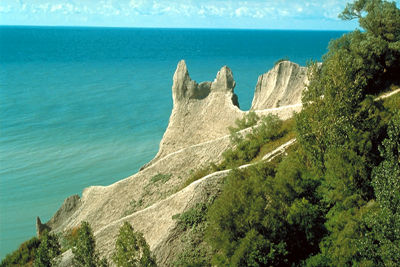
-
Article
Lake Simcoe
Lake Simcoe, 744 km2, elevation 219 m, is situated in southern Ontario between Georgian Bay and Lake Ontario, 65 km north of Toronto. In the north, The Narrows divides it from Lake Couchiching at Orillia, and both lakes drain northwesterly via the Severn River to Georgian Bay.
"https://development.thecanadianencyclopedia.ca/images/tce_placeholder.jpg?v=e9dca980c9bdb3aa11e832e7ea94f5d9" // resources/views/front/categories/view.blade.php
https://development.thecanadianencyclopedia.ca/images/tce_placeholder.jpg?v=e9dca980c9bdb3aa11e832e7ea94f5d9
-
Article
Lake St. Clair
Lake St. Clair, 1,114 km, elevation 175 m, average depth 3.7 m, is bordered by the province of Ontario to the east and the state of Michigan to the west. Almost circular in shape, it has a length of 42 km and a maximum width of 39 km. It is connected to Lake Huron to the north by the St. Clair River and drains into Lake Erie to the south via the Detroit River. Lake St. Clair is part of the St. Lawrence Seaway, a significant transportation route stretching from Lake Superior through the Great Lakes to the Gulf of St. Lawrence. The cities of Windsor, Ontario, and Detroit, Michigan, are located at the southwest end of the lake, making it a popular site for recreational fishing and boating.
"https://d2ttikhf7xbzbs.cloudfront.net/media/media/a2d33512-9337-43be-82e2-70685b5a7326.jpg" // resources/views/front/categories/view.blade.php
https://d2ttikhf7xbzbs.cloudfront.net/media/media/a2d33512-9337-43be-82e2-70685b5a7326.jpg
-
Article
Lake Superior
Lake Superior is one of the largest bodies of fresh water in the world, containing more water than all the other Great Lakes combined. With an area of 82,100 km2 (of which 28,750 km2 lies in Canada), when including the American portion, Lake Superior is Canada’s largest lake. It has a shoreline of 2,938 km, with the north shore bordering on Ontario and the south shore on the states of Michigan, Wisconsin and Minnesota. The lake is 563 km long, 257 km wide, with a mean depth of 147 m and a maximum depth of 406 m. It has an elevation of 183 m.
"https://d2ttikhf7xbzbs.cloudfront.net/media/media/670a98ba-b8c3-47aa-92f9-ac92cf084645.jpg" // resources/views/front/categories/view.blade.php
https://d2ttikhf7xbzbs.cloudfront.net/media/media/670a98ba-b8c3-47aa-92f9-ac92cf084645.jpg
-
Article
Lake Timiskaming
Lake Timiskaming (Lac Témiscamingue), 304 km2, 108 km long, elev 180 m, is located on the Ontario and Québec border in the southwestern corner of Québec. Varying from a few hundred metres to 8 km in width, Lake Timiskaming straddles the boundary, half in Ontario and half in Québec.
"https://development.thecanadianencyclopedia.ca/images/tce_placeholder.jpg?v=e9dca980c9bdb3aa11e832e7ea94f5d9" // resources/views/front/categories/view.blade.php
https://development.thecanadianencyclopedia.ca/images/tce_placeholder.jpg?v=e9dca980c9bdb3aa11e832e7ea94f5d9
-
Article
Lake Winnipeg
Lake Winnipeg, 23,750 km2, elevation 217 m, estimated maximum depth 36 m, sixth-largest freshwater lake in Canada, is located in central Manitoba. Extending 416 km north-south, it drains approximately 984,200 km2 of land by way of the Saskatchewan, Red-Assiniboine and Winnipeg river systems. (See also Largest Lakes in Canada.)
"https://d2ttikhf7xbzbs.cloudfront.net/media/media/1c6f92bc-560d-45fe-a4b3-ee7504d34131.jpg" // resources/views/front/categories/view.blade.php
https://d2ttikhf7xbzbs.cloudfront.net/media/media/1c6f92bc-560d-45fe-a4b3-ee7504d34131.jpg
-
Article
Lake Winnipegosis
Winnipegosis, Lake, 5370 km2, 195 km long, elev 254 m, maximum depth 12 m, Canada's eleventh-largest lake, is located in west-central Manitoba.
"https://development.thecanadianencyclopedia.ca/images/tce_placeholder.jpg?v=e9dca980c9bdb3aa11e832e7ea94f5d9" // resources/views/front/categories/view.blade.php
https://development.thecanadianencyclopedia.ca/images/tce_placeholder.jpg?v=e9dca980c9bdb3aa11e832e7ea94f5d9
-
Article
Lancaster Sound
Lancaster Sound, an arm of Baffin Bay and a major passage through the Arctic Archipelago, is 400 km long and some 100 km wide.
"https://development.thecanadianencyclopedia.ca/images/tce_placeholder.jpg?v=e9dca980c9bdb3aa11e832e7ea94f5d9" // resources/views/front/categories/view.blade.php
https://development.thecanadianencyclopedia.ca/images/tce_placeholder.jpg?v=e9dca980c9bdb3aa11e832e7ea94f5d9
-
Article
Land
Earth's surface experiences change driven by relief, sea level, hydroclimate and human activity. Extreme hydroclimatic events combined with human activity on steep slopes and/or adjacent to low-lying coasts generate natural hazards.
"https://d2ttikhf7xbzbs.cloudfront.net/media/media/da6ae2ec-e05e-46fd-916c-6185a6a86215.jpg" // resources/views/front/categories/view.blade.php
https://d2ttikhf7xbzbs.cloudfront.net/media/media/da6ae2ec-e05e-46fd-916c-6185a6a86215.jpg
-
"https://development.thecanadianencyclopedia.ca/images/tce_placeholder.jpg?v=e9dca980c9bdb3aa11e832e7ea94f5d9" // resources/views/front/categories/view.blade.php
https://development.thecanadianencyclopedia.ca/images/tce_placeholder.jpg?v=e9dca980c9bdb3aa11e832e7ea94f5d9
-
Article
Landsat Island
A small island 20 km off the northeast Labrador coast, named in recognition of the fact that it was first detected on imagery from the satellite Landsat-1. This satellite, designed for Earth-monitoring, was the first of a continuing series launched by the US having transmissions received in Canada.
"https://development.thecanadianencyclopedia.ca/images/tce_placeholder.jpg?v=e9dca980c9bdb3aa11e832e7ea94f5d9" // resources/views/front/categories/view.blade.php
https://development.thecanadianencyclopedia.ca/images/tce_placeholder.jpg?v=e9dca980c9bdb3aa11e832e7ea94f5d9
-
List
Largest Lakes in Canada
Surveys suggest that there may be as many as 2 million lakes in Canada. While some look like small scratches on the country’s surface, many are quite large. Nearly fourteen per cent of the world’s lakes with surface areas over 500 km2 are located in Canada. Below is a list of the largest of these large lakes. The list is ordered by the lake’s total surface area, not just the portions within Canadian borders.
"https://d2ttikhf7xbzbs.cloudfront.net/media/media/6250e461-dc90-4c92-a300-ab48c59d20a8.jpg" // resources/views/front/categories/view.blade.php
https://d2ttikhf7xbzbs.cloudfront.net/media/media/6250e461-dc90-4c92-a300-ab48c59d20a8.jpg
-
Article
Laurentian Highlands
Although the other limits are less well defined, the highlands may be considered to extend 100-200 km northward from the scarps and to stretch from the Gatineau River in the west (mean elevation 400 m) some 550 km to the SAGUENAY RIVER in the northeast.
"https://d2ttikhf7xbzbs.cloudfront.net/media/media/081947b9-bef7-47f0-b7c2-f8dbb47f7f9a.jpg" // resources/views/front/categories/view.blade.php
https://d2ttikhf7xbzbs.cloudfront.net/media/media/081947b9-bef7-47f0-b7c2-f8dbb47f7f9a.jpg
-
Article
Lesser Slave Lake
The earliest non-Indigenous settlement in the area evolved at the west end of the lake, off Buffalo Bay, where the North West Company established a post (1802) and the Roman Catholic Church followed with a mission (1872).
"https://d2ttikhf7xbzbs.cloudfront.net/media/media/4ec4a212-b4ef-4fde-844a-ba30ef433515.jpg" // resources/views/front/categories/view.blade.php
https://d2ttikhf7xbzbs.cloudfront.net/media/media/4ec4a212-b4ef-4fde-844a-ba30ef433515.jpg
-
Article
Liard River
The Liard River is 1,115 km long and is a major tributary to the Mackenzie River.
"https://d2ttikhf7xbzbs.cloudfront.net/media/media/d8c9eefb-7ec2-49a9-afc5-1b3766fa968f.jpg" // resources/views/front/categories/view.blade.php
https://d2ttikhf7xbzbs.cloudfront.net/media/media/d8c9eefb-7ec2-49a9-afc5-1b3766fa968f.jpg