Browse "Transportation"
-
List
Iconic Streets in Canada
Every city has a few streets that stand out above the rest. Perhaps they’re a shopping haven, like Vancouver’s Robson Street, or lined with landmarks, like Ottawa’s Sussex Drive. Other roads earned their fame as the site of a rebellion or a gold rush. Below is a list of ten of Canada’s most iconic streets, but there are many more. What street tells the story of your city?
"https://d2ttikhf7xbzbs.cloudfront.net/media/new_article_images/IconicStreets/SaintLaurentBlvd.jpg" // resources/views/front/categories/view.blade.php
https://d2ttikhf7xbzbs.cloudfront.net/media/new_article_images/IconicStreets/SaintLaurentBlvd.jpg
-
Article
I'm Alone
I'm Alone, a rumrunner based in Lunenburg, NS, one of several hundred vessels that supplied illicit liquor to a PROHIBITION-bound US during the 1920s. In March 1929 a US Coast Guard cutter sighted it when it had engine trouble in the Gulf of Mexico.
"https://development.thecanadianencyclopedia.ca/images/tce_placeholder.jpg?v=e9dca980c9bdb3aa11e832e7ea94f5d9" // resources/views/front/categories/view.blade.php
https://development.thecanadianencyclopedia.ca/images/tce_placeholder.jpg?v=e9dca980c9bdb3aa11e832e7ea94f5d9
-
Article
Intercolonial Railway
The Intercolonial Railway was a rail line that operated from 1872 to 1918, connecting Nova Scotia, New Brunswick, Québec and Ontario. The line was Canada’s first national infrastructure project. Plans for its construction date to the 1830s, but the project only gained momentum during the Confederation conferences of 1864 in Charlottetown and Québec City, where construction of the Intercolonial Railway was negotiated for the Maritime colonies’ entry to British North American union. Construction began shortly after Canada became a country in 1867, with most lines completed by the mid-1870s.
"https://d2ttikhf7xbzbs.cloudfront.net/Intercolonial_Locomotive_76.jpg" // resources/views/front/categories/view.blade.php
https://d2ttikhf7xbzbs.cloudfront.net/Intercolonial_Locomotive_76.jpg
-
Article
Lachine Canal
The Lachine Canal passes through the southwestern part of the island of Montréal, from the Old Port to the borough of Lachine, where it flows into Lake Saint-Louis.
"https://d2ttikhf7xbzbs.cloudfront.net/media/media/3cff11c1-33f8-46e7-a459-1dcfb3bd09e1.jpg" // resources/views/front/categories/view.blade.php
https://d2ttikhf7xbzbs.cloudfront.net/media/media/3cff11c1-33f8-46e7-a459-1dcfb3bd09e1.jpg
-
Article
Liard Highway
Liard Highway is an all-weather road linking northern British Columbia and the Northwest Territories. Beginning 27 km north of Fort Nelson on the Alaska Highway, it runs 400 km north to join the Mackenzie Highway a short distance south of Fort Simpson, NWT.
"https://development.thecanadianencyclopedia.ca/images/tce_placeholder.jpg?v=e9dca980c9bdb3aa11e832e7ea94f5d9" // resources/views/front/categories/view.blade.php
https://development.thecanadianencyclopedia.ca/images/tce_placeholder.jpg?v=e9dca980c9bdb3aa11e832e7ea94f5d9
-
Article
Lions Gate Bridge
Lions Gate Bridge, which officially opened on 29 May 1939, spans Burrard Inlet at the First Narrows, connecting Stanley Park and Vancouver’s city centre to the North Shore.
"https://d2ttikhf7xbzbs.cloudfront.net/media/media/f3a1aab8-0bf8-48ec-bd53-f9595750a66d.jpg" // resources/views/front/categories/view.blade.php
https://d2ttikhf7xbzbs.cloudfront.net/media/media/f3a1aab8-0bf8-48ec-bd53-f9595750a66d.jpg
-
Article
Locomotives and Rolling Stock
The first locomotive to be constructed in Canada was built by the James Good family (1853) of Toronto. Named Toronto, the locomotive had a set of 4 driving wheels and 4 small front wheels for better travel through curves.
"https://d2ttikhf7xbzbs.cloudfront.net/media/media/d2b77d1e-1c32-438b-94cb-2761961ea891.jpg" // resources/views/front/categories/view.blade.php
https://d2ttikhf7xbzbs.cloudfront.net/media/media/d2b77d1e-1c32-438b-94cb-2761961ea891.jpg
-
Article
Mackenzie-Grease Trail
The Mackenzie-Grease Trail represents the final 350 km link which Alexander Mackenzie followed in the first recorded crossing of continental North America in 1793.
"https://development.thecanadianencyclopedia.ca/images/tce_placeholder.jpg?v=e9dca980c9bdb3aa11e832e7ea94f5d9" // resources/views/front/categories/view.blade.php
https://development.thecanadianencyclopedia.ca/images/tce_placeholder.jpg?v=e9dca980c9bdb3aa11e832e7ea94f5d9
-
Article
Mackenzie Highway
Eighty km northwest of Enterprise, a ferry connects with the highway to Yellowknife, and connecting roads to the east serve Fort Resolution and Fort Smith. The section from Enterprise to Hay River is now a separate highway. First built as an all-weather road, some of its length has been paved.
"https://d2ttikhf7xbzbs.cloudfront.net/media/media/2862aeaf-cace-4b85-aac6-6d4f4ad9c96e.jpg" // resources/views/front/categories/view.blade.php
https://d2ttikhf7xbzbs.cloudfront.net/media/media/2862aeaf-cace-4b85-aac6-6d4f4ad9c96e.jpg
-
Article
Mackinaw Boat
Mackinaw Boat, a strong flat-bottomed boat, pointed at each end and with a hold in the middle, was used by fur traders during the French regime for running downstream. It was later adapted for open water by the addition of 2 sails and a steering oar. By the 1870s a distinctive type, 6.7 m to 8.
"https://development.thecanadianencyclopedia.ca/images/tce_placeholder.jpg?v=e9dca980c9bdb3aa11e832e7ea94f5d9" // resources/views/front/categories/view.blade.php
https://development.thecanadianencyclopedia.ca/images/tce_placeholder.jpg?v=e9dca980c9bdb3aa11e832e7ea94f5d9
-
Article
Montreal Metro
The Montreal metro opened on 14 October 1966. The second Canadian subway system after Toronto’s, which opened in 1954, the Montreal metro was the first subway in North America to run on rubber tires instead of metal wheels. Extensions to the Montreal metro were built on Montreal Island over the two decades after it opened, and then to the city of Laval, on the island of Île Jésus, during the 2000s. The system runs entirely underground, and each station has a distinct architecture and design. The Montreal metro consists of four lines running a total of 71 km and serving 68 stations. In 2018, its passengers made more than 383 million trips.
"https://d2ttikhf7xbzbs.cloudfront.net/media/media/7cb43abc-85f5-4380-adb4-56f13bfebb41.jpg" // resources/views/front/categories/view.blade.php
https://d2ttikhf7xbzbs.cloudfront.net/media/media/7cb43abc-85f5-4380-adb4-56f13bfebb41.jpg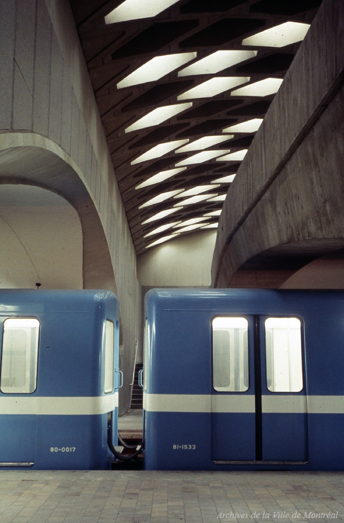
-
Article
National Transcontinental Railway
The NTR's development was rooted in the power play between railway entrepreneurs and politicians of the early twentieth century.
"https://d2ttikhf7xbzbs.cloudfront.net/media/media/2975528e-0b6f-4de7-8563-c6cdb226aa1a.jpg" // resources/views/front/categories/view.blade.php
https://d2ttikhf7xbzbs.cloudfront.net/media/media/2975528e-0b6f-4de7-8563-c6cdb226aa1a.jpg
-
Article
Native People's Caravan
The Native People’s Caravan was a cross-country mobile protest that took place in 1974. Its main purpose was to raise awareness about the poor living conditions and discrimination experienced by Indigenous peoples in Canada. It travelled from Vancouver to Ottawa, where the subsequent occupation of a vacant warehouse on Victoria Island, near Parliament Hill, extended into 1975. The caravan brought various Indigenous groups together in protest of broken treaties, as well as a lack of government-supported education, housing and health care. As a result, meetings between Cabinet ministers and Indigenous leaders became more frequent. The protest is remembered as an important turning point in Indigenous activism in Canada.
"https://d2ttikhf7xbzbs.cloudfront.net/media/media/e9e4a925-a033-404d-9819-a3bb46fe9c8e.jpg" // resources/views/front/categories/view.blade.php
https://d2ttikhf7xbzbs.cloudfront.net/media/media/e9e4a925-a033-404d-9819-a3bb46fe9c8e.jpg
-
Article
Northwest Staging Route
The Northwest Staging Route, an air route from Edmonton, over northwestern Canada to Fairbanks, Alaska, was planned before WWII by Canada, developed and built by Canada and the US between 1940-44.
"https://development.thecanadianencyclopedia.ca/images/tce_placeholder.jpg?v=e9dca980c9bdb3aa11e832e7ea94f5d9" // resources/views/front/categories/view.blade.php
https://development.thecanadianencyclopedia.ca/images/tce_placeholder.jpg?v=e9dca980c9bdb3aa11e832e7ea94f5d9
-
Article
Port of Quebec
Throughout its history, the Port of Quebec has undergone numerous changes reflecting the needs and concerns of the day. From its initial military role under the French regime, the Port of Quebec turned to commerce and transformed radically in the 19th century as a result of the timber trade and immigration. These two new realities had major repercussions on the port’s development, which adapted to accommodate ships of increasingly higher tonnage. With its sizable ocean port, the third largest in North America after New York and New Orleans, Quebec became the primary gateway to Canada for hundreds of thousands of immigrants arriving by sea.
"https://d2ttikhf7xbzbs.cloudfront.net/media/new_article_images/portdequebec/1024px-Quebec-Maasdam.JPG" // resources/views/front/categories/view.blade.php
https://d2ttikhf7xbzbs.cloudfront.net/media/new_article_images/portdequebec/1024px-Quebec-Maasdam.JPG